There's so much to respond to. Thanks for the amazing response!
Orion wrote:We have some of those metal ones in our parks as well, like Yosemite.
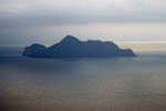
Assuming you want to maintain an accurate vertical/horizontal aspect I think part of the success would be choosing an appropriate scale. For example, there's a very dramatic peak just off shore of Lk. St. Clair (I can't remember the name of it) which just has to look cool as a sculpture -- but only if the scale of the piece is appropriate for it. Unfortunately, mapping data probably doesn't exist at the scale required for that.
How much do you imagine one of these would cost? Would they each be a custom job?
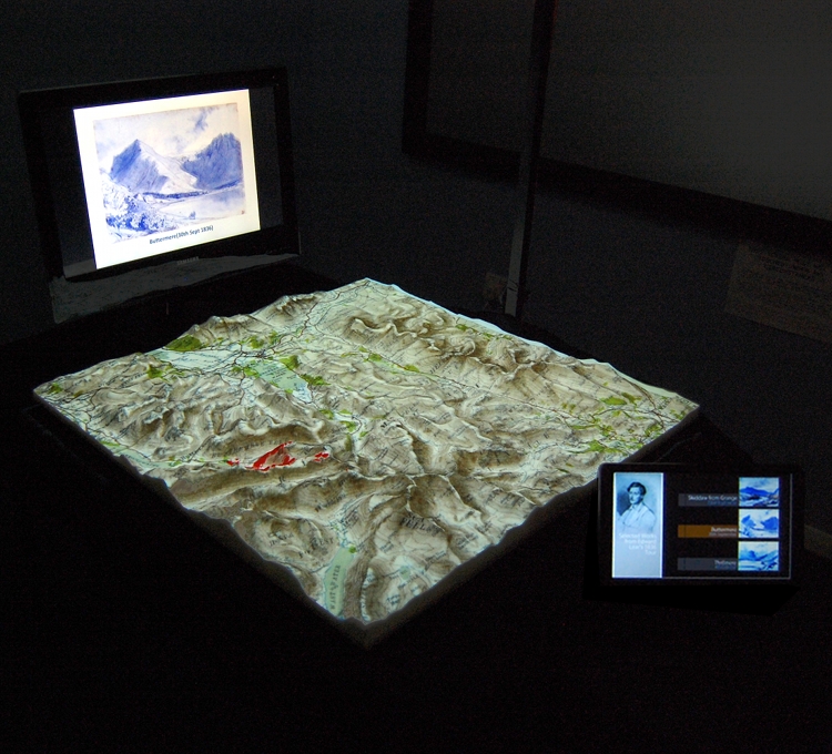
Yes, scale is hugely important. I've done some more experimenting, with Mt. Taranaki in New Zealand and Wilson's Promontory in Victoria, and I've found that it's possible to make flatter terrain look good, if the whole object is wider and flatter. I'll post photos soon.
Also, the mountain that you're thinking of, if I'm not wrong, is Mt. Olympus. It's the one that you can see from near Narcissus hut, and it really is a spectacular feature on my Lake St. Clair print. Unfortunately, the data I have for it isn't high enough resolution to do just it.
At the moment, each new map requires some time to produce. However, there are ways to improve my efficiency if I get a lot of requests.
As for cost, I already have a few up on my drop-shipping site;
https://www.shapeways.com/shops/Mortar_Art?section=Maps for reference on pricing. The overheads accounts for more than 2/3's of the cost, but again, if demand goes up, it won't be impossible to improve efficiency. So far, all of the models on Shapeways are there as tests, and have not been optimised for cost or efficiency of manufacturing.
I can also print at home in PLA plastic for the costs you see there, although no larger than 315x250mm. Prices at home will differ from Shapeways. For example, the WIlson's Promontory piece is $90 usd there, but I can already afford to make that for $60aud, despite it's large size.
north-north-west wrote:Mount Roland and the Fosseys. Murchison. Eldon Range. DuCanes. Western Arthurs. Southern Range, from Lune River to PB. The Frenchmans area - flattish near the road but once you start climbing it gets pretty dramatic, and if you include everything from Agamemnon to Clytemnestra and the Irenabyss it'd be stunning.
The Main Range. Karijini. The West MacDonnells.
That's a lot of suggestions. I'm going to have to start gathering a lot of data!
GBW wrote:Can you do one of Crosscut Saw/Viking/Razor area. That would look pretty cool.
You know, I think this will be the next one I make, because I've been meaning to hike there myself, and it might help me plan the trip.
Zone-5 wrote:Use a reverse image of your 3D print as a form cast for sheet silicone so it can be rolled up like a paper map for tube storage...
...and then unrolled into it's 3d memory shape with perhaps a screen printed grid colour topo map on it for map referencing...

IMG REMOVED
Make it act like a paper map but in pop-up 3D silicone sheet. New ways to increase the finer details for silicone casting can include PTM (polynomial texture mapping) and laser scanning.
IMG REMOVED
I suggest silicone mold casts because it can be formed to very fine detail, it's durable, soft to touch, printable, flexible, has memory, tactile and is inexpensive.
IMG REMOVED
refs:
http://www.cs.nott.ac.uk/~jog/parm.htmlhttp://ewic.bcs.org/upload/pdf/ewic_ev12_s9paper1.pdf 
!!!
This is a brilliant idea. I have a friend who is an expert molder, and I can print inverse pieces to start out with anyway. After I've made a few more prints, I think this will be the next major branch of the project.
gayet wrote:north-north-west wrote:Don't know about practical uses, but they would be brilliant souvenirs, especially for your OT tourist type 'walkers'.
And if it was possible to mark the route on it (in red maybe?) even better.....
If it was possible to produce them with the tracks marked it could be of more use to PWS at visitor centres etc. People can actually see where the walk takes them and some indication of what the climbs and descents are like?
There's a few options for colour information on these maps. The first is to print at home with a dual extruding printer. That would allow marked paths, and coloured icons for features like huts.
The second is to print in full colour sandstone, like the Wilson's Promontory render above. This is pretty expensive, but I can put full satellite imagery on to the terrain, as well as colour coded tracks.
The last is to figure out what type of paint / marker translates well onto PLA plastic, and to include one with the prints ... that way people can use the terrain map to plan off track hikes of their own.