Tarkine
Last Friday I went to Arthur River as a bit of reconnaissance for an upcoming week away. We intended going there and using either Arthur River or Stanley (or both) as a base, and explore the Tarkine, do some walks, etc.
Now, there has been a bit of talk of the Western Explorer being "closed until further notice". So I decided to call into Smithton on the way, to get the lowdown on what the go is.
There is no visitor centre in Smithton and the suggestion was put to me to go to Stanley to go to the Visitor Centre for "information like that".
I went to the Circular Head Council building to have a chat with them instead. They sent me upstairs where a most helpful lady found a piece of paper that had a printout of some release saying that it was indeed closed until further notice, but that the note was dated April, and she had no further information.
So she has my email address and mobile number, she will find out what's going on and get back to me.
9 days later, still waiting.
No big deal. Continue on to Arthur River. All the road signs are still indicating Arthur River, Zeehan etc, with no indication that the Western Explorer road was closed.
Arthur river is definitely off season at the moment - even the shop was closed. There is a Parks office we went to - a sliding glass door that is always unlocked, gains you access to a small room filled with information on such things as 4WD'ing the west coast, paying to use the parks via the honesty box etc. And as you look around, you spot an A4 sized piece of paper that contains information saying the Western Explorer is closed until further notice. Also dated April 08.
And if I hadn't gone into the Parks office?
We continued south from Arthur River and get to the Western Explorer. The sign says Corinna 78 KM. But there are a couple of Road Closed signs across the road, spaced such that it is easy to drive around them without leaving the road. Interesting that if we hadn't stopped at the Parks office and spotted the notice, we wouldn't have known about the road being closed until we got here.
So we went around them and continued on.
We came to the Balfour Track, approx 5 or so KM down the Western Explorer.
Here, there is a bit more of an effort to stop the traffic - the Road Closed signs extend across the road, bolted to star pickets that are solid, but for a section of the road that is blocked by a pile of gravel heaped on the road.
With a bit of careful consideration, I was able to negotiate the Toyota Corolla non-4WD vehicle over the gravel and continue.
Stopped on a high point to phone someone and let them know where we are "just in case".
Yes, a Next-G phone works on several high points of the Western Explorer, even though there are signs saying "no mobile phone coverage". I guess that's to add to the wilderness "feel" of this road.
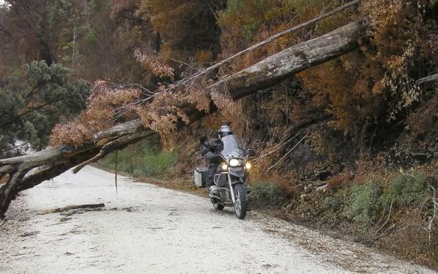
Anyhow, we travelled 70KM in total before we were turned back by a log that was a little too big to move by hand.
Only 8 km to go and I am in Corinna (assuming the road "block" at the other end was equally as unrestrictive), but here's what I found...
A few sections of the road that have large trees damaged by fire.
NO evidence at all that any work is being carried out to re-open this road.
If I had my chainsaw it would have stopped me for less than 5 minutes.
So we turned back and went to Sumac Lookout on the Arthur River Forest Drive - this wonderful drive, travelling through about all that is left of the Tarkine with the forestry operations clearly visible in Google satellite inages.
Here, at Sumac Lookout, is a sign indicating the Tayatea bridge was washed away in August 2007 and has not been replaced. So the Arthur River forest drive is a no through road - you would need to drive all the way to the bridge if you went the way we did had it not been for the sign we saw at Sumac Lookout, which you need to stop to notice.
So we turned around and continued toward Trowutta. (great names they've got out there).
Here we saw signs indicating the Tayatea bridge is closed.
So we came home, happy that we now know we won't be spending a week at the Tarkine or at Arthur River.
A couple of days ago I went to the Stanley Visitor Information Centre. I asked them about the Tarkine. They said "What would you like to know".
I initially asked about the Western Explorer. They said it was closed and that Parks are going to put to tender to have the burnt trees removed.
No idea when.
Then I asked about the Tayatea bridge, she said it was closed since the bridge was washed away in August 2007, but you can still get to all areas by going in from both ends.
I then asked about the Tarkine - what areas are publicly accessible. She said the Western Explorer and the Arthur River Forest Drive.
I said apart from those roads, what areas of the Tarkine are accessible to the public. She said that's it.
I thanked her and left.
If you have a look with Google's satellite images at the amount of logging that is going on around the Tarkine, any wonder there is nothing else that's accessible.
It is Forestry that is responsible for this bridge. I guess they don't need it to get any logs out from there.
My bet is that if they did, it wouldn't have been absent for 11 months (and counting).
I wonder why work STILL hasn't started on the Western Explorer? Or why Parks Tas (according to Stanley Visitor Centre) are charged with arranging to make this road safe.
Perhaps our state Infrastructure minister has some questions to answer.
Now, there has been a bit of talk of the Western Explorer being "closed until further notice". So I decided to call into Smithton on the way, to get the lowdown on what the go is.
There is no visitor centre in Smithton and the suggestion was put to me to go to Stanley to go to the Visitor Centre for "information like that".
I went to the Circular Head Council building to have a chat with them instead. They sent me upstairs where a most helpful lady found a piece of paper that had a printout of some release saying that it was indeed closed until further notice, but that the note was dated April, and she had no further information.
So she has my email address and mobile number, she will find out what's going on and get back to me.
9 days later, still waiting.
No big deal. Continue on to Arthur River. All the road signs are still indicating Arthur River, Zeehan etc, with no indication that the Western Explorer road was closed.
Arthur river is definitely off season at the moment - even the shop was closed. There is a Parks office we went to - a sliding glass door that is always unlocked, gains you access to a small room filled with information on such things as 4WD'ing the west coast, paying to use the parks via the honesty box etc. And as you look around, you spot an A4 sized piece of paper that contains information saying the Western Explorer is closed until further notice. Also dated April 08.
And if I hadn't gone into the Parks office?
We continued south from Arthur River and get to the Western Explorer. The sign says Corinna 78 KM. But there are a couple of Road Closed signs across the road, spaced such that it is easy to drive around them without leaving the road. Interesting that if we hadn't stopped at the Parks office and spotted the notice, we wouldn't have known about the road being closed until we got here.
So we went around them and continued on.
We came to the Balfour Track, approx 5 or so KM down the Western Explorer.
Here, there is a bit more of an effort to stop the traffic - the Road Closed signs extend across the road, bolted to star pickets that are solid, but for a section of the road that is blocked by a pile of gravel heaped on the road.
With a bit of careful consideration, I was able to negotiate the Toyota Corolla non-4WD vehicle over the gravel and continue.
Stopped on a high point to phone someone and let them know where we are "just in case".
Yes, a Next-G phone works on several high points of the Western Explorer, even though there are signs saying "no mobile phone coverage". I guess that's to add to the wilderness "feel" of this road.
Anyhow, we travelled 70KM in total before we were turned back by a log that was a little too big to move by hand.
Only 8 km to go and I am in Corinna (assuming the road "block" at the other end was equally as unrestrictive), but here's what I found...
A few sections of the road that have large trees damaged by fire.
NO evidence at all that any work is being carried out to re-open this road.
If I had my chainsaw it would have stopped me for less than 5 minutes.
So we turned back and went to Sumac Lookout on the Arthur River Forest Drive - this wonderful drive, travelling through about all that is left of the Tarkine with the forestry operations clearly visible in Google satellite inages.
Here, at Sumac Lookout, is a sign indicating the Tayatea bridge was washed away in August 2007 and has not been replaced. So the Arthur River forest drive is a no through road - you would need to drive all the way to the bridge if you went the way we did had it not been for the sign we saw at Sumac Lookout, which you need to stop to notice.
So we turned around and continued toward Trowutta. (great names they've got out there).
Here we saw signs indicating the Tayatea bridge is closed.
So we came home, happy that we now know we won't be spending a week at the Tarkine or at Arthur River.
A couple of days ago I went to the Stanley Visitor Information Centre. I asked them about the Tarkine. They said "What would you like to know".
I initially asked about the Western Explorer. They said it was closed and that Parks are going to put to tender to have the burnt trees removed.
No idea when.
Then I asked about the Tayatea bridge, she said it was closed since the bridge was washed away in August 2007, but you can still get to all areas by going in from both ends.
I then asked about the Tarkine - what areas are publicly accessible. She said the Western Explorer and the Arthur River Forest Drive.
I said apart from those roads, what areas of the Tarkine are accessible to the public. She said that's it.
I thanked her and left.
If you have a look with Google's satellite images at the amount of logging that is going on around the Tarkine, any wonder there is nothing else that's accessible.
It is Forestry that is responsible for this bridge. I guess they don't need it to get any logs out from there.
My bet is that if they did, it wouldn't have been absent for 11 months (and counting).
I wonder why work STILL hasn't started on the Western Explorer? Or why Parks Tas (according to Stanley Visitor Centre) are charged with arranging to make this road safe.
Perhaps our state Infrastructure minister has some questions to answer.