Forum rules
NSW & ACT specific bushwalking discussion. Please avoid publishing details of access to sensitive areas with no tracks.Faulconbridge to Blaxland
Sat 04 Jul, 2015 10:09 pm
Hi,
I was hoping someone could help clear something up for me.
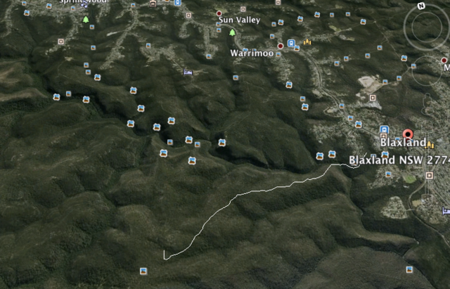
I am looking to walk from Faulconbridge, to Blaxland. I have been reading the track notes on http://www.wildwalks.com/bushwalking-an ... xland.html However, my map does not have the entire route showing; I have outlined the route on google earth that is missing.

My confusion comes from the track notes saying to follow "St Helenas Ridge" but on my map St Helenas Ridge is further to the south, ending me up towards Glenbrook.
Is there an actual trail there, or does it require bushbashing? I was able to locate the trail further to the south on google earth, but was not able to locate this one.
Any help would be appreciated.
I was hoping someone could help clear something up for me.
I am looking to walk from Faulconbridge, to Blaxland. I have been reading the track notes on http://www.wildwalks.com/bushwalking-an ... xland.html However, my map does not have the entire route showing; I have outlined the route on google earth that is missing.

My confusion comes from the track notes saying to follow "St Helenas Ridge" but on my map St Helenas Ridge is further to the south, ending me up towards Glenbrook.
Is there an actual trail there, or does it require bushbashing? I was able to locate the trail further to the south on google earth, but was not able to locate this one.
Any help would be appreciated.
Re: Faulconbridge to Blaxland
Sun 05 Jul, 2015 12:24 am
Have a look at -
http://www.david-noble.net/blog/?p=5662
I describe a track from the St Helena Ridge to Glenbrook Ck - where you meet the track that descends from Pippas Pass - Florabella Pass track. It is easy walking along a reasonable track. It is marked on open street maps.
Dave
http://www.david-noble.net/blog/?p=5662
I describe a track from the St Helena Ridge to Glenbrook Ck - where you meet the track that descends from Pippas Pass - Florabella Pass track. It is easy walking along a reasonable track. It is marked on open street maps.
Dave
Re: Faulconbridge to Blaxland
Sun 05 Jul, 2015 5:43 am
Awesome thanks heaps for that!
Still new to this so forget about all the sites such as OpenStreetMaps, which I will need to save for future references
Still new to this so forget about all the sites such as OpenStreetMaps, which I will need to save for future references
Re: Faulconbridge to Blaxland
Wed 08 Jul, 2015 5:29 pm
I'd err on the side of caution with this walk at the moment. The track is VERY messy after I'm assuming the wild weather of past months. Lots of trees down, and branches everywhere making following the track difficult at times. I think the section from Bunyan lookout, along St Helenas ridge and down to Pippas pass was really lovely walking. I'll do a further trip report later
Re: Faulconbridge to Blaxland
Thu 16 Jul, 2015 11:35 pm
http://www.openstreetmap.org/#map=15/-33.7446/150.5950
The track you want is clearly marked in OSM, easy to find on the ground, and easy to follow on the ridge...
Enjoy.
The track you want is clearly marked in OSM, easy to find on the ground, and easy to follow on the ridge...
Enjoy.
© Bushwalk Australia and contributors 2007-2013.
