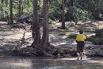
Just an update - Horse Track opened a few weeks back. The track maintenence crew have done the steeper pass section around the gate and are slowly making their way down the more gentle parts, but it's all been brushcut and is an easy walk, the steps they've done so far are top notch, too.
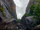
Speaking to people in the know recently - and I have been hearing the same for a few years - NPWS will basically make Horse Track the advertised way in and encourage people to use it as a main route to Acacia Flat. They are leaving the Williams track (from Govetts lookout to Junction rock via the base of the falls) alone for a good while due to landslide risk, although it's interesting to note that the new valley floor signage has directions, even though there is very clear "track closed" stuff up at Junction Rock. So it's "never say never" on that part. However the Rodriguez pass up Greaves Creek to the Grand Canyon will never re-open. In particular the section pictured at the top of the page has completely dropped away, leaving the cable rail floating in mid-air.
Rodriguez Pass @ Blackheath now open
Forum rules
NSW & ACT specific bushwalking discussion. Please avoid publishing details of access to sensitive areas with no tracks.
NSW & ACT specific bushwalking discussion. Please avoid publishing details of access to sensitive areas with no tracks.
47 posts
• Page 2 of 2 • 1, 2
Re: Rodriguez Pass @ Blackheath now open
![]() by marron » Tue 23 Apr, 2024 11:43 am
by marron » Tue 23 Apr, 2024 11:43 am
-
marron - Atherosperma moschatum

- Posts: 77
- Joined: Sun 16 Jan, 2022 10:29 am
- Region: New South Wales
Re: Rodriguez Pass @ Blackheath now open
![]() by johnw » Tue 23 Apr, 2024 1:28 pm
by johnw » Tue 23 Apr, 2024 1:28 pm
Interesting. Sounds like the Govetts track isn't 100% never.
Watch this space I guess. I'm keen to revisit the Horse track when I'm fitter health-wise. It has always been the least difficult route into the valley. Interested to see what they've done with it. Shame Rodriguez Pass is no more. My favourite short loop was Horse, Rodriguez, Grand Canyon. One of the most stunning walks in the mountains. I'll cherish my photos (and memories) even more now.
Watch this space I guess. I'm keen to revisit the Horse track when I'm fitter health-wise. It has always been the least difficult route into the valley. Interested to see what they've done with it. Shame Rodriguez Pass is no more. My favourite short loop was Horse, Rodriguez, Grand Canyon. One of the most stunning walks in the mountains. I'll cherish my photos (and memories) even more now.
John W
In Nature's keeping they are safe, but through the agency of man destruction is making rapid progress - John Muir c1912
In Nature's keeping they are safe, but through the agency of man destruction is making rapid progress - John Muir c1912
-
johnw - Lagarostrobos franklinii

- Posts: 9690
- Joined: Wed 23 Jan, 2008 11:59 am
- Location: Macarthur Region - SW Sydney
- Region: New South Wales
- Gender: Male
Re: Rodriguez Pass @ Blackheath now open
![]() by marron » Tue 23 Apr, 2024 1:38 pm
by marron » Tue 23 Apr, 2024 1:38 pm
Yep, it seems they are keen to open the Govetts descent eventually, but there was a rockfall scare not that long ago near workers so it's wait and see I guess.
Agreed on Rodriguez, a stunning one - all those falls. I assume people will still visit them, but I think it will be sketchier the further you go up the old track. I can remember just below Beauchamp it was always a little tricky to find your way through all the boulders and I'd imagine there's a fair few new ones in that bit.
Agreed on Rodriguez, a stunning one - all those falls. I assume people will still visit them, but I think it will be sketchier the further you go up the old track. I can remember just below Beauchamp it was always a little tricky to find your way through all the boulders and I'd imagine there's a fair few new ones in that bit.
-
marron - Atherosperma moschatum
- Posts: 77
- Joined: Sun 16 Jan, 2022 10:29 am
- Region: New South Wales
Re: Rodriguez Pass @ Blackheath now open
![]() by keithj » Tue 23 Apr, 2024 6:32 pm
by keithj » Tue 23 Apr, 2024 6:32 pm
[quote="Avidbushwalker"Thank you again for the update. Feel free to let me know when you notice any changes.[/quote]
Not much has changed since 2021...
Rodriguez is extremely unlikey to ever be reopened - extremely dangerous.
Horsetrack is re-opened & is now easily navigable - it will be the preferred way into that end of the valley. The track builders are still working there during the week (at least another 3 months work on the lower slopes)- they've done an excellent job soo far. It's a much better track than prior to 2020.
Govetts/Williams Track still has lots of unopened white bags of material, work was about to start before the last rain event, but that now has to wait a few weeks until things stabilise. There is a significant landslide halfway down that looks like it reaches the Jungle Track turnoff.
I went down Horsetrack & up Perrys the day it reopened. It's nice not to see footprints until I met a couple of suprised rangers coming down Perrys.
The bit just past the gate is all steps - very narrow, steep for short sections, but solid.
The Creek was down at normal levels, but there was plenty of evidence that is was 3m higher. This was maybe a week after the recent rains.
It had been way over the track level - there was a little erosion and some sinkholes. The whole track is slashed for meter either side - it's mostly runnable for those so inclined.
And there are a couple of new deviations downstream from Junction Rock, that climb 30m above the creek, avoiding the lowest lying and easily flooded & eroded sections.
So next time NPWS closes the park due to impending rains, just have a look at how high the debris can get
And as a bonus keep an eye for the 2m Diamond Python lurking on the level section halfway down Horsetrack.
- keithj
- Athrotaxis cupressoides

- Posts: 307
- Joined: Sun 01 Nov, 2015 7:27 pm
- Region: New South Wales
- Gender: Male
Re: Rodriguez Pass @ Blackheath now open
![]() by marron » Wed 24 Apr, 2024 8:53 am
by marron » Wed 24 Apr, 2024 8:53 am
Nice, thanks Keith!
I also went down the day it opened haha. Took my son and we camped at...well... near... perhaps... Syncarpia Missed the python though!
Also spent a few days camping at Acacia Flat recently; yes, the water level had got pretty high in places - and has removed the log that crosses the creek to Shortridge/Lockleys from it's "new" position, pushing it to one side completety - gotta get your feet wet to cross now
And yes some deviations in that section from Junction to Acacia - the flood damage in 2021 was also pretty severe and had made those parts pretty unstable so the track goes up the slope further now.
I also went down the day it opened haha. Took my son and we camped at...well... near... perhaps... Syncarpia
Also spent a few days camping at Acacia Flat recently; yes, the water level had got pretty high in places - and has removed the log that crosses the creek to Shortridge/Lockleys from it's "new" position, pushing it to one side completety - gotta get your feet wet to cross now
And yes some deviations in that section from Junction to Acacia - the flood damage in 2021 was also pretty severe and had made those parts pretty unstable so the track goes up the slope further now.
-
marron - Atherosperma moschatum
- Posts: 77
- Joined: Sun 16 Jan, 2022 10:29 am
- Region: New South Wales
Re: Rodriguez Pass @ Blackheath now open
![]() by marron » Sun 25 Aug, 2024 8:48 pm
by marron » Sun 25 Aug, 2024 8:48 pm
Just a word of warning folks - just read about a rescue near Beauchamp falls over night. It's sketchy as hell through there. I've had a little bit of a poke around from below and it's just not good, landslides, loose ground at height. Up top, even worse, as described up thread.
Now I don't know what happened last night, but, I happened to be camped down near the creek junction with my kids and we were there all arvo with a brief jaunt up the creek for an hour or so around 5PM. No-one came through at all, which suggests to me that these walkers attempted going down Rodriguez from the top - beggars belief a bit, but at least they had a PLB I suppose. It's possible we just missed them I guess, or they were making a day of it and only called it in at night? I don't know. Either way... really best avoided.
On a side note, we encountered the diamond python
-
marron - Atherosperma moschatum
- Posts: 77
- Joined: Sun 16 Jan, 2022 10:29 am
- Region: New South Wales
Re: Rodriguez Pass @ Blackheath now open
![]() by Xplora » Mon 26 Aug, 2024 6:48 am
by Xplora » Mon 26 Aug, 2024 6:48 am
marron wrote:Just a word of warning folks - just read about a rescue near Beauchamp falls over night. It's sketchy as hell through there. I've had a little bit of a poke around from below and it's just not good, landslides, loose ground at height. Up top, even worse, as described up thread.
Now I don't know what happened last night, but, I happened to be camped down near the creek junction with my kids and we were there all arvo with a brief jaunt up the creek for an hour or so around 5PM. No-one came through at all, which suggests to me that these walkers attempted going down Rodriguez from the top - beggars belief a bit, but at least they had a PLB I suppose. It's possible we just missed them I guess, or they were making a day of it and only called it in at night? I don't know. Either way... really best avoided.
On a side note, we encountered the diamond python
Possible also it was related to Pilcher canyon which exits at the falls.
- Xplora
- Athrotaxis selaginoides

- Posts: 1671
- Joined: Sat 01 Aug, 2015 7:24 am
- Region: Victoria
- Gender: Male
Re: Rodriguez Pass @ Blackheath now open
![]() by marron » Mon 26 Aug, 2024 11:48 am
by marron » Mon 26 Aug, 2024 11:48 am
Yes i read in another report today they walked out so that would nake sense!
-
marron - Atherosperma moschatum
- Posts: 77
- Joined: Sun 16 Jan, 2022 10:29 am
- Region: New South Wales
Re: Rodriguez Pass @ Blackheath now open
![]() by YoungCodger » Mon 25 Nov, 2024 9:26 am
by YoungCodger » Mon 25 Nov, 2024 9:26 am
I've also heard from Parks workers that it is extremely unlikely that Rodriguez Pass will re-open, given how many potential landslides there are waiting to happen. Too sketchy.
-
YoungCodger - Nothofagus gunnii

- Posts: 44
- Joined: Mon 10 Feb, 2020 7:12 pm
- Region: New South Wales
- Gender: Male
Re: Rodriguez Pass @ Blackheath now open
![]() by marron » Mon 25 Nov, 2024 2:55 pm
by marron » Mon 25 Nov, 2024 2:55 pm
Hoofed a circuit on Saturday from Evans lookout round to Perrys via Govetts Leap then down and along the valley floor and back up the horse track. The work is still a zig zag or two away from reaching the bottom. I tell you what though, those steps make a difference. Barely raised a sweat coming out (.... I wish haha).
-
marron - Atherosperma moschatum
- Posts: 77
- Joined: Sun 16 Jan, 2022 10:29 am
- Region: New South Wales
Re: Rodriguez Pass @ Blackheath now open
![]() by oliverd » Sat 11 Jan, 2025 8:54 pm
by oliverd » Sat 11 Jan, 2025 8:54 pm
I'm a bit baffled by some of the comments re: Rodriguez Pass. I understand the Govetts Leap end / Govetts Leap track is pretty badly damaged and dangerous - I haven't personally explored this section for a long time.
But the track along Greaves Creek is in great condition and has no sketchy sections (if you take the route along the creek just above Beauchamp Falls, and avoid the section that has a steel hand-line across a landslip).
Did this a couple of weeks ago as an "out and back walk" - I would have gone down Rodriguez Pass and up Horse Track, but I full expected I'd get to a sketchy section and have to turm back!
https://hikingtheworld.blog/2025/01/11/pilcher-point-rodriguez-pass/
Really not sure why Beauchamp Falls to Govetts Creek is closed, other than the risk of potential/future landslips.
- oliverd
- Nothofagus cunninghamii

- Posts: 4
- Joined: Wed 31 Dec, 2014 11:36 pm
- Region: New South Wales
- Gender: Male
Re: Rodriguez Pass @ Blackheath now open
![]() by marron » Sun 12 Jan, 2025 6:42 am
by marron » Sun 12 Jan, 2025 6:42 am
It's the landslide part, and risk of more.
I've looked at it from the top and noped out, on my own, just didnt want to trust that surface especially knowing it had once been solid looking path - had no idea there was alternate route though!
When i last had a look around from the other direction there was fresh landslide above one of those lower falls, soft and loose at height, which again caused me to back out. Being on my own with the rangers words about geological.assessments ringing in my ears was enough i guess!
I had started to hear of people doing it though and wondered about the landslip bit. That theres another way is good to know.
-
marron - Atherosperma moschatum
- Posts: 77
- Joined: Sun 16 Jan, 2022 10:29 am
- Region: New South Wales
Re: Rodriguez Pass @ Blackheath now open
![]() by keithj » Sun 12 Jan, 2025 2:24 pm
by keithj » Sun 12 Jan, 2025 2:24 pm
oliverd wrote:I'm a bit baffled by some of the comments re: Rodriguez Pass. I understand the Govetts Leap end / Govetts Leap track is pretty badly damaged and dangerous - I haven't personally explored this section for a long time.
But the track along Greaves Creek is in great condition and has no sketchy sections (if you take the route along the creek just above Beauchamp Falls, and avoid the section that has a steel hand-line across a landslip).
...
Really not sure why Beauchamp Falls to Govetts Creek is closed, other than the risk of potential/future landslips.
Sure - it's still doable. However, the reason it is closed is the geological instability - both landslips and rockfalls.
The reason it was closed prior to 2010 is unstable blocks fell from a height onto the track - including this 200 ton boulder fell smack on the track opposite the arrow.
There were also multiple landslips. The result was that NPWS installed the alternate route with the cable & star pickets.
In early 2020 another big rain event caused more landslips, including washing out the new cable route.
I & other have explored from below. There are 8-12 landslips in the steeper section towards the rockfall area - mostly minor. However, there are a couple above significant drops and a couple that have ropes installed.
There is fresh rock in multiple places along the track that has fallen from a height.
Looking at the cliff faces on both sides it's mostly freshly exposed rock - a sure sign of instability.
So two major incidents with high probability of death in 3,600 days.
And judging by the fresh rocks & unvegetated landslips there are frequent more minor incidents.
Based on that, NPWS have made the call to close it.
- keithj
- Athrotaxis cupressoides
- Posts: 307
- Joined: Sun 01 Nov, 2015 7:27 pm
- Region: New South Wales
- Gender: Male
Re: Rodriguez Pass @ Blackheath now open
![]() by oliverd » Sun 12 Jan, 2025 8:12 pm
by oliverd » Sun 12 Jan, 2025 8:12 pm
@marron someone told me about the alternate track - based on the condition of the steel railings it's been there for a few decades. It completely avoids the topmost landslide area.
@keithj your feedback makes sense; wish there was a bit more transparency by NPWS. Track "closed due to rockfalls and landslides" is different to closing a track due to an elevated risk of rockfalls/landslides.
@keithj your feedback makes sense; wish there was a bit more transparency by NPWS. Track "closed due to rockfalls and landslides" is different to closing a track due to an elevated risk of rockfalls/landslides.
- oliverd
- Nothofagus cunninghamii
- Posts: 4
- Joined: Wed 31 Dec, 2014 11:36 pm
- Region: New South Wales
- Gender: Male
Re: Rodriguez Pass @ Blackheath now open
![]() by Avidbushwalker » Fri 17 Jan, 2025 12:10 pm
by Avidbushwalker » Fri 17 Jan, 2025 12:10 pm
Hello All,
Thank you for all the detailed updates, most appreciated.
I have used the Horse Track on a number of different occasions since it has reopened, a couple times down to Junction Rock and a couple times from Perrys and up the Horse Track. Great to see they're slowly making progress on the Horse Track as at December when I went down there on two occasions. They've got a person counter near the top of the Horse Track!
I too have seen the diamond python between Junction and the bottom of Horse but it was mostly hidden. Quite exciting to see one ! I did see another baby snake down there on a separate time but not 100% what kind it was.
Has anyone heard if the Govetts Leap descent has stablised/similar so works can recommence? As far as I understand majority of the works were on the descent section to the base of the falls? Has any one heard of the current track condition from the base of the falls to Junction Rock? Would love to see photos of its current status as it may be fine to do?
Thank you.
Last edited by Avidbushwalker on Fri 17 Jan, 2025 1:04 pm, edited 1 time in total.
- Avidbushwalker
- Nothofagus gunnii
- Posts: 44
- Joined: Sat 18 Dec, 2021 10:30 pm
- Region: New South Wales
Re: Rodriguez Pass @ Blackheath now open
![]() by Avidbushwalker » Fri 17 Jan, 2025 12:23 pm
by Avidbushwalker » Fri 17 Jan, 2025 12:23 pm
keithj wrote:oliverd wrote:I'm a bit baffled by some of the comments re: Rodriguez Pass. I understand the Govetts Leap end / Govetts Leap track is pretty badly damaged and dangerous - I haven't personally explored this section for a long time.
But the track along Greaves Creek is in great condition and has no sketchy sections (if you take the route along the creek just above Beauchamp Falls, and avoid the section that has a steel hand-line across a landslip).
...
Really not sure why Beauchamp Falls to Govetts Creek is closed, other than the risk of potential/future landslips.
Sure - it's still doable. However, the reason it is closed is the geological instability - both landslips and rockfalls.
The reason it was closed prior to 2010 is unstable blocks fell from a height onto the track - including this 200 ton boulder fell smack on the track opposite the arrow.
There were also multiple landslips. The result was that NPWS installed the alternate route with the cable & star pickets.
In early 2020 another big rain event caused more landslips, including washing out the new cable route.
I & other have explored from below. There are 8-12 landslips in the steeper section towards the rockfall area - mostly minor. However, there are a couple above significant drops and a couple that have ropes installed.
There is fresh rock in multiple places along the track that has fallen from a height.
Looking at the cliff faces on both sides it's mostly freshly exposed rock - a sure sign of instability.
So two major incidents with high probability of death in 3,600 days.
And judging by the fresh rocks & unvegetated landslips there are frequent more minor incidents.
Based on that, NPWS have made the call to close it.
Hey Keith. Thank you for giving a detailed insight into the first incident prior to 2010. The 200T boulder is ginormous!!! I guess they waited at that time for it to stablise before putting in the cable rail.
And thank you for the update and photo with the rope from your reasonably recent walk down there.
The frequency as you mention is quite often...the section with the cable barely lasted 10 years!
Out of curiosity, do you have any photos you could share of Rodriguez in it's heyday? Ive got one other question too. Can i dm you ?
Thanks.
- Avidbushwalker
- Nothofagus gunnii
- Posts: 44
- Joined: Sat 18 Dec, 2021 10:30 pm
- Region: New South Wales
Re: Rodriguez Pass @ Blackheath now open
![]() by marron » Sat 18 Jan, 2025 8:44 am
by marron » Sat 18 Jan, 2025 8:44 am
David Noble's blog has a lot of photos of Rodriguez pass, a quick google should find them, let me know if you can't. (Of course Heyday to me also could mean those 19th century types with picnic baskets... theres a few on flickr and in various books and things)
I know people who have recently walked up to the falls from junction rock and they didnt report anything amiss. Don't know about when work might commence though.
I know people who have recently walked up to the falls from junction rock and they didnt report anything amiss. Don't know about when work might commence though.
-
marron - Atherosperma moschatum
- Posts: 77
- Joined: Sun 16 Jan, 2022 10:29 am
- Region: New South Wales
47 posts
• Page 2 of 2 • 1, 2
Return to New South Wales & ACT
Who is online
Users browsing this forum: No registered users and 89 guests