Page 1 of 3

Interesting side track on Cowan to Brooklyn section of GNW

PostPosted: Wed 10 Jul, 2013 8:16 pm
by davidfisher71
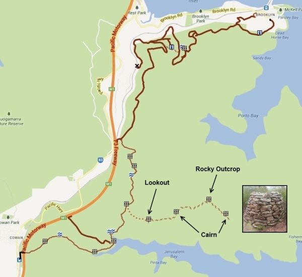
I did the Cowan to Brooklyn section of the Great North Walk yesterday, and came across a side track that eventually led first to a lookout, then a cairn, then a rocky outcrop with a beautiful 360 degree view, then another cairn. I was wondering if anyone knows the history of this area (the reason for the two cairns), and whether the rocky outcrop has a name. I would name it "Tortoise Rock" if I had to choose, because of its shape the interesting pattern.

Some locations if it helps:

Start of track -33 35' 01", 151 11 43" (heading west)
Lookout -33 35' 11", 151 12' 01" (track becomes a bit overgrown after this point)
First cairn -33 35' 06", 151 12' 23"
Rocky outcrop -33 34' 57", 151 12' 50"
Second cairn -33 35' 08", 151 13' 03"

The track starts just behind a sign saying "Jerusalem Bay ->" and "<- Brooklyn Dam".

Thanks for any help!

EDIT: Here's a map with the side track shown.
Image

Re: Interesting side track on Cowan to Brooklyn section of G

PostPosted: Thu 11 Jul, 2013 6:15 am
by Rob Gosford
hi David,
i think that track is known as Taffys Rock track (not sure tho). You might like to Google "Taffys Rock" to get some more info and history.

:)

Re: Interesting side track on Cowan to Brooklyn section of G

PostPosted: Thu 11 Jul, 2013 7:46 am
by perfectlydark
Wish I knew this a week ago lol

Re: Interesting side track on Cowan to Brooklyn section of G

PostPosted: Thu 11 Jul, 2013 9:14 am
by michael_p

Re: Interesting side track on Cowan to Brooklyn section of G

PostPosted: Thu 11 Jul, 2013 9:15 am
by davidfisher71
Rob Gosford wrote:hi David,
i think that track is known as Taffys Rock track (not sure tho). You might like to Google "Taffys Rock" to get some more info and history.

Thank you for that. A search here mentions that Taffy's Rock is at -33.58504,+151.22798, which is about 1 km further east than I went -- I originally stopped soon after the second cairn, but the track continues on after all. Maybe another time!

"Taffy" is the nickname of Dorothy Townson; she has a plaque at Taffy's Rock.

The rocky outcrop I mentioned may be called Mackeral Rock.

I found a page showing a GPS track that goes all the way to the end:

http://www.bushclub.org.au/PhotoPages/Ku-ring-gaiNPCowanTaffysRockAp12.htm

Image

Re: Interesting side track on Cowan to Brooklyn section of G

PostPosted: Thu 11 Jul, 2013 9:22 am
by davidfisher71

Thanks Michael. It's a beautiful area, but the track gets a bit overgrown!

Re: Interesting side track on Cowan to Brooklyn section of G

PostPosted: Thu 11 Jul, 2013 9:24 am
by kanangra
Gee the things you learn. Never knew that. Very interesting. Must pay that a visit.

K.

Re: Interesting side track on Cowan to Brooklyn section of G

PostPosted: Thu 11 Jul, 2013 11:52 am
by forest
Nice one. I'll have a quick run in there next time I'm coming home from Sydney.
Great find and thanks for posting up the info

Re: Interesting side track on Cowan to Brooklyn section of G

PostPosted: Thu 11 Jul, 2013 3:19 pm
by michael_p
Little more info.

OSM has the Taffys Track and the Campbells Crater Track: http://www.openstreetmap.org/?lat=-33.58123540878296&lon=151.1920666694641&zoom=16. I have read of people using the Campbells Crater track as a shortcut for the Taffys Track. Not sure about parking on the F3 though. I have also read of a risky shortcut that uses a tunnel (most likely a drain) under the F3 from the Pacific Highway but I have no idea where this is.

Cliff Trig (past Taffys) apparently has a logbook. Trig location: http://goo.gl/maps/Xev0N.

Michael.

Re: Interesting side track on Cowan to Brooklyn section of G

PostPosted: Thu 11 Jul, 2013 4:52 pm
by DaveNoble
There is also an article in the Bushwalker (page 15) -

http://www.bushwalkermagazine.org/the%2 ... ker263.pdf

Dave

Re: Interesting side track on Cowan to Brooklyn section of G

PostPosted: Fri 12 Jul, 2013 10:44 am
by Rob Gosford
DaveNoble wrote:There is also an article in the Bushwalker (page 15) -

http://www.bushwalkermagazine.org/the%2 ... ker263.pdf

Dave


thanks for that www link Dave. it would be interesting to suss this track out 8)

I wonder if WildWalks could do track notes on this walk sometime in the future ? :P

Re: Interesting side track on Cowan to Brooklyn section of G

PostPosted: Wed 17 Jul, 2013 7:10 pm
by Lindsay
After reading this thread, and having a day off today, I decided to check this track out. Unfortunately I had no topo map, so I used the printout shown on the post above. (the track's not marked on the topo anyway) It was a nice 2 hour walk from the GNW junction, the track being nice and clear up to the lookout, but became very overgrown and hard to find in some places after that, the two large cairns being almost invisible until right on top of them. Problem was, I couldn't find the memorial plaque that is meant to be somewhere on the rock, which is a very large platform with lots of nooks and crannies. After searching for over half an hour I gave it up and just enjoyed the view instead. I did notice another large cairn on a ledge just to the west of the main rock, but I didn't investigate as the undergrowth was horrendously thick and I was running out of time to be back before dark.

A very nice walk, but I would really have liked to have found the memorial.

Re: Interesting side track on Cowan to Brooklyn section of G

PostPosted: Wed 17 Jul, 2013 8:00 pm
by GPSGuided
michael_p wrote:I have read of people using the Campbells Crater track as a shortcut for the Taffys Track. Not sure about parking on the F3 though. I have also read of a risky shortcut that uses a tunnel (most likely a drain) under the F3 from the Pacific Highway but I have no idea where this is.

That may explain why there's the occasional "abandoned" car on the F3. Have always wondered what weirdo would leave their apparently functioning car by the freeway. Not so weird after all.

Taking a closer look on street view, there's actually a small emergency parking bay.
http://goo.gl/maps/8K5U3

Re: Interesting side track on Cowan to Brooklyn section of G

PostPosted: Wed 17 Jul, 2013 8:07 pm
by GPSGuided
Great info guys. I've just entered the correct label for this track in OSM. No more confusion for future walkers.

Re: Interesting side track on Cowan to Brooklyn section of G

PostPosted: Wed 17 Jul, 2013 9:18 pm
by michael_p
GPSGuided wrote:...I've just entered the correct label for this track in OSM...

Great idea. Thank you.

Re: Interesting side track on Cowan to Brooklyn section of G

PostPosted: Wed 17 Jul, 2013 9:24 pm
by michael_p
Lindsay wrote:...Problem was, I couldn't find the memorial plaque that is meant to be somewhere on the rock, which is a very large platform with lots of nooks and crannies. After searching for over half an hour I gave it up and just enjoyed the view instead...

Have a look at this set of photos: http://grindlay.org/bushwalking/20110924_taffys_photos.html. It appears to be on the side of the platform.

Cheers,
Michael.

Re: Interesting side track on Cowan to Brooklyn section of G

PostPosted: Wed 17 Jul, 2013 10:42 pm
by Rob Gosford
GPSGuided wrote:
michael_p wrote:I have read of people using the Campbells Crater track as a shortcut for the Taffys Track. Not sure about parking on the F3 though. I have also read of a risky shortcut that uses a tunnel (most likely a drain) under the F3 from the Pacific Highway but I have no idea where this is.

That may explain why there's the occasional "abandoned" car on the F3. Have always wondered what weirdo would leave their apparently functioning car by the freeway. Not so weird after all.

Taking a closer look on street view, there's actually a small emergency parking bay.
http://goo.gl/maps/8K5U3


"Taking a closer look on street view, there's actually a small emergency parking bay.
http://goo.gl/maps/8K5U3"


that GoogleMap photo of that parking bay GPS, is the Jerusalem Bay Firetrail which takes you down to Jerusalem Bay and the lone palm tree, linking up with the GNW. The "Campbells Crater track F3 Parking Bay" is about 930 meters before that parking bay.

cheers 8)

Re: Interesting side track on Cowan to Brooklyn section of G

PostPosted: Wed 17 Jul, 2013 11:17 pm
by GPSGuided
Rob Gosford wrote:that GoogleMap photo of that parking bay GPS, is the Jerusalem Bay Firetrail which takes you down to Jerusalem Bay and the lone palm tree, linking up with the GNW. The "Campbells Crater track F3 Parking Bay" is about 930 meters before that parking bay

That's correct. I did search for an earlier entry point but note the emergency phone spot at the start of Campbells Crater track didn't offer much room off the breakdown lane. Didn't think it'd be wise to park for a day at that spot. This one at the Jerusalem Bay Firetrail seemed to offer more safety, hence the link.

What I am not sure about is, are we allowed to use these emergency bays to park our vehicles for walks? It would not be nice if we come back to an infringement notice from the regular highway patrols on that section.

Re: Interesting side track on Cowan to Brooklyn section of G

PostPosted: Wed 17 Jul, 2013 11:27 pm
by michael_p
GPSGuided wrote:What I am not sure about is, are we allowed to use these emergency bays to park our vehicles for walks? It would not be nice if we come back to an infringement notice from the regular highway patrols on that section.

Doesn't look like it: http://www.legislation.nsw.gov.au/maintop/view/inforce/subordleg+179+2008+cd+0+N. But I could be wrong.

Cheers,
Michael.

Re: Interesting side track on Cowan to Brooklyn section of G

PostPosted: Wed 17 Jul, 2013 11:42 pm
by Lindsay
michael_p wrote:
Lindsay wrote:...Problem was, I couldn't find the memorial plaque that is meant to be somewhere on the rock, which is a very large platform with lots of nooks and crannies. After searching for over half an hour I gave it up and just enjoyed the view instead...

Have a look at this set of photos: http://grindlay.org/bushwalking/20110924_taffys_photos.html. It appears to be on the side of the platform.

Cheers,
Michael.


Thanks for that Michael, still can't identify the spot though :?

Re: Interesting side track on Cowan to Brooklyn section of G

PostPosted: Thu 18 Jul, 2013 12:43 am
by michael_p
Lindsay wrote:
michael_p wrote:
Lindsay wrote:...Problem was, I couldn't find the memorial plaque that is meant to be somewhere on the rock, which is a very large platform with lots of nooks and crannies. After searching for over half an hour I gave it up and just enjoyed the view instead...

Have a look at this set of photos: http://grindlay.org/bushwalking/20110924_taffys_photos.html. It appears to be on the side of the platform.

Cheers,
Michael.


Thanks for that Michael, still can't identify the spot though :?


I've found some coordinates for the plaque for future reference: S33 35.115 E151 13.719. It appears to be off to the side a bit, looking at the location it could easily be missed.

Re: Interesting side track on Cowan to Brooklyn section of G

PostPosted: Thu 18 Jul, 2013 7:38 am
by perfectlydark
Probably just easier to walk from cowan?

Re: Interesting side track on Cowan to Brooklyn section of G

PostPosted: Thu 18 Jul, 2013 9:07 am
by johnw
perfectlydark wrote:Probably just easier to walk from cowan?

That would be my suggestion also. I did the Taffys Rock trip from Cowan some years ago but like others failed to locate the plaque. Allow some time for searching, it's a large monolith with scrubby bits all around. A good walk if you're reasonably fit. A fair distance, about 18km return from memory. And the steep descent and climb in and out of Jerusalem Bay needs to be done in both directions.

Re: Interesting side track on Cowan to Brooklyn section of G

PostPosted: Thu 18 Jul, 2013 10:58 am
by GPSGuided
perfectlydark wrote:Probably just easier to walk from cowan?

Looks to be the case. Will need a full day.

Re: Interesting side track on Cowan to Brooklyn section of G

PostPosted: Thu 18 Jul, 2013 11:58 am
by davidfisher71
michael_p wrote:I've found some coordinates for the plaque for future reference: S33 35.115 E151 13.719. It appears to be off to the side a bit, looking at the location it could easily be missed.

Thanks for that. Someone wrote on this page:

It is on the eastern side of the rock. Just follow across the rock from where the track reaches it ... then head north about halfway up the rock for about 20-30m.

Re: Interesting side track on Cowan to Brooklyn section of G

PostPosted: Thu 18 Jul, 2013 12:05 pm
by GPSGuided
Ah! Good old Usenet aus.bushwalk newsgroup! Does anyone still use it?

Re: Interesting side track on Cowan to Brooklyn section of G

PostPosted: Thu 18 Jul, 2013 2:56 pm
by Lindsay
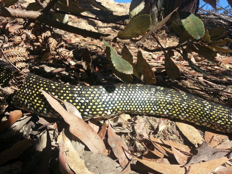
A couple of pictures of yesterdays Taffys Rock walk.

Re: Interesting side track on Cowan to Brooklyn section of G

PostPosted: Thu 18 Jul, 2013 4:26 pm
by Rob Gosford
thanks for showing the photos Lindsay

ooooooops ! :shock: i thought snakes were asleep now.....

Re: Interesting side track on Cowan to Brooklyn section of G

PostPosted: Thu 18 Jul, 2013 5:19 pm
by davidfisher71
Rob Gosford wrote:ooooooops ! :shock: i thought snakes were asleep now.....

Not on those sunny days we've been having recently ...

(Thanks for the pics, Lindsay).

Image

Re: Interesting side track on Cowan to Brooklyn section of G

PostPosted: Fri 19 Jul, 2013 1:40 am
by GPSGuided
Wow! You sure got close.