Page 1 of 2
Uloola Turrets - RNP off track near Uloola Track

Posted:
Mon 19 Aug, 2013 2:00 pmby GPSGuided
Does any one know about the approach to Uloola Turrets along Uloola Brook in the RNP? I note it's a marked spot on the topo but when we were at Uloola Falls yesterday, I didn't find a particularly obvious approach in its direction. Presumably it's all off track but do you try to access it along the brook or from a closer point along Uloola Track or Karloo Track? Anyone explored there?
Re: Uloola Turrets - RNP off track near Uloola Track

Posted:
Mon 19 Aug, 2013 2:37 pmby GPSGuided
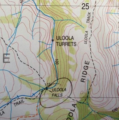
Here's a topo of the location.
Re: Uloola Turrets - RNP off track near Uloola Track

Posted:
Mon 19 Aug, 2013 3:23 pmby kanangra
Never noticed that myself? Is it an error? I can think of quite a few features up on the ridge that could be described as turrets?
K.
Re: Uloola Turrets - RNP off track near Uloola Track

Posted:
Mon 19 Aug, 2013 3:43 pmby GPSGuided
I was curious on it too. Google images associated one image with it <http://www.panoramio.com/photo/65398287>. Chapman's book 'Day Walks Sydney' seemed to suggest its a large area around that Whaleback rock. Then this topo map suggests that it's a specific rocky feature along Uloola Brook. Hence here to see if anyone knows more about it.
Re: Uloola Turrets - RNP off track near Uloola Track

Posted:
Mon 19 Aug, 2013 4:58 pmby Allchin09
GPSGuided - What map are you using? My RNP 1:35k tourist map has the Uloola Turrets labelled is a similar location to the above posted image, but only the name is given, and it is closer to the track.
I've walked the track a few times before, and I haven't ever come across them. I suspect that it is a general reference to the rock features in that area, which are of interest. If you were to visit that location, I would suggest attacking it from the track as the bush in that area isn't too hard to work your way through. The growth surrounding Uloola Brook can be hard travel through.
Below is a satellite image of the area in question. The line on the right hand side is the track, and on the left is where the Turrets are apparently located.
On a previous trip, I explored the rock features to the East of the track and found a few small caves, as well as large rock slabs with interesting slots and cracks.
Let us know if you find them!
Re: Uloola Turrets - RNP off track near Uloola Track

Posted:
Mon 19 Aug, 2013 5:48 pmby GPSGuided
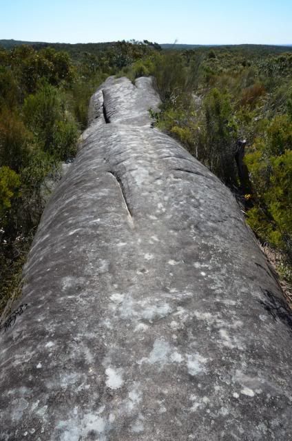
Thanks Allchin09 for the information. As mentioned earlier, we were there yesterday but I couldn't find an obvious way to access it as I was expecting it to be a spot on the brook rather than an area. The imaged topo map I posted above was out of a standard 25k topo from the Department of Lands (Port Hacking - 3rd Edition). I would have thought they would be the reference. In further reference, the 'Whaleback Rock' as seen in the photo below (part of the Uloola Track) is approx 420m south east of the 'Turrets' as marked on the 25k map. Some bushwalking notes on the net seemed to suggest the two formations are related or the same but with no certainty. Some confusion out there it seems.
Re: Uloola Turrets - RNP off track near Uloola Track

Posted:
Mon 19 Aug, 2013 6:06 pmby Allchin09
GPSGuided - Definitely some confusion!
The whaleback feature which you posted above is marked on my Tourist map, but about 800m north of where you and the satellite imagery indicates!
I would say that they are two separate features, but the location of the Turrets is still quite unclear. I guess the only way to find out is to explore it yourself!
Re: Uloola Turrets - RNP off track near Uloola Track

Posted:
Mon 19 Aug, 2013 6:12 pmby GPSGuided
Allchin09: Interesting! I wouldn't be too confident on the Tourist map on this as my reference for the Whaleback Rock (in the above photo) was marked yesterday on my GPS (S34.10553 E151.04312), spotted and distances measured in Garmin's BaseCamp. Don't try to reference the GPS Loc in the EXIF of that photo as it's secondarily entered by an automatic process using my GPS log file.
Yes, unless someone with more knowledge on this comes along, I agree this could be a point of exploration on a future trip. What surprised me was, this being a pretty heavily walked track and close to Sydney, it has yet to be properly documented. Ummm... It's a big country!
Re: Uloola Turrets - RNP off track near Uloola Track

Posted:
Mon 19 Aug, 2013 6:28 pmby DaveNoble
I was out that way recently, see -
http://www.david-noble.net/bushwalking/ ... oPool.htmlAnd look at the photos about 3/4 way down (OK - I have called it "Uloola Turrents") - which I assumed was the right place (rock formations close to the track). I am no expert on Royal National Park though.
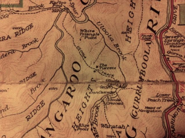
I have an old map of the park (it is not dated (circa 1960's?), but is pre-metric, and is a government map). It marks the Turrets a little to the north (and south?) of the track. The ones I visited were a little to the south of the track - but tracks can change position after bushfires etc.
- Uloola.jpg (78.22 KiB) Viewed 26342 times
and see -
http://www.nationalparks.nsw.gov.au/roy ... ck/walkingI think this implies the turrets are close to the track.
Dave
Re: Uloola Turrets - RNP off track near Uloola Track

Posted:
Mon 19 Aug, 2013 6:50 pmby Allchin09
Dave - That map of yours places the Turrets in a location quite different from that of the current day maps. I also have an old sketch map which I believe was compiled by the Boy Scouts in 1969. It shows the Turrets in the same location as your map.
I just had a look at my older version of the RNP free visitors map. It, like the 1:25k topo, places the Turrets on the Brook, just a little to the south.
My thought is that the older maps show the correct location, but somewhere along the line, someone has made a mistake and placed them elsewhere. This was then copied through on subsequent maps by the National Park and LPI.
Re: Uloola Turrets - RNP off track near Uloola Track

Posted:
Mon 19 Aug, 2013 6:55 pmby Pteropus
Re: Uloola Turrets - RNP off track near Uloola Track

Posted:
Mon 19 Aug, 2013 6:59 pmby Pteropus
My map shows the position marked on the modern maps. However, after seeing Dave's and Allchin's maps, there are two tors astride of the track, one large on the south western side, and one small on the north eastern side, in the position marked on their maps to the nw of Uloola falls. I actually have always thought they are more like turrets than what is marked on my maps.
Re: Uloola Turrets - RNP off track near Uloola Track

Posted:
Mon 19 Aug, 2013 7:21 pmby GPSGuided
Mystery deepens with the addition of the two antique maps from Dave and Alchin09! Both of them clearly put the Turrets to the West of Uloola Brook, a further 400m to the West of what's marked on current LPI map.
As for Pteropus' red circled marking, that area covers the location of Whaleback Rock based on my GPS marking. I wished I had been more observant and looked harder for a track going off to the West. Yet again, I recall that along that section, there were many open rocky platforms where the track could go off in any direction if weren't for the painted markings on the ground.
One other discrepancy. I note on the LPI topo map, the full length of track from Heathcote through Karloo Pool and onto Uloola Falls is labelled as Karloo Track, one that's confirmed on NPWS maps at trailheads. Also just noted on this NPWS map, the 'Turret' is placed a little to the East of Uloola Brook, one that's more consistent with LPI's modern map.
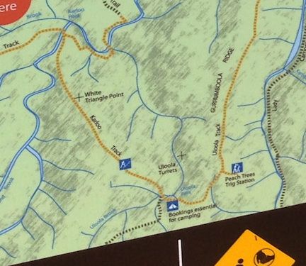
I remain amazed how successive generations of maps could move a landmark that much!
Re: Uloola Turrets - RNP off track near Uloola Track

Posted:
Mon 19 Aug, 2013 7:29 pmby Pteropus
Well, the feature that says "Peach Trees Trig Station" is what I have always thought was the Uloola Turrets that are marked on my map (published 2002) and where I took my pic down the Hacking Valley and finding the weird book and drumstick. That is the little track that I was mentioning that leads up to a little escarpment. I didn't see any trig station there though. I'd say the Turrets really are the sandstone tors marked on Dave and All's old maps. Having a look through Dave's photos they are the ones I was thinking of.
Re: Uloola Turrets - RNP off track near Uloola Track

Posted:
Mon 19 Aug, 2013 7:37 pmby Pteropus
And I just found another of my older maps, published in 1990, and it does have the turrets to the nw of Uloola Falls in the position of Dave and All's older maps.
Re: Uloola Turrets - RNP off track near Uloola Track

Posted:
Mon 19 Aug, 2013 7:38 pmby GPSGuided
Pteropus wrote:Well, the feature that says "Peach Trees Trig Station" is what I have always thought was the Uloola Turrets that are marked on my map (published 2002) and where I took my pic down the Hacking Valley and finding the weird book and drumstick. That is the little track that I was mentioning that leads up to a little escarpment. I didn't see any trig station there though. I'd say the Turrets really are the sandstone tors marked on Dave and All's old maps. Having a look through Dave's photos they are the ones I was thinking of.
But those antique maps have marked the Turrets at a location nearly half a km to the West of current day interpretation (both LPI and NPWS maps). So by my reasoning, the antique maps may mark some kind of "turret" rock formation, but it's not the Uloola Turrets in question here. Could the NPWS map be wrong also?
How can we verify this? Maybe I should give the rangers a call in the morning and learn what they know of this.
Re: Uloola Turrets - RNP off track near Uloola Track

Posted:
Mon 19 Aug, 2013 7:39 pmby kanangra
I have a few maps of RNP. None as old as Dave's. My first is the CMA map of 1976. It shows Uloola Turrets in the same location as Dave's map. So does the next one I have the 4th ed. from 1988. But the interesting thing is that the LPI map from 2002 has them on the opposite side of the creek up on the ridge south of the Whaleback rock feature.
The significant thing is that none of these tourist maps, unlike the toppo, show the turrets as being on the creek. I doubt they are down there and believe you will waste a lot of time trying to look for them down there.
K.
Re: Uloola Turrets - RNP off track near Uloola Track

Posted:
Mon 19 Aug, 2013 8:03 pmby GPSGuided
kanangra wrote:The significant thing is that none of these tourist maps, unlike the toppo, show the turrets as being on the creek. I doubt they are down there and believe you will waste a lot of time trying to look for them down there.
As commented earlier, I am surprised a feature on such a popular trail remains unverified. The map makers can't even agree on whether it's on the West or East side of Uloola Brook! Just amazing!

Re: Uloola Turrets - RNP off track near Uloola Track

Posted:
Mon 19 Aug, 2013 8:09 pmby Allchin09
Kanangra - The current tourist map given out by the RNP doesn't have the Turrets on it. It misses so many features it's not funny, check it out.
Re: Uloola Turrets - RNP off track near Uloola Track

Posted:
Mon 19 Aug, 2013 8:17 pmby GPSGuided
Not surprised that the Tourist map did not include 'Uloola Turrets'. It's off track and I doubt they want to lead hapless tourists to those locations.
Re: Uloola Turrets - RNP off track near Uloola Track

Posted:
Mon 19 Aug, 2013 8:42 pmby DaveNoble
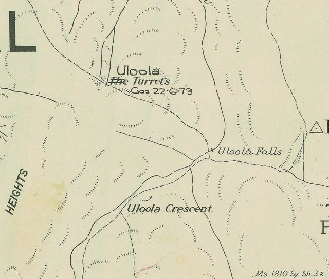
Another interesting source of information is the parish maps. A selection are online -
http://images.maps.nsw.gov.au/pixel.htm#Searching for "Heathcote" parish brings up a selection of old maps. Here is a section of one -
- Uloola2.jpg (56.11 KiB) Viewed 26247 times
It looks like the name "Uloola Turrets" was gazetted in 1973 (and before that the name was "The Turrets"). I'm not sure how old the original parish map was that has the older name. But I think we can now conclude that this location is the original and correct spot.
Dave
Re: Uloola Turrets - RNP off track near Uloola Track

Posted:
Mon 19 Aug, 2013 9:04 pmby GPSGuided
Good digging Dave! Now, who can we contact to ensure a correction is made in LPI and NPWS maps?
Re: Uloola Turrets - RNP off track near Uloola Track

Posted:
Mon 19 Aug, 2013 9:07 pmby Allchin09
Dave - I've tried to get that website working for me in the past, but I can't seem to do it. If I search by 'keyword', I get an error message telling me to 'select at least one collection to search from'...
You couldn't possibly explain how you got it to work could you?
Re: Uloola Turrets - RNP off track near Uloola Track

Posted:
Mon 19 Aug, 2013 9:18 pmby GPSGuided
Allchin09 wrote:Dave - I've tried to get that website working for me in the past, but I can't seem to do it. If I search by 'keyword', I get an error message telling me to 'select at least one collection to search from'...
I had the same problem in Safari. Switch to the latest version of Firefox (v23.0.1), logged into LPI's online store and then load Dave's link.
Re: Uloola Turrets - RNP off track near Uloola Track

Posted:
Mon 19 Aug, 2013 9:30 pmby DaveNoble
I use Safari on a Mac and also had the same problem - but did a reload - and it all started working as it should. I think the website is a bit flaky.
Dave
Re: Uloola Turrets - RNP off track near Uloola Track

Posted:
Mon 19 Aug, 2013 9:35 pmby Allchin09
Arr, didn't realise that you had to login. What a great resource that website is.
Re: Uloola Turrets - RNP off track near Uloola Track

Posted:
Mon 19 Aug, 2013 10:25 pmby GPSGuided
Not sure if login was truly needed but was the steps that worked for me. One clue that I encountered was an error message in the beginning that said something to the effect that I had to login to run the instructions.
Re: Uloola Turrets - RNP off track near Uloola Track

Posted:
Tue 20 Aug, 2013 10:36 amby Pteropus
Hi Dave and Allchin09.
Would you mind scanning or photographing those old maps and posting them? I'd love to see them.
Cheers, Andrew
Re: Uloola Turrets - RNP off track near Uloola Track

Posted:
Tue 20 Aug, 2013 5:10 pmby kjbeath
The Geographic Names board, which is where the LPI should get their information
http://www.gnb.nsw.gov.au/place_naming/ ... SXKqvqZTSX has them at Lat -34 05 54 Long 151 02 04 GDA94, which from the converter is Easting:318681.311 Northing: 6225196.949 Is that the point on the map?
Re: Uloola Turrets - RNP off track near Uloola Track

Posted:
Tue 20 Aug, 2013 7:40 pmby GPSGuided
kjbeath wrote:The Geographic Names board, which is where the LPI should get their information
http://www.gnb.nsw.gov.au/place_naming/ ... SXKqvqZTSX has them at Lat -34 05 54 Long 151 02 04 GDA94, which from the converter is Easting:318681.311 Northing: 6225196.949 Is that the point on the map?
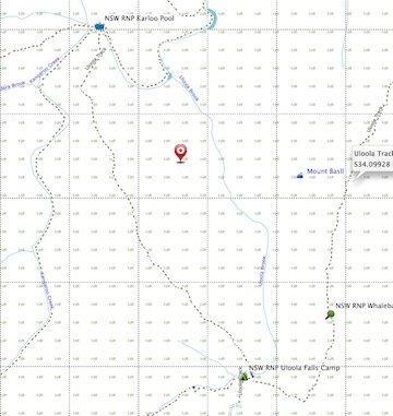
Thanks for the input. I plotted the given Loc on BaseCamp and it showed the point to be the red marker on an OSM background. At that position, it's further north to all the marked positions in the earlier maps, close to that White Triangle Point in the historical maps.
