Page 1 of 1

Mining damage within Sugarloaf Conservation Area

PostPosted: Wed 28 Aug, 2013 6:18 pm
by GPSGuided
Just read this and the damages done looked to be pretty significant. Anyone seen it up close?

http://www.smh.com.au/nsw/mine-subsiden ... 2spuc.html
Re: Mining damage within Sugarloaf Conservation Area

PostPosted: Wed 28 Aug, 2013 6:46 pm
by Greenie
Wonder if the GNW goes through this area?

Re: Mining damage within Sugarloaf Conservation Area

PostPosted: Wed 28 Aug, 2013 6:55 pm
by gayet
Its just another example of Hunter Valley mining problems. Underground, long wall, open cut. Take your pick. No mining is without significant damage. And the area will not recover. Pouring concrete into a crack simply fills the crack, in the most unsympathetic manner. Till the next slip.....

Re: Mining damage within Sugarloaf Conservation Area

PostPosted: Wed 28 Aug, 2013 8:29 pm
by forest
This is shocking and right literally in my backyard. I had no idea :evil:

The GNW sure does come down through this area, smack through the middle of it, probably not effected though as its on the main gravel trail / red off the range.

Completely unacceptable. Cannot believe some of the stupidity our environment minister has been right in the thick of.

Re: Mining damage within Sugarloaf Conservation Area

PostPosted: Wed 28 Aug, 2013 9:12 pm
by climberman
State Conservation Areas in NSW have always had a lower level of environmental protection (they used to be State Recreation Areas until Carr changed it). Mining is permissible under them, while it is not currently in a National Park.

Re: Mining damage within Sugarloaf Conservation Area

PostPosted: Wed 28 Aug, 2013 10:08 pm
by Rob Gosford
Greenie wrote:Wonder if the GNW goes through this area?


it surrre does Greenie

News Article QUOTE: "Vast sections of the reserve are cordoned off, with 24-hour security guards monitoring two access points along Archery Road."

the GNW100s - trail race(s) from Teralba (west of Newcastle), south to Yarramalong, and Patonga on the Central Coast - is coming up soon in November. The foot race follows the GNW closely and actually runs thru Archery Road Wakefield and west into the Sugarloaf Range and then down into Heaton Gap. Altho the race doesn't venture north off Archery Road and into Mt. Sugarloaf Range management trail, i hope the organisers of the GNW100s at Terrigal Trotters are aware of the earth slipages at this stage (?).

http://www.terrigaltrotters.com.au/GNW100s.htm

:shock:

Re: Mining damage within Sugarloaf Conservation Area

PostPosted: Thu 29 Aug, 2013 5:16 pm
by GPSGuided

Re: Mining damage within Sugarloaf Conservation Area

PostPosted: Thu 29 Aug, 2013 5:39 pm
by wildwalks
Stuff like this makes me sad and grumpy.
I would like to know how common events like this are - anyone know if bad stuff like this is mapped out - would be interesting to paint a picture of how often this happens and how wide spread the issue is..

Matt :)

Re: Mining damage within Sugarloaf Conservation Area

PostPosted: Thu 29 Aug, 2013 7:56 pm
by kjbeath
Mt Sugarloaf is almost 10km from the Great North Walk.

Latest news is that in trying to fix some of the cracks they have filled in several 100 metres of creek with concrete.

Re: Mining damage within Sugarloaf Conservation Area

PostPosted: Thu 29 Aug, 2013 8:05 pm
by GPSGuided
Did some reading last night and apparently caulking is a standard technique in mining to fill in faults in the geology, but obviously never designed to correct problems of this magnitude. Sounds to be a pretty desperate attempt to rectify the problem.

Re: Mining damage within Sugarloaf Conservation Area

PostPosted: Thu 29 Aug, 2013 8:59 pm
by kjbeath
GPSGuided wrote:Did some reading last night and apparently caulking is a standard technique in mining to fill in faults in the geology, but obviously never designed to correct problems of this magnitude. Sounds to be a pretty desperate attempt to rectify the problem.


It looks like they tried to fill a crack and didn't notice that it was flowing out the other end and down the creek. I heard it was 8 truckloads so someone wasn't doing a lot of thinking. I assume the reason for doing it is to stop people falling in the holes.

Re: Mining damage within Sugarloaf Conservation Area

PostPosted: Thu 29 Aug, 2013 9:08 pm
by GPSGuided
I understand that grouting is used to stabilise fault lines to prevent and control subsidence.

Re: Mining damage within Sugarloaf Conservation Area

PostPosted: Fri 30 Aug, 2013 7:27 am
by forest
kjbeath wrote:Mt Sugarloaf is almost 10km from the Great North Walk.

Latest news is that in trying to fix some of the cracks they have filled in several 100 metres of creek with concrete.


Mt sugerloaf might be 10kms from the area involved but the GNW goes smack through the effected area near archery rd.

Re: Mining damage within Sugarloaf Conservation Area

PostPosted: Fri 30 Aug, 2013 8:39 am
by Rob Gosford
Rob Gosford wrote:Altho the race doesn't venture north off Archery Road and into Mt. Sugarloaf Range management trail, i hope the organisers of the GNW100s at Terrigal Trotters are aware of the earth slipages at this stage (?).

http://www.terrigaltrotters.com.au/GNW100s.htm

:shock:


the organisers of the GNW100s have replied to an email i sent (mentioning to them of the situation up there), and they are already aware of the situation. The organisers will be checking the GNW again closer to the event in November to make sure they will be able to get through, AND safely 8)

Re: Mining damage within Sugarloaf Conservation Area

PostPosted: Fri 30 Aug, 2013 11:22 am
by wildwalks
Interesting map by Herald here
http://www.theherald.com.au/story/17410 ... nd/?cs=305
Shows where the underground mine is.

Looks like a small gap with the freeway. But shows how much of the park is been undermined.

Matt :)

Re: Mining damage within Sugarloaf Conservation Area

PostPosted: Fri 30 Aug, 2013 12:35 pm
by Rob Gosford
good work with the map Matt :D
From here, it looks like Wakefield Forest Rd (the GNW in between Archery and Sugarloaf Range firetrail) goes right over the top of Longwall 41. I would be treading c a r e f u l l y along Wakefield Forest Rd ..........as you travel west, the steep bit just before Sugarloaf Range firetrail :o

Re: Mining damage within Sugarloaf Conservation Area

PostPosted: Fri 30 Aug, 2013 12:49 pm
by wildwalks
Thanks Rob

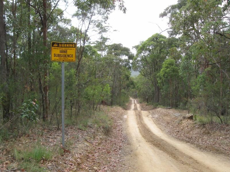
There are warning signs along this section of track
http://www.wildwalks.com/i.html?image_id=357697

Before this you could see some cracking on the surface - but minor compared to this mis-adventure.

A good reason for Ultra-light hiking :)

Matt :)

Re: Mining damage within Sugarloaf Conservation Area

PostPosted: Fri 30 Aug, 2013 1:33 pm
by Rob Gosford
thanks for the photo link Matt. you have a better camera than me.

and here is a photo i took last November.......

Image

i'm just thinking how sad it is about the local fauna up there, many losing their homes, burrows. From Archery Rd thru to Heaton Gap along the GNW the beauty of the place is outstanding :D

yes, Ultra-light hiking for sure lol