Page 1 of 1
Great North Walk: The Benowie Track

Posted:
Sun 28 Sep, 2014 3:57 pmby Mariske
Hi there,
I've set myself to walking the Great North Walk. I hope to be able to do about 10-12k every Sunday, and getting to Newcastle in about half a year. A major task...
I'm now at the Benowie Track part (from Thornleigh to Berowra Waters Trackhead. Today, I got to Galston Gorge Trackhead. For my next trip, I need some advise, and I hope some of you can give it to me:
1. Since I have no car or anything, I have to completely rely on public transportation (which, unfortunatly, there is almost none on this part of the trail...). Next Sunday, I'd like to start hiking at Galston Gorge or Crosslandds Trackhead, or somewhere in between. Can somebody give me advise on how easiest to come to either of those places by public transport and walking?
2. I read that the bridge at Calna Creek is broken. I think it still is broken; is that right? If so, is there an alternative way to walk? Or another way to cross Calna Creek?
I hope somebody can help me with these questions. I really REALLY like hiking the GNW and can't wait for next Sunday so I can return to the trail!
Re: Great North Walk: The Benowie Track

Posted:
Tue 30 Sep, 2014 9:57 amby Lindsay
Hi Mariske,
This section of the GNW is well known to me and I often walk Hornsby to Berowra as a day walk, using public transport to and from the track heads. Forget starting at Galston Gorge or Crosslands, as there is no public transport, apart from taxis. My usual routine is to walk from Hornsby (Quarry Road track head near the railway station), down to Fishponds, along to Steele Bridge, then to Galston gorge, on to Crosslands and to Calna creek. (There is a crossing a little way upstream from the bridge where the creek can be forded). Just across the bridge there is a choice of routes, Up the side track to Mt Kuring-gai or continue along the GNW past Sams Creek and up to Berowra. Both Mt K. and Berowra track heads are easy walking distance from the railway stations. It is slightly longer to take the Mt K turnoff than to continue on to Berowra.
The total distance is about 22ks, and I usually take about 8 hours to complete the walk, including stops. Although this may require a bit of backtracking over sections you have already done, and a longer day than usual for you, it's the best way to complete this section utilising public transport.
Re: Great North Walk: The Benowie Track

Posted:
Tue 30 Sep, 2014 10:57 amby Bluegum Mic
Ditto the above post. The only way possible is to bus it to hornsby heights and come down from the watertank off montview and its not that clear from memory. Id either recover the part you've done and start at hornsby/quarry rd or you'll miss a bit and start at Mt Kuring gai (which puts you on the GNW just past the broken bridge on calna creek).
Re: Great North Walk: The Benowie Track

Posted:
Tue 30 Sep, 2014 3:55 pmby Rob Gosford
Mariske wrote:Hi there,
I've set myself to walking the Great North Walk. I hope to be able to do about 10-12k every Sunday, and getting to Newcastle in about half a year. A major task...
"A major task..."
and a wonderful achievement too, but from the entry into the Watagans at Cedar Brush Trackhead (north of Yarramalong), to the EXIT at Heaton Lookout (about 65klms) , IMHO you should take someone with you.....

Re: Great North Walk: The Benowie Track

Posted:
Thu 02 Oct, 2014 1:32 pmby Mariske
Thanks all for your advise. Unfortunately, walking all the way from Hornsby to Mt K. (22k) is too far for me - I can't do that much on one day, my condition isn't that great yet... Also, to be honest, I didn't find the part from Horsnby to Galston Gorge too nice...
I've been looking into taking the McKay Trail down to the GNW, but it seems like that trail just kind of ends somewhere in the bushes. No idea if I can come from the end of that trail to the GNW... So I might walk down from Horsnby station to Galston Gorge via Galston Road and continue from there (about 5k), or skip a bit and start at Mt. K station.
In any case, there will be more difficulties with reaching the trail by public transport at other points, I reckon... So I might have to skip some more pieces, unfortunately.
Rob: You said I might have to take somebody else with me on that part - I will, thanks for the advise! Any more tips and tricks?
Thanks heaps everybody!
Re: Great North Walk: The Benowie Track

Posted:
Mon 06 Oct, 2014 9:21 amby skibug
Hi Mariske,
Nice personal challenge.
The track from the end of Montview. past the water tank, links to the GNW - it's a fire trail for, say, 600m, then narrows to a short, steepish but perfectly obvious walking track. You can see it on Google Earth. The busses run every hour or so to the end of Montview from Hornsby station. You could walk down Galston Road to the gorge, but there's no footpath and would be a bit unnerving - maybe 45 minutes from the bus stop. The track that bypasses the broken Calna Creek bridge departs on the right about 20 minutes after Crosslands - there is then a footpad that descends steeply to the left - it has been "taped", gets to the high tide mark, follows that upstream maybe 50 metres, then crosses the edge of a grass wetland that is quite boggy in spots. When you get to mangroves, turn right again, go another 50 metres and look for a gap in the mangroves to the stream itself. Check tides - I've crossed here at low tide without needing to remove shoes, but at high tide it's chest deep.
The non-repair of Calna Creek Bridge is a shame on the local authorities.
Skibug
Re: Great North Walk: The Benowie Track

Posted:
Sun 21 Dec, 2014 10:37 pmby RobN
Hi Mariske
Have you completed the GNW yet? I am in the process doing section at a time too. I've done about a 1/3: all the south section up to Hornsby, Mt Ku-ring-gah to Brooklyn and a few up north. If you are still going please let me know. It will be good to ask someone, is this the right way? I don't have a car the moment but am driving it down February 2015.
Cheers
Rob
Re: Great North Walk: The Benowie Track

Posted:
Fri 02 Nov, 2018 9:18 pmby Aelkiki
Hello,
Does anyone know if the McKay trail connects to the Benowie track?
Re: Great North Walk: The Benowie Track

Posted:
Sat 03 Nov, 2018 7:39 pmby rcaffin
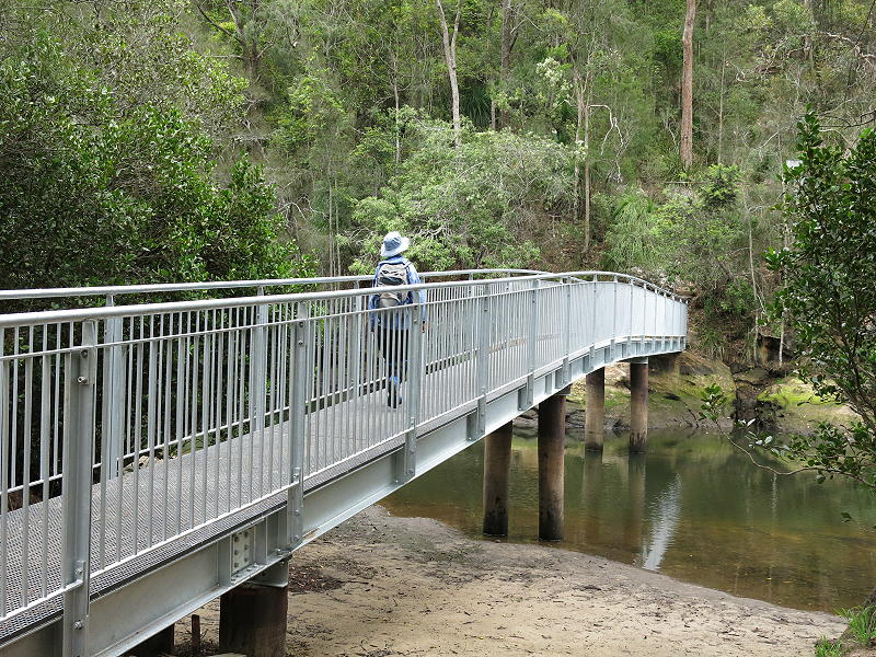
Calna Ck got a new bridge towards the end of 2015. It takes time for budgets to get through the system ... or so they say.

- 6739.jpg (182.93 KiB) Viewed 18038 times
Cheers
Roger
Re: Great North Walk: The Benowie Track

Posted:
Sat 03 Nov, 2018 8:40 pmby johnw
Aelkiki wrote:Does anyone know if the McKay trail connects to the Benowie track?
Last year I walked that GNW section going from Berowra through to Hornsby, including crossing Roger's new bridge (again)

.
I still like the old log bridge, it had a lot of character.
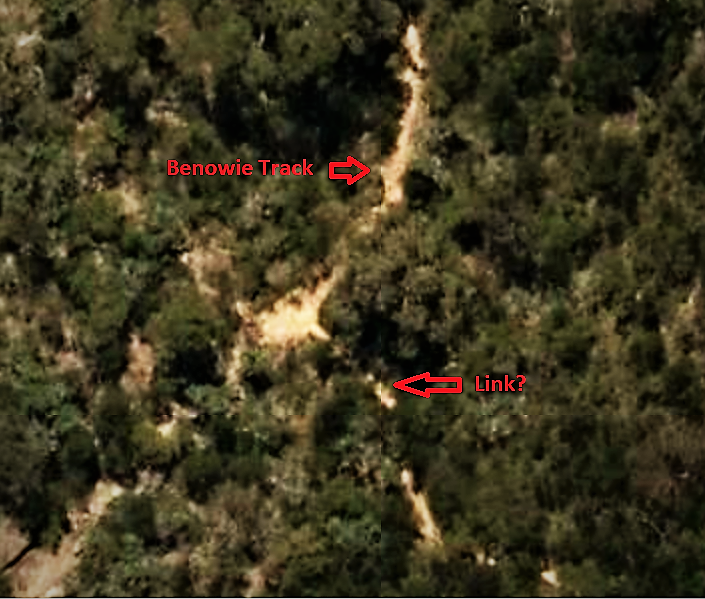
Bottom line, I can't remember if I saw anything that would help. However a quick look at SIX Maps topo aerial imagery view suggests there may be a linking track.
There is only a short distance between the two tracks. Can't be guaranteed but I'd be fairly confident it's there.

- Benowie track McKay trail connection.png (689.63 KiB) Viewed 18030 times
Re: Great North Walk: The Benowie Track

Posted:
Sun 04 Nov, 2018 6:53 amby Warin
OSM shows a connection from Benowie to Makays .. see
https://hiking.waymarkedtrails.org/#route?id=1388126
Re: Great North Walk: Somersby Store to Yarramalong

Posted:
Sun 09 Dec, 2018 1:23 pmby Bush_walker
Hi, I am doing this walk in sections as day and overnight as well.
Now I reach up to somersby store, Now I am planing to do from Somersby Store to Yarramalong Store.
I usually like to park my cat where I end the walk so there will be no issue of timing to get public transport.
I am sill searching the way to park my car at Yarramalong Store and get back to Somersby store to start my walk.
Please advice is there any way to get public transport like Bus or the only option I have is Taxi or Ubber.
Re: Great North Walk: Somersby Store to Yarramalong

Posted:
Sun 09 Dec, 2018 2:38 pmby Warin
Bush_walker wrote:I usually like to park my cat
Most of them walk away .. you must have yours well trained.. or dead.

Bush_walker wrote: get public transport.
I am sill searching the way to park my car at Yarramalong Store and get back to Somersby store to start my walk.
Please advice is there any way to get public transport like Bus or the only option I have is Taxi or Ubber.
No buses at Yarramalong. Possibly a 'school bus'??? Ring 'busways' and find out?
Alternative - park the cat/car at Central Mangrove and take the bus to Somersby .. walk to Yarramalong and then walk back to Central Mangrove.
Re: Great North Walk: The Benowie Track

Posted:
Mon 10 Dec, 2018 12:01 amby Bush_walker
Hi Warin, good one

, sorry for typo as I am really not good in typing.
Thanks for response, what if I keep walking further for another section and go for two nights.
So plan is I park my Car "not cat

" and start walk from Somersby store, can i get the Bus and get back to somersby store where I finish my walk, is there any bus route from any other section or no way at all.
Re: Great North Walk: The Benowie Track

Posted:
Sat 27 Jun, 2020 6:40 pmby DGR
It is possible to walk from McKay Rd, Hornsby Heights along the McKay Trail and the steep, rocky track connecting to the Benowie Track of the Great North Walk. We'd like to thank whoever put the pink ribbons on the trees guiding us from the end of McKay Trail down to the Benowie Track - we would have struggled to find the way without the pink ribbons. It took about 30 mins from McKay Rd at the Water Tower to the Benowie Track.