Can anyone help me with the name of the creek that starts at Rawsons Pass?
It then heads north between Muellers Pass/Peak and Etheridge Ridge before joining the Snowy River. I can't see it named on any of the maps I have. Maybe it doesn't have a name but thought it worth asking.
Name of creek north of Mt Kosciuszko
Forum rules
NSW & ACT specific bushwalking discussion. Please avoid publishing details of access to sensitive areas with no tracks.
NSW & ACT specific bushwalking discussion. Please avoid publishing details of access to sensitive areas with no tracks.
6 posts
• Page 1 of 1
Name of creek north of Mt Kosciuszko
![]() by crollsurf » Wed 05 Jul, 2023 11:29 am
by crollsurf » Wed 05 Jul, 2023 11:29 am
-

crollsurf - Lagarostrobos franklinii

- Posts: 2317
- Joined: Tue 07 Mar, 2017 10:07 am
- Location: Sydney
- Region: New South Wales
- Gender: Male
Re: Name of creek north of Mt Kosciuszko
![]() by eggs » Wed 05 Jul, 2023 2:06 pm
by eggs » Wed 05 Jul, 2023 2:06 pm
There is a photo on Google Maps which labels it Rawson Creek.
-
eggs - Lagarostrobos franklinii
- Posts: 10835
- Joined: Fri 23 May, 2008 2:58 pm
- Location: Para Vista, South Australia
- Region: South Australia
Re: Name of creek north of Mt Kosciuszko
![]() by johnw » Wed 05 Jul, 2023 3:36 pm
by johnw » Wed 05 Jul, 2023 3:36 pm
Many years ago I remember crossing it once, down in the upper Snowy valley, via the shortcut pad between Seamans Hut and Muellers Pass.
I have a small collection of books, maps etc for the region, possibly some older, rarer ones. When I get a chance I'll have a look for any references re the name.
Nothing on NSW Geo Names Board, only Rawson Pass, Alice Rawson Peak (official) and Mt Alice Rawson (variant).
But I did find this online, which may help form a view that it's named informally:
https://mulubinba.com.au/wp-content/uploads/2017/03/Summer-Walking-Guide-Rev-A-.pdf
On page 4 (end section of the Kunama Ruins track notes) it states:
And one of our own, NNW, makes a clear reference to it here:
https://www.bushwalk.com/forum/viewtopic.php?f=36&t=18178#p244121
This person looks to be making a similar reference:
https://www.kev570.com/snowy31.jpg
I have a small collection of books, maps etc for the region, possibly some older, rarer ones. When I get a chance I'll have a look for any references re the name.
Nothing on NSW Geo Names Board, only Rawson Pass, Alice Rawson Peak (official) and Mt Alice Rawson (variant).
But I did find this online, which may help form a view that it's named informally:
https://mulubinba.com.au/wp-content/uploads/2017/03/Summer-Walking-Guide-Rev-A-.pdf
On page 4 (end section of the Kunama Ruins track notes) it states:
Or for the fit and adventurous, an interesting and strenuous circuit can be done by climbing the steep slope to the S, across the saddle between Mts Northcote and Clarke, and dropping down in to the gully that joins Rawsons Creek.
And one of our own, NNW, makes a clear reference to it here:
https://www.bushwalk.com/forum/viewtopic.php?f=36&t=18178#p244121
This person looks to be making a similar reference:
https://www.kev570.com/snowy31.jpg
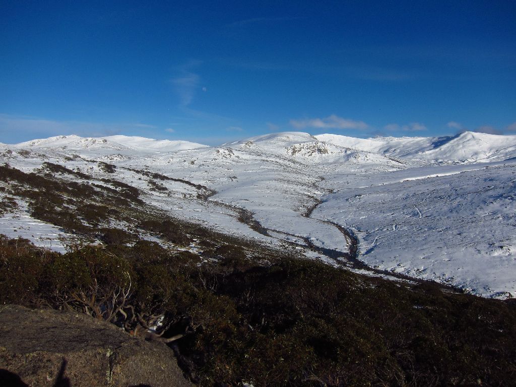
The Snowy River running down from Mt Kosciuszko (left) and Rawson Creek running down from Mt Clarke (centre).
John W
In Nature's keeping they are safe, but through the agency of man destruction is making rapid progress - John Muir c1912
In Nature's keeping they are safe, but through the agency of man destruction is making rapid progress - John Muir c1912
-
johnw - Lagarostrobos franklinii
- Posts: 9684
- Joined: Wed 23 Jan, 2008 11:59 am
- Location: Macarthur Region - SW Sydney
- Region: New South Wales
- Gender: Male
Re: Name of creek north of Mt Kosciuszko
![]() by crollsurf » Wed 05 Jul, 2023 6:32 pm
by crollsurf » Wed 05 Jul, 2023 6:32 pm
Thanks both, so it appears to have no official name, but is commonly known as Rawsons Creek.
-
crollsurf - Lagarostrobos franklinii
- Posts: 2317
- Joined: Tue 07 Mar, 2017 10:07 am
- Location: Sydney
- Region: New South Wales
- Gender: Male
Re: Name of creek north of Mt Kosciuszko
![]() by snowygreybeard » Tue 11 Jul, 2023 6:39 pm
by snowygreybeard » Tue 11 Jul, 2023 6:39 pm
The creek in the middle of that photo is Club Lake Creek. The OP was talking about the one upper left - which went past Rawsons Hut.
- snowygreybeard
- Atherosperma moschatum

- Posts: 72
- Joined: Fri 09 Nov, 2018 10:02 am
- Region: New South Wales
- Gender: Male
Re: Name of creek north of Mt Kosciuszko
![]() by johnw » Sat 15 Jul, 2023 11:06 am
by johnw » Sat 15 Jul, 2023 11:06 am
snowygreybeard wrote:The creek in the middle of that photo is Club Lake Creek. The OP was talking about the one upper left - which went past Rawsons Hut.
I should have looked at that caption more closely. Yes, the dominant creek in the centre is definitely Club Lake Creek coming down from below Carruthers.
Rawson/s Creek is more obscure in the photo.
John W
In Nature's keeping they are safe, but through the agency of man destruction is making rapid progress - John Muir c1912
In Nature's keeping they are safe, but through the agency of man destruction is making rapid progress - John Muir c1912
-
johnw - Lagarostrobos franklinii
- Posts: 9684
- Joined: Wed 23 Jan, 2008 11:59 am
- Location: Macarthur Region - SW Sydney
- Region: New South Wales
- Gender: Male
6 posts
• Page 1 of 1
Return to New South Wales & ACT
Who is online
Users browsing this forum: No registered users and 9 guests