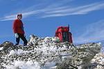
Just wanted to put a trip summary up of my recent k2k hike- as I haven’t seen any recent post on the current conditions-
Infamous K2K- Kanangra to Katoomba
3 days/45km
Date: 18/3/25 - 19/3/25
Difficulty Level- Hard (experienced hikers only)
See my youtube video of Day 1
( https://youtu.be/S2cmJZuJIuE?si=Npoqe3GRb3AmC-wq) ( will upload the rest over the next week. ) (@tigers.stripes “infamous k2k- Kanangra to Katoomba “
Trip Summary-
Overall- Going into this after reading many many negative reviews advising against doing this- we went into it with a can do attitude and fully prepared. We had a really fun adventurous time on this hike. it was completely different to every other hike I’ve ever done and it was such a good experience. I would highly recommend doing this if you’re experienced/ have the gear and time.
Go into it expecting to go very slow, be continually pushing through brush, trees and constantly looking for a trail and following purely a gps heading. It was a proper expedition and adventure. Feel free to comment, or message me with any questions you’ve got!
Lost/Missing- Black Diamond Alpine Carbon Cork ($300) hiking Poles with my name engraved on them- somewhere between mount strong leg and cox ( can send my gps bread crumb trail)
Day 1 ( 12km) (2km\hr): Walls to Dex Creek. We found the second half of this section to be very overgrown and potentially the worst part of the hike. The trail was there but parts were very very faint and needed the gps to follow.
Day 2 (16km) (2km/hr): Dex Creek to Mobbs Swamp. This section was consistently overgrown however wasn’t as bad as we thought it was based on the reviews. Going from mt strong leg down to cox wasn’t too bad at all. And the trail is a mostly able to keep on the trail. Definitely a few sections where we lost it, but were able to find it again. We left at 7 and arrived at Cox at 1pm and had a swim near where the trail goes up the hill. The trail going up mount yellow dog after cox was great, very clear, but steep. After mount yellow dog it went back to being overgrown all the way to Mobbs swamp. However the foot pad was clear and could easily be followed.
Day 3 (17km)(3-3.5km/hr): Mobbs Swamp to Narrow Neck gate - We left at 5am under torch light- trail was slightly overgrown for the first few kms but easy to follow. And then opened up to being great and back to a normal hike.
Transport: We left a car at Narrowneck Gate and had a great friend drive us 2 hours to Kanangra Walls (start)
Water: Carried 6L of water day 1 and 2 based on the reviews we’d read about how over grown the track was. And 3 L on the final day. Would do this same amount again as it gave us some redundancy if needed and if Dex was dry. There was flowing water at all 3 campsites for us. Mobbs swamp also had a drop toilet.
Highly Recommended Gear:
-EPIRB
-Snake bite kit ( saw 2 snakes and a lot of time you couldn’t see your feet in parts)
-clear safety glasses ( bush bashing in the early morning/ low light when you can’t use your sunglasses, many near misses with branches in the eyes )
-long plants ( decent material- ended up with tears, the whole hike you are being wacked on the shins)
-long shirt ( decent material- ended up shredding my hiking shirt on both arms, continually being wacked with branches)
-GPS with Trail .GPX file loaded, with backup battery’s ( a lot of the sections you are in 4-5m thick bush unable to get any visual reference on mountains or reference points. A lot of time we were purely looking at the gps and following the track as we bushed back through)
Weather: we had 26 during the days and 12 over night mostly, and then foggy day on day 3 which made for a nice change and cool weather to climb out. Would be tough to do this on 28+ degree days as in the thick of the scrub it can be still and hot.
https://youtu.be/S2cmJZuJIuE?si=2deNyC_Oyoy9XfVy
Infamous Kanangra to Katoomba Hike (K2K)- Blue Mountains
Forum rules
NSW & ACT specific bushwalking discussion. Please avoid publishing details of access to sensitive areas with no tracks.
NSW & ACT specific bushwalking discussion. Please avoid publishing details of access to sensitive areas with no tracks.
13 posts
• Page 1 of 1
Infamous Kanangra to Katoomba Hike (K2K)- Blue Mountains
![]() by Tigers_Stripes » Mon 24 Feb, 2025 9:35 pm
by Tigers_Stripes » Mon 24 Feb, 2025 9:35 pm
- Tigers_Stripes
- Nothofagus cunninghamii

- Posts: 5
- Joined: Mon 24 Feb, 2025 9:27 pm
- Region: New South Wales
Re: Infamous Kanangra to Katoomba Hike (K2K)- Blue Mountains
![]() by rcaffin » Fri 28 Feb, 2025 7:21 pm
by rcaffin » Fri 28 Feb, 2025 7:21 pm
Mobbs Swamp with a drop loo?
Decadence!
Can't say I agree that a GPS is needed: generations of walkers have done it without, and with much poorer tracks (where there were any).
Once you get to Kanagra you can return via the Kanagra Ck, which can be very fast travelling in a drought.
Cheers
Decadence!
Can't say I agree that a GPS is needed: generations of walkers have done it without, and with much poorer tracks (where there were any).
Once you get to Kanagra you can return via the Kanagra Ck, which can be very fast travelling in a drought.
Cheers
Last edited by rcaffin on Sun 02 Mar, 2025 2:16 pm, edited 1 time in total.
-
rcaffin - Athrotaxis selaginoides

- Posts: 1312
- Joined: Thu 17 Jul, 2008 3:46 pm
Re: Infamous Kanangra to Katoomba Hike (K2K)- Blue Mountains
![]() by tom_brennan » Sun 02 Mar, 2025 2:08 pm
by tom_brennan » Sun 02 Mar, 2025 2:08 pm
Oops! 
- Attachments
-
- 2025-03-02 15_07_23-YouTube — Mozilla Firefox.png (6.92 KiB) Viewed 4044 times
Bushwalking NSW - http://bushwalkingnsw.com
-
tom_brennan - Athrotaxis selaginoides
- Posts: 1430
- Joined: Wed 29 Sep, 2010 9:21 am
- Location: Sydney
- Region: New South Wales
- Gender: Male
Re: Infamous Kanangra to Katoomba Hike (K2K)- Blue Mountains
![]() by rcaffin » Sun 02 Mar, 2025 2:23 pm
by rcaffin » Sun 02 Mar, 2025 2:23 pm
I wonder what you wrote to get YT all stirred up?
-
rcaffin - Athrotaxis selaginoides
- Posts: 1312
- Joined: Thu 17 Jul, 2008 3:46 pm
Re: Infamous Kanangra to Katoomba Hike (K2K)- Blue Mountains
![]() by Warin » Sun 02 Mar, 2025 3:05 pm
by Warin » Sun 02 Mar, 2025 3:05 pm
rcaffin wrote:Can't say I agree that a GPS is needed: generations of walkers have done it without, and with much poorer tracks (where there were any).
Note the lack of maps in the 'recommendations'.
'Old school' is paper maps and compass. Some maps were hand drawn. I still make notes on my paper maps.
These days a 'smart phone' with off line maps (and builtin GPS) are 'more poplar'. Many will find flat batteries are an issue.
-

Warin - Athrotaxis selaginoides
- Posts: 1468
- Joined: Sat 11 Nov, 2017 8:02 am
- Region: New South Wales
Re: Infamous Kanangra to Katoomba Hike (K2K)- Blue Mountains
![]() by Allchin09 » Sun 02 Mar, 2025 3:52 pm
by Allchin09 » Sun 02 Mar, 2025 3:52 pm
tom_brennan wrote:Oops!
Maybe some skinny dipping in the Cox?
Tackling the unknown and the awesome one adventure at a time!
Try www.bushwalkingmaps.com
Try www.bushwalkingmaps.com
- Allchin09
- Phyllocladus aspleniifolius

- Posts: 715
- Joined: Fri 27 Apr, 2012 3:24 pm
- ASSOCIATED ORGANISATIONS: Sydney Bush Walkers
- Region: New South Wales
- Gender: Male
Re: Infamous Kanangra to Katoomba Hike (K2K)- Blue Mountains
![]() by Walk_fat boy_walk » Sun 02 Mar, 2025 4:15 pm
by Walk_fat boy_walk » Sun 02 Mar, 2025 4:15 pm
Either way I'm guessing cox were involved. I'm still trying to figure out what is "infamous" about the k2k?Allchin09 wrote:tom_brennan wrote:Oops!
Maybe some skinny dipping in the Cox?
Sent from my Pixel 9 Pro using Tapatalk
- Walk_fat boy_walk
- Lagarostrobos franklinii

- Posts: 2354
- Joined: Sat 21 Nov, 2009 6:59 am
- Gender: Male
Re: Infamous Kanangra to Katoomba Hike (K2K)- Blue Mountains
![]() by rcaffin » Sun 02 Mar, 2025 4:50 pm
by rcaffin » Sun 02 Mar, 2025 4:50 pm
It is actually COXS river
Pity YouTube
Cheers
Roger
Pity YouTube
Cheers
Roger
-
rcaffin - Athrotaxis selaginoides
- Posts: 1312
- Joined: Thu 17 Jul, 2008 3:46 pm
Re: Infamous Kanangra to Katoomba Hike (K2K)- Blue Mountains
![]() by puredingo » Mon 03 Mar, 2025 9:53 am
by puredingo » Mon 03 Mar, 2025 9:53 am
Walk_fat boy_walk wrote:Either way I'm guessing cox were involved. I'm still trying to figure out what is "infamous" about the k2k?Allchin09 wrote:tom_brennan wrote:Oops!
Maybe some skinny dipping in the Cox?
Sent from my Pixel 9 Pro using Tapatalk
I’m assuming all the recent tales of Woe and the trip reports condemning it a tangled mess of energy sapping, lifestyle questioning weeds?
But as soon as I get back from a month surfing in Indo I’m in there! You keen?
- puredingo
- Athrotaxis selaginoides
- Posts: 1326
- Joined: Mon 13 Feb, 2012 6:54 am
- Region: New South Wales
Re: Infamous Kanangra to Katoomba Hike (K2K)- Blue Mountains
![]() by Tigers_Stripes » Tue 04 Mar, 2025 10:06 am
by Tigers_Stripes » Tue 04 Mar, 2025 10:06 am
Tigers_Stripes wrote:Just wanted to put a trip summary up of my recent k2k hike- as I haven’t seen any recent post on the current conditions-
Date: 18/3/25 - 19/3/25
See my youtube video of Day 1
( https://youtu.be/S2cmJZuJIuE?si=Npoqe3GRb3AmC-wq) ( will upload the rest over the next week. ) (@tigers.stripes “infamous k2k- Kanangra to Katoomba “
https://youtu.be/S2cmJZuJIuE?si=2deNyC_Oyoy9XfVy
Update- The actual date of the trip : 18/2/25 - 19/2/25
Updated Youtube link (indeed skinny dipping was involved):
https://youtu.be/qc96l6Z8uug?si=ho2UUbbXTjtzf-3O
- Tigers_Stripes
- Nothofagus cunninghamii
- Posts: 5
- Joined: Mon 24 Feb, 2025 9:27 pm
- Region: New South Wales
Re: Infamous Kanangra to Katoomba Hike (K2K)- Blue Mountains
![]() by Tigers_Stripes » Tue 04 Mar, 2025 10:41 am
by Tigers_Stripes » Tue 04 Mar, 2025 10:41 am
Warin wrote:rcaffin wrote:Can't say I agree that a GPS is needed: generations of walkers have done it without, and with much poorer tracks (where there were any).
Note the lack of maps in the 'recommendations'.
'Old school' is paper maps and compass. Some maps were hand drawn. I still make notes on my paper maps.
These days a 'smart phone' with off line maps (and builtin GPS) are 'more poplar'. Many will find flat batteries are an issue.
Thanks for all the replies!
Totally! I also hate reading reviews that say "need" or "must haves"- I personally don't like being told what i can and can't do- and hence i said i personally recommend it but i don't say you need a GPS. Like all things- with the advancement of technology the way we approach situations change. Once upon a time people didn't wear hiking boots, didn't use tents, didn't use stoves or didn't even use papers maps or compass'. Could you still hike without these advancements- sure you can!
Gear selection is a personal thing based on experience and also apetite for adventure. In this instance- based on the fact that in the recent years all of the reviews of this trail have been negative and advised against doing it- the recommendation i made i felt would set more people up for a more enjoyable k2k trip and hopefully encourage more people to give it a go while having controls in place to reduce some of negatives people have experienced on this trip in the past.
With all things with changes in technology- having redundancy in your systems is important- ie emergency matches for fire instead of stove, purification tabs if you can't find fresh water, EPIRB if you don't have reception, needle and thread for repairs, patches for air mattress, and finally spare battery, paper maps, powerbanks or additional gps' to give redundancy for your primary GPS. On this trip between my hiking partner and myself we had a total of 5 GPS units with the GPX files loaded (2 x Inreachs, 2 x phones, 1 x garmin watch) additionally we had 2 x powerbanks and the ability to cross charge devices. This would mean we could navigate for up to 30 Days on any one of the devices. I'm about to head over to the USA and hike the PCT trail (4280km over 5.5months) and it will be rare to see someone utilising a paper map.
I believe the K2K is infamous due to all of the recent negative reviews of the trail, additionally I heard on a recent podcast of a rescue on the K2k that stated the start of the k2k once had the most activations of a EPIRB in NSW. Give it a go and post up your thoughts! PS. Let me know if you find my Black Diamond Alpine cork hiking poles
- Tigers_Stripes
- Nothofagus cunninghamii
- Posts: 5
- Joined: Mon 24 Feb, 2025 9:27 pm
- Region: New South Wales
Re: Infamous Kanangra to Katoomba Hike (K2K)- Blue Mountains
![]() by rcaffin » Tue 04 Mar, 2025 1:05 pm
by rcaffin » Tue 04 Mar, 2025 1:05 pm
All the negative reviews
What we may be seeing here is an upsurge in the number of novices trying to do a route well beyond their knowledge or abilities. That may sound elitist, or it may be realistic. Once upon a time, the only people doing anything off the beaten track were people who had the required experience, but today the informal publicity about such walks is far more widespread, attracting far more attention. Perhaps far too much. One notes the pink warning at the top:
Please avoid publishing details of access to sensitive areas with no tracks.
a total of 5 GPS units with the GPX files loaded (2 x Inreachs, 2 x phones, 1 x garmin watch) additionally we had 2 x powerbanks
Blimey! Think of all that extra weight.
This would mean we could navigate for up to 30 Days on any one of the devices.
One of our long overseas trips in the European mountains a few years ago was for 3 months (90 days) - and all we had were maps and compasses. It IS possible to live off a map. But then, the early Australian explorers had NO maps.
Off to America eh? Watch out you don't get picked up by ICE - like a German tourist recently.
Cheers
Roger
-
rcaffin - Athrotaxis selaginoides
- Posts: 1312
- Joined: Thu 17 Jul, 2008 3:46 pm
Re: Infamous Kanangra to Katoomba Hike (K2K)- Blue Mountains
![]() by Hoojar » Tue 04 Mar, 2025 1:19 pm
by Hoojar » Tue 04 Mar, 2025 1:19 pm
Tigers_Stripes wrote:EPIRB if you don't have reception
I really hope that hikers are carrying PLBs and not EPIRBs.
https://www.gme.net.au/au/news/epirb-vs-plb/
- Hoojar
- Nothofagus gunnii

- Posts: 41
- Joined: Wed 20 Jun, 2018 4:24 pm
- Region: New South Wales
13 posts
• Page 1 of 1
Return to New South Wales & ACT
Who is online
Users browsing this forum: No registered users and 62 guests