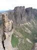
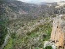
From O’Briens Crossing the easy to follow track made for good pace for this part of the walk. There were plenty of good views of the river with many quite spots to camp along the river on this section of the walk. The final descent to the river at Razorback North Track was quite steep but easily negotiated with care.
- P1050020.jpg (128.77 KiB) Viewed 28992 times
We set up our camp for the first night on the small flat spot right beside the river. As this a State Park fires are allowed, and so the girls cooked themselves some marshmallows until it came time for bed.
- P1060021.jpg (138.27 KiB) Viewed 28992 times
The next stage of the walk is river walking. It turned out to take longer for us than expected and so we decided early that we wouldn’t make it all the way to Mackenzies Flat by midday Friday and so took our time making our way along the river eventually deciding to camp on a nice shaded spot from the afternoon sun near the start of the Ah Kow Track.
- P1060046.jpg (146 KiB) Viewed 28992 times
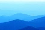
The walk along the river was amazing with numerous quite waterholes and excellent camping spots. There are myriads of native plants to enjoy and bird life is prevalent – especially the Sulfur-crested Cockatoos – for those so inclined. The recent rains have brought the river to life with many tadpoles and frogs frequenting the ponds along the way. Just lazing on the rocks overlooking the reflective pools was enough to convince us that we need to take the time to complete the rest of the walk in the not too distant future. For the history buffs, there are numerous examples of old mining sites to be found along river, usually where there are large bends. The all-consuming desire to find the precious metal was obviously extremely strong for the miners who worked these sites!
While this section of the walk is hard, as there is no track and the river is crisscrossed numerous times to bypass the cliffs and scrub, there are a number of access tracks on both sides of the river all the way to Mackenzies Flat, especially to as far as the Ah Kow Ruin and Mine. There was Telstra coverage every time I turned on my phone, so it was easy to call my wife to arrange for a different pick up spot.
- P1070061.jpg (171.4 KiB) Viewed 28992 times
We used the Lerderderg and Werribee Gorges map (3rd Ed.) published by Meridian Maps. If you PM me I can give the grid references of the campsites we thought best.