Hannels Spur Loop, Easter 2019, Parts 1 & 2
Forum rules
Posting large/multiple images in this forum is OK. Please start topic titles with the name of the location or track.
For topics focussed on photos rather than the trip, please consider posting in the 'Gallery' forum instead.
This forum is for posting information about trips you have done, not for requesting information about a track or area.
45 posts
• Page 2 of 2 • 1, 2
Re: Hannels Spur Loop, Easter 2019, Parts 1 & 2
![]() by Stew63 » Fri 03 May, 2019 6:48 pm
by Stew63 » Fri 03 May, 2019 6:48 pm
Oh great trip report too Mr C!
- Stew63
- Athrotaxis cupressoides

- Posts: 390
- Joined: Sat 03 Mar, 2012 2:53 am
- Location: Eltham, Victoria
- Region: Other Country
- Gender: Male
Re: Hannels Spur Loop, Easter 2019, Parts 1 & 2
![]() by puredingo » Wed 08 May, 2019 3:42 pm
by puredingo » Wed 08 May, 2019 3:42 pm
Roger, where do get the water proof paper from?
I’m nervous about the topo map shortage of the future and my supply is very tatty indeed.
I’m nervous about the topo map shortage of the future and my supply is very tatty indeed.
- puredingo
- Athrotaxis selaginoides

- Posts: 1325
- Joined: Mon 13 Feb, 2012 6:54 am
- Region: New South Wales
Re: Hannels Spur Loop, Easter 2019, Parts 1 & 2
![]() by rcaffin » Wed 08 May, 2019 4:18 pm
by rcaffin » Wed 08 May, 2019 4:18 pm
Just do an internet search on 'waterproof paper site:au' and you will tons of hits. A few dollars for a pack.
You will even find the stuff on eBay and Amazon. A common laser printer will do nicely.
A common international brand is 'Rite-in-Rain' - I have used that, but many other brands.
An A3 laser printer or an A3 photocopier is deluxe - I have reams of A3 copies ...
You can also get waterproof sleeves on eBay: also a good idea just for mechanical protection.
Cheers
Roger
-
rcaffin - Athrotaxis selaginoides
- Posts: 1294
- Joined: Thu 17 Jul, 2008 3:46 pm
Re: Hannels Spur Loop, Easter 2019, Parts 1 & 2
![]() by puredingo » Wed 08 May, 2019 9:01 pm
by puredingo » Wed 08 May, 2019 9:01 pm
Thanks mate,
This information shall be transferred to the missus because basically....I’m useless.
This information shall be transferred to the missus because basically....I’m useless.
- puredingo
- Athrotaxis selaginoides
- Posts: 1325
- Joined: Mon 13 Feb, 2012 6:54 am
- Region: New South Wales
Re: Hannels Spur Loop, Easter 2019, Parts 1 & 2
![]() by rcaffin » Wed 08 May, 2019 9:12 pm
by rcaffin » Wed 08 May, 2019 9:12 pm
You got her the info, didn't you?
Cheers
Roger
Cheers
Roger
-
rcaffin - Athrotaxis selaginoides
- Posts: 1294
- Joined: Thu 17 Jul, 2008 3:46 pm
Re: Hannels Spur Loop, Easter 2019, Parts 1 & 2
![]() by Zapruda » Thu 09 May, 2019 11:06 am
by Zapruda » Thu 09 May, 2019 11:06 am
I grabbed a set of these Sutmaps off Bruce at Wilderness Sports in Jindabyne. They are waterproof and tear proof. I really like them. They have just the right amount of detail and all three weigh less than one NSW topo. Because of their size they are very manageable in the wind.
There are only 3 maps available for KNP - Jagungal, Schlink Pass, Kosciuszko. These 3 maps cover the areas north of the Charcoal Range all the way to just south of Tabletop. I would prefer a set for the northern end of the park but oh well...
There are only 3 maps available for KNP - Jagungal, Schlink Pass, Kosciuszko. These 3 maps cover the areas north of the Charcoal Range all the way to just south of Tabletop. I would prefer a set for the northern end of the park but oh well...
- Attachments
-
-
-
Zapruda - Athrotaxis selaginoides
- Posts: 1682
- Joined: Thu 07 Apr, 2016 10:46 am
- Region: Australian Capital Territory
- Gender: Male
Re: Hannels Spur Loop, Easter 2019, Parts 1 & 2
![]() by Summitview » Mon 14 Oct, 2019 1:45 pm
by Summitview » Mon 14 Oct, 2019 1:45 pm
Hi Roger
I went down Hannels Spur in 1978 and went up it two years ago - before the track was cleared.
I am looking at going up again in December. My partner is very fit but not that keen on pushing through scrub. From your post and an article in Wild, I gather the route has been cut up to Byatts Camp, but that a section right at the base of the spur might be a bit scrubby. Does that fit your memory of it?
Also interested in your advice as to how best to get from the top of the spur to the Mt Kosciuszko track (noting your comments about boulders). We traversed rather slowly into Wilkinsons Valley from a bit above the treeline. In regards to Byatts Camp, we found it difficult to identify where this was, as different maps seemed to locate it in different places.
cheers
Jonathan
- Summitview
- Atherosperma moschatum

- Posts: 62
- Joined: Sun 18 Dec, 2011 2:40 pm
- Region: Australian Capital Territory
- Gender: Male
Re: Hannels Spur Loop, Easter 2019, Parts 1 & 2
![]() by rcaffin » Mon 14 Oct, 2019 2:20 pm
by rcaffin » Mon 14 Oct, 2019 2:20 pm
Actually, they started cutting from the top down. So now it has all been cut.
When we did it the first time we went up from the bottom. We followed some sort of track to a wooden NPWS sign at the bottom (somewhere) and then went up VERY steeply for some distance. There was a taped track, but we were using tree roots as holds. Then we followed the crest of the spur up to the saddles at around 1000 m and camped in one large saddle. Going up to Moiras Flat was scrubby: we followed the spur. We did pass through Moiras Flat (sign post to water), but I am not sure there was a real lot of track from there to the top either. I forget how we got from the signboard over the Abbotts range into the Wilkinson valley.
This last time, going downwards, we made the huge mistake of following the Townsend track and trying to go OVER Abbott. That was very rough. We should have followed the Wilkinson valley downstream to a signboard and then gone up to the saddle to the left (west?) of all the Abbotts bit. From there a track goes down to Byatts camp (it's a basin with water) and then across to the old wood signboard on a cut track. From the signboard down it is steep, with lots of leaves. I sat down (abruptly) a few times.
The cut track goes through the first small saddle around 1000 m (where we found room for ONE tent), but then it dives down to cross a gully - which did not show any water when we were there. But we did not search. I am fairly sure that we had camped at the top of this gully on the first trip in a generous flat area. Beyond that the cut track eventually starts to sidle down the right side of the spur (a bit slippery); I am sure we had followed the crest of the spur going upwards. I reckon that was easier. Why did they sidle? Dunno. But eventually the cut track becomes a very easy grassy 4WD track down to the Geehi Flats, a metal signboard, and a 4WD track to Dr Forbes.
I am not sure where we went up the first time relative to this metal signboard, but the difference in angles was huge!
So the whole track is cut, and it may be nicer going upwards rather than downwards, despite the grunt. You won't slip as much. Big climb though. When you get to the top signboard, turn right and follow the cut track.
Cheers
Roger
-
rcaffin - Athrotaxis selaginoides
- Posts: 1294
- Joined: Thu 17 Jul, 2008 3:46 pm
Re: Hannels Spur Loop, Easter 2019, Parts 1 & 2
![]() by Summitview » Fri 18 Oct, 2019 11:52 am
by Summitview » Fri 18 Oct, 2019 11:52 am
Many thanks, Roger. I suspect last time when we were going up we left the Hannels Spur track before we go to the old signboard, which I take it is on an extension of the Hannels Spur track.
If you don't mind checking, is the high saddle you mention above that marked as between Abbott Peak and spotheight 2159 (about GR 121677?), or is it about GR 117674 (not sure if my map is the old or new Grid datum).
Thanks
Jonathan
If you don't mind checking, is the high saddle you mention above that marked as between Abbott Peak and spotheight 2159 (about GR 121677?), or is it about GR 117674 (not sure if my map is the old or new Grid datum).
Thanks
Jonathan
- Summitview
- Atherosperma moschatum
- Posts: 62
- Joined: Sun 18 Dec, 2011 2:40 pm
- Region: Australian Capital Territory
- Gender: Male
Re: Hannels Spur Loop, Easter 2019, Parts 1 & 2
![]() by rcaffin » Fri 18 Oct, 2019 12:50 pm
by rcaffin » Fri 18 Oct, 2019 12:50 pm
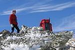
Byatts Camp is wrongly labeled on the old topo map anyhow. It is the basin about 1 km WSW of point 2159 around 1840 m alt.
The saddle(s) you want on Abbott Ridge are around 2020 m, just a bit over 1 km SSW of pt 2159. You will note the broken contour lines above 2000 m to the N of these saddles: BIG granite boulders which present some difficulties in passing over them.
The old wood signboard is at the top end of the Hannels Spur track, ON the track.
The track goes NW down from here, and to the S from here. Find it. Headed down, you can see the problems with dead trees.
They will keep falling over the track for the next 10+ years.
Cheers
Roger
The saddle(s) you want on Abbott Ridge are around 2020 m, just a bit over 1 km SSW of pt 2159. You will note the broken contour lines above 2000 m to the N of these saddles: BIG granite boulders which present some difficulties in passing over them.
The old wood signboard is at the top end of the Hannels Spur track, ON the track.
- 8728.jpg (185.04 KiB) Viewed 30069 times
The track goes NW down from here, and to the S from here. Find it. Headed down, you can see the problems with dead trees.
- 8729.jpg (200.16 KiB) Viewed 30069 times
They will keep falling over the track for the next 10+ years.
Cheers
Roger
-
rcaffin - Athrotaxis selaginoides
- Posts: 1294
- Joined: Thu 17 Jul, 2008 3:46 pm
Re: Hannels Spur Loop, Easter 2019, Parts 1 & 2
![]() by paidal_chalne_vala » Fri 18 Oct, 2019 1:17 pm
by paidal_chalne_vala » Fri 18 Oct, 2019 1:17 pm
We walked up Hannel's Spur in April 2019. The track is already becoming a jungle gym with fallen trees. It is S T E E P ! . In a year or two it will become much tougher to pass through. I would suggest all walkers should get up there this green season but don't do it if the weather is hot.. The same would apply to the route up/down Champion Spur in VIC. on the Razorback . It has been re cut with a bulldozer up to nearly 2 kms short of the summit ridge.
- paidal_chalne_vala
- Lagarostrobos franklinii

- Posts: 2719
- Joined: Sun 22 Jan, 2012 10:30 pm
- ASSOCIATED ORGANISATIONS: VNPA.BTAC.Friends of Baw Baw.Mt.Bogong Club.
- Region: Victoria
- Gender: Male
Re: Hannels Spur Loop, Easter 2019, Parts 1 & 2
![]() by Summitview » Fri 18 Oct, 2019 2:48 pm
by Summitview » Fri 18 Oct, 2019 2:48 pm
Thanks Roger. Very helpful.
- Summitview
- Atherosperma moschatum
- Posts: 62
- Joined: Sun 18 Dec, 2011 2:40 pm
- Region: Australian Capital Territory
- Gender: Male
Re: Hannels Spur Loop, Easter 2019, Parts 1 & 2
![]() by andrewa » Fri 18 Oct, 2019 3:48 pm
by andrewa » Fri 18 Oct, 2019 3:48 pm
We went up and down Anzac Day “Weekend” - everything was pretty obvious from the bottom, but we found the hardest bit was finding the rather random small cairns marking the route above the tree line. It was no harder in cloud, on the way up, than it was in clear sunshine on the way down. The few times we decided to proceed without eyeballing the next cairn turned out to be slow and unpleasant in the prickly alpine bushes.
Below the tree line, it was very well marked.
A
Below the tree line, it was very well marked.
A
- andrewa
- Athrotaxis selaginoides
- Posts: 1432
- Joined: Sat 05 Mar, 2011 5:55 pm
- ASSOCIATED ORGANISATIONS: None
- Region: Victoria
- Gender: Male
Re: Hannels Spur Loop, Easter 2019, Parts 1 & 2
![]() by rcaffin » Fri 18 Oct, 2019 7:34 pm
by rcaffin » Fri 18 Oct, 2019 7:34 pm
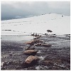
Hum - the regrowth must be fast. We found the cut track between Byatts and the wood signpost fairly clear - although we could see the cairns ahead. They are not large. This photo is from near the signpost looking back towards Byatts:
The two blue lines point to the next two cairns: 2 or 3 small stones on the left, and a stick pointing upwards on the right. Small discrete little markers.
The red line pointing into the valley behind the spur marks the approx location of Byatts.
I suspect that back in the cattle days, all this would have been burnt by the cattlemen every year for grass. There's good grass under the scrub.
Cheers
Roger
- 8727.jpg (210.84 KiB) Viewed 30012 times
The two blue lines point to the next two cairns: 2 or 3 small stones on the left, and a stick pointing upwards on the right. Small discrete little markers.
The red line pointing into the valley behind the spur marks the approx location of Byatts.
I suspect that back in the cattle days, all this would have been burnt by the cattlemen every year for grass. There's good grass under the scrub.
Cheers
Roger
-
rcaffin - Athrotaxis selaginoides
- Posts: 1294
- Joined: Thu 17 Jul, 2008 3:46 pm
Re: Hannels Spur Loop, Easter 2019, Parts 1 & 2
![]() by andrewa » Sat 19 Oct, 2019 7:59 pm
by andrewa » Sat 19 Oct, 2019 7:59 pm
As shown in Roger’s post, the cairns can be subtle, and we had the additional benefit of fairly dense cloud to try to find the little buggers in!
A
A
- andrewa
- Athrotaxis selaginoides
- Posts: 1432
- Joined: Sat 05 Mar, 2011 5:55 pm
- ASSOCIATED ORGANISATIONS: None
- Region: Victoria
- Gender: Male
45 posts
• Page 2 of 2 • 1, 2
Return to NSW & ACT Trip Reports & Track Notes
Who is online
Users browsing this forum: No registered users and 2 guests