michael_p wrote:I am pretty sure the trail that johnw mentioned is the Buxton Plateau walk. Have no idea where it starts but it runs along the top of the hills on your left as you head out on the trail.
Hi Michael, yes that's the one. It actually starts at the end of Buxton Rd at Buxton (not Bargo as I suggested originally). Walked it in 2005 according to my photos. Nearly 17km so was a bit of a grind, although you may be able to cycle that trail. The sketch map in the Sloss book does show a negotiable route down to Little River near the end.
michael_p wrote:I know that SHB have done walks on the plateaus to the right hand side (as you head out on the trail) of Blue Gum creek (Mt Rice/Couridjah Mountain area) but where they start is a mystery as well. I've been told by someone who was on those walks that it was mostly on fire trails and the views were good.
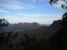
Looks like there is a trail finishing at "Blue Gum Mt", I'm guessing it starts somewhere west of Thirlmere. Unsure about the peak names or those of other features. R Sloss often uses his own unofficial names that don't exist on relevant topo maps.
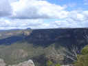
michael_p wrote:Personally I think the walks starting at the end of Wattle Ridge Road in Hilltop are better bushwalks. Chasm Lookout, Rocky Waterholes Creek, Starlights Trail and my personal favourite Ahearn Lookout are all worth the effort. There is another track that runs off Ahearn down into Rocky Waterholes Creek but I haven't tried it yet. Also Mermaids Pool and the Tahmoor Canyon walks are good as well. As johnw mentioned the books by Robert Sloss are handy (I've also heard a rumour that these books may be updated soon).
I've done several of those walks and a few others. Favourite is possibly Starlights, including overnighting down there. A good circuit is to return via the old Troys Creek track although it makes a fairly long fire trail bash to finish. Think I've seen an updated edition of one of his books, might have been mid or lower Blue Mountains, not sure.