You do learn something about distances in this game when you start opening up maps... Thelist 1:25000 and google maps both going flat out here.
The rough location was easy enough because of the amount of fagus on the hillsides. The biggest clue was revealed by eggs, surely referring to Lake Fenton. Certainly the shape of the southern side matches.
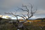
Lining up the angle of the shore and taking into account the wide angle obviously used to fit that much bush into the photo in the foreground, you must be at Seagers Lookout.
GAME: Where am I?
Forum rules
Only administrators may post new topics to this forum. Registered users can post replies.
Only administrators may post new topics to this forum. Registered users can post replies.
Re: GAME: Where Am I? (Continued)
![]() by tasadam » Tue 15 Dec, 2009 5:18 pm
by tasadam » Tue 15 Dec, 2009 5:18 pm
-
tasadam - Magnus administratio

- Posts: 5900
- Joined: Tue 10 Apr, 2007 6:58 pm
- Location: Near Devonport, Tasmania
- ASSOCIATED ORGANISATIONS: TasmaniART, Smitten Merino, Macpac
- Region: Tasmania
- Gender: Male
Re: GAME: Where Am I? (Continued)
![]() by whynotwalk » Tue 15 Dec, 2009 5:38 pm
by whynotwalk » Tue 15 Dec, 2009 5:38 pm
Yep - Seagers LO it is. Well deduced Adam
Solvitur ambulando (Walking solves it) - attributed to St Augustine, 4th century AD.
-

whynotwalk - Athrotaxis selaginoides

- Posts: 1335
- Joined: Tue 24 Jun, 2008 12:57 pm
- Location: Cascades
- Region: Tasmania
- Gender: Male
Re: GAME: Where Am I? (Continued)
![]() by tasadam » Tue 15 Dec, 2009 5:48 pm
by tasadam » Tue 15 Dec, 2009 5:48 pm
I was helped a lot by eggs on that one, I hadn't scanned far enough away from Lake Dobson to seriously consider that lake (dam) as a candidate until I got his clue.
OK let's see what I can find.
OK let's see what I can find.
- Mt Hyperion photographed from Acropolis.
-
tasadam - Magnus administratio
- Posts: 5900
- Joined: Tue 10 Apr, 2007 6:58 pm
- Location: Near Devonport, Tasmania
- ASSOCIATED ORGANISATIONS: TasmaniART, Smitten Merino, Macpac
- Region: Tasmania
- Gender: Male
Re: GAME: Where Am I? (Continued)
![]() by tasadam » Tue 15 Dec, 2009 6:44 pm
by tasadam » Tue 15 Dec, 2009 6:44 pm
Where is everyone? This one should be a bit easier than my last one.
-
tasadam - Magnus administratio
- Posts: 5900
- Joined: Tue 10 Apr, 2007 6:58 pm
- Location: Near Devonport, Tasmania
- ASSOCIATED ORGANISATIONS: TasmaniART, Smitten Merino, Macpac
- Region: Tasmania
- Gender: Male
Re: GAME: Where Am I? (Continued)
![]() by eggs » Tue 15 Dec, 2009 6:58 pm
by eggs » Tue 15 Dec, 2009 6:58 pm
Shooting from the hip - I am thinking Hyperion from the walk up the Ducaine range from the Labrynth?
-
eggs - Lagarostrobos franklinii

- Posts: 10860
- Joined: Fri 23 May, 2008 2:58 pm
- Location: Para Vista, South Australia
- Region: South Australia
Re: GAME: Where Am I? (Continued)
![]() by tasadam » Tue 15 Dec, 2009 7:02 pm
by tasadam » Tue 15 Dec, 2009 7:02 pm
Close. Right mountain that I am looking at, right view (sort of), but my location is somewhat out. More zoom than that. I'm on a mountain, not far from its summit. Isn't it a great view from up there tho, where you say. I was going thru photos looking for potential images for the game and all the photos from that area are so obvious.
-
tasadam - Magnus administratio
- Posts: 5900
- Joined: Tue 10 Apr, 2007 6:58 pm
- Location: Near Devonport, Tasmania
- ASSOCIATED ORGANISATIONS: TasmaniART, Smitten Merino, Macpac
- Region: Tasmania
- Gender: Male
Re: GAME: Where Am I? (Continued)
![]() by eggs » Tue 15 Dec, 2009 7:37 pm
by eggs » Tue 15 Dec, 2009 7:37 pm
The only low peak nearby I can think of is Eros?
But the angle looks totally wrong - and perhaps you are higher than you seem. Is this from Massif?
But the angle looks totally wrong - and perhaps you are higher than you seem. Is this from Massif?
-
eggs - Lagarostrobos franklinii
- Posts: 10860
- Joined: Fri 23 May, 2008 2:58 pm
- Location: Para Vista, South Australia
- Region: South Australia
Re: GAME: Where Am I? (Continued)
![]() by tasadam » Tue 15 Dec, 2009 7:42 pm
by tasadam » Tue 15 Dec, 2009 7:42 pm
No and no and perhaps a bit more zoom.
-
tasadam - Magnus administratio
- Posts: 5900
- Joined: Tue 10 Apr, 2007 6:58 pm
- Location: Near Devonport, Tasmania
- ASSOCIATED ORGANISATIONS: TasmaniART, Smitten Merino, Macpac
- Region: Tasmania
- Gender: Male
Re: GAME: Where Am I? (Continued)
![]() by eggs » Tue 15 Dec, 2009 8:08 pm
by eggs » Tue 15 Dec, 2009 8:08 pm
Looks like its just you and me.
A bit of shame I have got so many wrong.
The foreground says not Geryon, and the angle says not Walled Mtn, but it could be the Acropolis?
A bit of shame I have got so many wrong.
The foreground says not Geryon, and the angle says not Walled Mtn, but it could be the Acropolis?
-
eggs - Lagarostrobos franklinii
- Posts: 10860
- Joined: Fri 23 May, 2008 2:58 pm
- Location: Para Vista, South Australia
- Region: South Australia
Re: GAME: Where Am I? (Continued)
![]() by ILUVSWTAS » Tue 15 Dec, 2009 8:16 pm
by ILUVSWTAS » Tue 15 Dec, 2009 8:16 pm
You know after the recent talk of Hyperion, I actually thought this was the famous peak!! Could it be from Falling Mtn??
A few people I know have said this is one of the most difficult peaks to climb
A few people I know have said this is one of the most difficult peaks to climb
Nothing to see here.
-

ILUVSWTAS - Lagarostrobos franklinii
- Posts: 11027
- Joined: Sun 28 Dec, 2008 9:53 am
- Region: Tasmania
- Gender: Male
Re: GAME: Where Am I? (Continued)
![]() by tasadam » Tue 15 Dec, 2009 8:19 pm
by tasadam » Tue 15 Dec, 2009 8:19 pm
eggs wrote:it could be the Acropolis?
Sheesh, took your time
Here is a different photo, but the same view.
Your go eggs.
-
tasadam - Magnus administratio
- Posts: 5900
- Joined: Tue 10 Apr, 2007 6:58 pm
- Location: Near Devonport, Tasmania
- ASSOCIATED ORGANISATIONS: TasmaniART, Smitten Merino, Macpac
- Region: Tasmania
- Gender: Male
Re: GAME: Where Am I? (Continued)
![]() by eggs » Tue 15 Dec, 2009 8:29 pm
by eggs » Tue 15 Dec, 2009 8:29 pm
Well that was tricky.
Next time I won't shoot from the hip
This one is for Taure-rana... [now I know why some call her elf-lady for ease.]
The view is of the White Monolith Range. [PS - not Moniloths ILUVSWTAS ]
]
Next time I won't shoot from the hip
This one is for Taure-rana... [now I know why some call her elf-lady for ease.]
The view is of the White Monolith Range. [PS - not Moniloths ILUVSWTAS
- zoom shot of the White Monolith Range (not moniloth!) with Mt Machonocie on the right from the summit of Hesperus in the Western Arthurs
Last edited by eggs on Tue 15 Dec, 2009 8:33 pm, edited 1 time in total.
-
eggs - Lagarostrobos franklinii
- Posts: 10860
- Joined: Fri 23 May, 2008 2:58 pm
- Location: Para Vista, South Australia
- Region: South Australia
Re: GAME: Where Am I? (Continued)
![]() by ILUVSWTAS » Tue 15 Dec, 2009 8:32 pm
by ILUVSWTAS » Tue 15 Dec, 2009 8:32 pm
Haha yeh easier to spell isnt it.... Hey leave my spelling alone.... we've established by now im a bad speller... cant we just leave it at that and let some of my mistakes ride....
Well has anyone been up Hyperion?? Is it truly difficult????
Eggs you HAVE to be on the Frankland range somewhere... Maybe thats remote peak on the right??
I'll start with the Cupola??
Well has anyone been up Hyperion?? Is it truly difficult????
Eggs you HAVE to be on the Frankland range somewhere... Maybe thats remote peak on the right??
I'll start with the Cupola??
Last edited by ILUVSWTAS on Tue 15 Dec, 2009 8:34 pm, edited 1 time in total.
Nothing to see here.
-
ILUVSWTAS - Lagarostrobos franklinii
- Posts: 11027
- Joined: Sun 28 Dec, 2008 9:53 am
- Region: Tasmania
- Gender: Male
-
eggs - Lagarostrobos franklinii
- Posts: 10860
- Joined: Fri 23 May, 2008 2:58 pm
- Location: Para Vista, South Australia
- Region: South Australia
Re: GAME: Where Am I? (Continued)
![]() by ILUVSWTAS » Tue 15 Dec, 2009 8:35 pm
by ILUVSWTAS » Tue 15 Dec, 2009 8:35 pm
Hmmm Ok the Arthurs then... Hersperus??
Nothing to see here.
-
ILUVSWTAS - Lagarostrobos franklinii
- Posts: 11027
- Joined: Sun 28 Dec, 2008 9:53 am
- Region: Tasmania
- Gender: Male
Re: GAME: Where Am I? (Continued)
![]() by eggs » Tue 15 Dec, 2009 8:39 pm
by eggs » Tue 15 Dec, 2009 8:39 pm
Yes - a zoom shot of the White Monolith Range (not moniloth!) with Mt Machonocie on the right from the summit of Hesperus in the Western Arthurs
-
eggs - Lagarostrobos franklinii
- Posts: 10860
- Joined: Fri 23 May, 2008 2:58 pm
- Location: Para Vista, South Australia
- Region: South Australia
Re: GAME: Where Am I? (Continued)
![]() by ILUVSWTAS » Tue 15 Dec, 2009 8:42 pm
by ILUVSWTAS » Tue 15 Dec, 2009 8:42 pm
Lith Loth... whats the difference.....
- Attachments
-
Nothing to see here.
-
ILUVSWTAS - Lagarostrobos franklinii
- Posts: 11027
- Joined: Sun 28 Dec, 2008 9:53 am
- Region: Tasmania
- Gender: Male
Re: GAME: Where Am I? (Continued)
![]() by eggs » Tue 15 Dec, 2009 8:49 pm
by eggs » Tue 15 Dec, 2009 8:49 pm
Its that search tool thingy.
When Taure-rana said she had no idea where moniloths where in Tasmania - I thought she might need a picture.
But when I searched for the post - I couldn't find it. It was then that the penny dropped that she may have been having a go at the spelling.
When Taure-rana said she had no idea where moniloths where in Tasmania - I thought she might need a picture.
But when I searched for the post - I couldn't find it. It was then that the penny dropped that she may have been having a go at the spelling.
-
eggs - Lagarostrobos franklinii
- Posts: 10860
- Joined: Fri 23 May, 2008 2:58 pm
- Location: Para Vista, South Australia
- Region: South Australia
Re: GAME: Where Am I? (Continued)
![]() by ILUVSWTAS » Tue 15 Dec, 2009 9:06 pm
by ILUVSWTAS » Tue 15 Dec, 2009 9:06 pm
Everyone else has a go at my spelling, she may as well join in... 
Nothing to see here.
-
ILUVSWTAS - Lagarostrobos franklinii
- Posts: 11027
- Joined: Sun 28 Dec, 2008 9:53 am
- Region: Tasmania
- Gender: Male
Re: GAME: Where Am I? (Continued)
![]() by tasadam » Tue 15 Dec, 2009 9:09 pm
by tasadam » Tue 15 Dec, 2009 9:09 pm
Lakes that look like that... Dead trees... How about Rogoona? Looks more like the ridge to the north than the actual summit.
-
tasadam - Magnus administratio
- Posts: 5900
- Joined: Tue 10 Apr, 2007 6:58 pm
- Location: Near Devonport, Tasmania
- ASSOCIATED ORGANISATIONS: TasmaniART, Smitten Merino, Macpac
- Region: Tasmania
- Gender: Male
Re: GAME: Where Am I? (Continued)
![]() by tasadam » Tue 15 Dec, 2009 9:11 pm
by tasadam » Tue 15 Dec, 2009 9:11 pm
Then again, I suppose you're going to tell us it's in the southwest again...
-
tasadam - Magnus administratio
- Posts: 5900
- Joined: Tue 10 Apr, 2007 6:58 pm
- Location: Near Devonport, Tasmania
- ASSOCIATED ORGANISATIONS: TasmaniART, Smitten Merino, Macpac
- Region: Tasmania
- Gender: Male
Re: GAME: Where Am I? (Continued)
![]() by ILUVSWTAS » Tue 15 Dec, 2009 9:16 pm
by ILUVSWTAS » Tue 15 Dec, 2009 9:16 pm
Not Rigoonu (yes now im misspelling on purpose)
And no clues!! I do however OCCASIONALLY post pics that arent in the southwest.....
And no clues!! I do however OCCASIONALLY post pics that arent in the southwest.....
Nothing to see here.
-
ILUVSWTAS - Lagarostrobos franklinii
- Posts: 11027
- Joined: Sun 28 Dec, 2008 9:53 am
- Region: Tasmania
- Gender: Male
Re: GAME: Where Am I? (Continued)
![]() by tasadam » Tue 15 Dec, 2009 9:26 pm
by tasadam » Tue 15 Dec, 2009 9:26 pm
There are also a lot of lakes from the Walls area, could it be somewhere like Jerusalem? Warmer?
-
tasadam - Magnus administratio
- Posts: 5900
- Joined: Tue 10 Apr, 2007 6:58 pm
- Location: Near Devonport, Tasmania
- ASSOCIATED ORGANISATIONS: TasmaniART, Smitten Merino, Macpac
- Region: Tasmania
- Gender: Male
Re: GAME: Where Am I? (Continued)
![]() by ILUVSWTAS » Tue 15 Dec, 2009 9:33 pm
by ILUVSWTAS » Tue 15 Dec, 2009 9:33 pm
Maybe slightly but maybe not, probably equal distance away from this place.
Nothing to see here.
-
ILUVSWTAS - Lagarostrobos franklinii
- Posts: 11027
- Joined: Sun 28 Dec, 2008 9:53 am
- Region: Tasmania
- Gender: Male
Re: GAME: Where Am I? (Continued)
![]() by tasadam » Tue 15 Dec, 2009 10:59 pm
by tasadam » Tue 15 Dec, 2009 10:59 pm
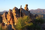
Wentworth Hills?
(Cheating a bit)
(Cheating a bit)
-
tasadam - Magnus administratio
- Posts: 5900
- Joined: Tue 10 Apr, 2007 6:58 pm
- Location: Near Devonport, Tasmania
- ASSOCIATED ORGANISATIONS: TasmaniART, Smitten Merino, Macpac
- Region: Tasmania
- Gender: Male
Re: GAME: Where Am I? (Continued)
![]() by ILUVSWTAS » Wed 16 Dec, 2009 7:08 am
by ILUVSWTAS » Wed 16 Dec, 2009 7:08 am
Again with the cheating?? hehehe im just going to have to stop putting pictures of my walks up if this continues Adam!!
Yup, Looking east from the summit of the lovely Wentworth Hills!!
Yup, Looking east from the summit of the lovely Wentworth Hills!!
Nothing to see here.
-
ILUVSWTAS - Lagarostrobos franklinii
- Posts: 11027
- Joined: Sun 28 Dec, 2008 9:53 am
- Region: Tasmania
- Gender: Male
-
tasadam - Magnus administratio
- Posts: 5900
- Joined: Tue 10 Apr, 2007 6:58 pm
- Location: Near Devonport, Tasmania
- ASSOCIATED ORGANISATIONS: TasmaniART, Smitten Merino, Macpac
- Region: Tasmania
- Gender: Male
Re: GAME: Where Am I? (Continued)
![]() by ILUVSWTAS » Wed 16 Dec, 2009 7:59 am
by ILUVSWTAS » Wed 16 Dec, 2009 7:59 am
Your liking this place at the moment arent you Adam....
Ok as I havent been there it's all just guesswork. From Geyron campsite?
Ok as I havent been there it's all just guesswork. From Geyron campsite?
Nothing to see here.
-
ILUVSWTAS - Lagarostrobos franklinii
- Posts: 11027
- Joined: Sun 28 Dec, 2008 9:53 am
- Region: Tasmania
- Gender: Male
Re: GAME: Where Am I? (Continued)
![]() by tasadam » Wed 16 Dec, 2009 8:25 am
by tasadam » Wed 16 Dec, 2009 8:25 am
No. Hey, look at that. I cannot just say "No."
I get an error that says
Well, that gets me my 5 characters.
So, again, No.
Compare with last image of mine, see if that helps. Swing round a bit.
I get an error that says
Your message contains 3 characters. The minimum number of characters you need to enter is 5.
Well, that gets me my 5 characters.
So, again, No.
Compare with last image of mine, see if that helps. Swing round a bit.
-
tasadam - Magnus administratio
- Posts: 5900
- Joined: Tue 10 Apr, 2007 6:58 pm
- Location: Near Devonport, Tasmania
- ASSOCIATED ORGANISATIONS: TasmaniART, Smitten Merino, Macpac
- Region: Tasmania
- Gender: Male
Re: GAME: Where Am I? (Continued)
![]() by stu » Wed 16 Dec, 2009 8:33 am
by stu » Wed 16 Dec, 2009 8:33 am
I'd say in the Labyrinth somewhere, probably somewhere around Lake Elysia?
-

stu - Lagarostrobos franklinii
- Posts: 2168
- Joined: Fri 02 May, 2008 8:31 am
- Region: Tasmania
Return to Games and Competitions
Who is online
Users browsing this forum: No registered users and 51 guests