Once the final corner is turned the track evens out a bit and becomes a little fainter again, but it's still easy open ground, wandering through low scrubby trees. The are snatches of view in all directions except straight up to Margaret, but they're all between trees - both dead and green - so getting a decent photo of it is almost impossible. A little further on a knoll is reached, with a jumble of red boulders over the top, and then an easy drop down a short way and the climb resumes. but shortly after, the rock changes and so does the scrub; the soil is obviously friendlier here and the growth gets thicker and higher and the pad becomes fainter and fainter until, at the top of the next knoll, it once again disappears.
Ignoring Ferdy I just keep climbing in more or less the same direction, taking the easiest line up through the scrub and around the many fallen trees. Finally, well before I expect it, I pop out onto the 4WD track.
Then there's an easy stroll for a few hundred metres, passing the sign marking the start of the official descent route, and on to the turnoff by Margaret's shoulder. I had been debating climbing Margaret, but figure that's better left to another day as it would turn this trip into a real epic - it's going to be hard enough to reach Tali in one day as it is. From here, the walking track follows an old 4WD track, undulating steeply down through thick regrowth. The track turns aside before the top of the first knoll, and I keep going straight on, looking for a spot to get a photo or two of the ridge to the north and east - from Hump to Tamboritha - but it's a waste of time as every possible vantage point is blocked by trees. After getting back onto the track I dub this spot 'Sucked In Knob' (the comma is optional), it's cost me over half an hour of daylight for no reward except maddening glimpses of bits and pieces of ridgeline.
Still, it's easy walking soon as the track, despite getting steeper, opens out as it drops back into more gravelly ground and the regrowth lessens. And soon there are better views available, too, even if one has to wander off the track to make the most of them.
 Viewed 19031 times")
- Wellington Plateau
It seems to take a long time to get down that spur - probably just because I keep stopping to soak in the sights and take photos - but finally I turn a corner and below the last bit of slope there's a creek crossing. A river, actually, for this is the first branch of the Dolodrook, a nice easy little hop over and the boots stay dry. Neat. Then a short stretch of overgrown track, a wander past a confusing number of turnoffs, and into a lovely open camping area. Well, it would be lovely if the 4WDers didn't find it essential to collect old bins from the mines and pile them sky-high with their empty bottles. And then smash the ones that don't fit so ten metres or more around the main fireplace is paved with glass shards.

A sensible walker would probably stop here, but, well . . . over a rise and down again and oh ohhh . . . the Dolodrook is running high and fast. A little judicious testing with the trekking pole shows a chest high (at least) drop at the ford so i start to clamber back upstream to see if there's an easier crossing.
After a few more checks, I finally see a big tree fallen across the river, lying well clear of the flow, and scrabble through half the blackberries in Victoria to reach it. All the drybags in the pack have been carefully closed, and I inch over nervously. lJust a metre or so short of the bank there's another smaller trunk jammed up against my bridge, with it's end blocking my way. The only way on is over, so I throw some weight against it, shake it, push it, blah blah blah. It won't budge, so I figure it's safe enough to trust. Climb on, shift the feet down and around a bit, start to reach out to step back on the bigger tree, and the damn thing twists and slips under me, dropping me into the water. It's only waist deep here, so I can quickly squelch onto the narrow bit of flat ground beside the bank, and then spend five minutes trying to climb up 2 metres of sheer eroded dirt. Every time I think I'm up a foot slips or my handhold breaks away. Finally, I dig a couple of toeholds in the dirt and get myself up and back into the blackberry. Fortunately it's only a small patch, with the track just beyond, and soon I'm walking again, still breathing heavily, soaking wet from top to toe, boots squelching, hair dripping, scratches bleeding, the big patch of bare flesh inside my left elbow screaming, brain feverishly wondering whether those drybags did their thing . . .
It's another stiff climb up from here, and by the time I get to the top of Brandy Pinch I'm mostly dry. Then I check the gear (camera is OK and that's the main thing, right?) and it's an easy almost flat section until the last long steep drop down to the Wellington River track. And there are still stunning views all round.
 Viewed 19031 times")
- And again, from further along
It's after 3pm when I reach the junction, and I'm seriously wondering if going on is a good idea, but despite the previous survey work the old campground at the end of the MVO track hasn't been rehabilitated, so I keep on - and it's not that far, anyway. It's hard to recognise this area, not so much from the fires, but the flood damage is extreme. I once spent a half hour on a stinking hot day sitting in the shade by the creek just past the plaque on Lanigan's, watching blood red and electric blue dragonflies and damselflies flitting over the burbling water; the tall trees are mostly gone, the creek has cut itself a new path and runs higher and harder now. Over that creek, a bit of a hop and scramble across the rocks and gullies, and onto the new stretch of track. They've done a good job with this, I thought (for a while), well cut and well marked, good easy walking. I thought. Until it turned a corner it didn't use to and headed up the infant (but quite precocious) Wellington River.
Not beside, mind you; you can't really walk up the river bank here, too many rocks and fallen trees and blackberries and sheer banks and thick scrub. UP the RIVER. That's where the markers point and it's the only way to go, unless you want to tackle the aforementioned fallen trees, thick scrub and blackberry. Which, given the height and force of the flow at that point, was the only viable option apart from turning around. But this idiotic bit of re-routing got my dander up and I was now determined to get to *&%$#! Tali Karng that day, come Hell or (please excuse the pun) high water. It only took an extra 15 minutes to bypass that stretch. Then it's a fairly straightforward scramble up another sidecreek before rejoining the old route and climbing up to the saddle and down to the lakeside.
It was getting dark by this time - not torchlight dark, but be careful where you put your feet dark. So I nearly trod in the lake just ten metres at the most past the Fuel Stove Only sign the other side of the saddle. The Lake was WAAAY past it's usual high banks. The camping areas were under at least 5 metres of water. You couldn't even get out of the scrub to get a clear look at the main body of the lake. And as for pitching a tent . . . well, luckily I'd brought the Scarp to give it a field test, and there's a patch of ground on the track, right beside that sign, that is just big enough for a one man tent.
I like that Scarp, by the way. It pitches quick and easy, even when you're doing it for the very first time and by torchlight on rocky ground. In ten minutes I had my camp set up and was cooking dinner while inflating the NeoAir and being grateful I'd forgotten to pack the tripod. Forget about any fancy romantic pictures of a moonlit lake.
Still, I slept well, despite the blackberry scratches and that elbow. And all the gear was dry despite the dunking, so a big cheer for Mr Aarn and his packs.
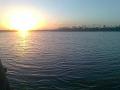
A cool clear night and the dawn brought a little wispy cloud that soon burnt off. The lake had dropped 6 inches overnight, which gives an idea of the amount of water going down the Wellington.
Packed the tent, scrambled around a bit to try to get some shots of the lake (apologies for the quality) and headed off.
 Viewed 19031 times")
- The newer, bigger Tali Karng, at first light
 Viewed 19031 times")
- Ditto
On the way back, I knew when to leave the track - as soon as it turned at headed across that sidecreek, I left it and kept going more or less straight, staying up on the ridge above the river until I could scramble down and join the track below the wet section. Not the easiest but it sure beat trying to follow the official route. (Ferdy couldn't log in until this point, either - too many tall trees around blocking the signal.) Then retrace my steps over the unrecognisable creek and the boring muddy undulations back to the junction and the climb up and over Brandy Pinch.
 Viewed 19031 times")
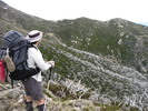
- Margaret from Brandy Pinch