A great weekend walking around the Lake Mackenzie area with one of Blue Peaks bagged and a stay at the large lake next to Middle Lake. Does that lake have a name? The next day this was followed by a walk around the north side of the lake to join up with the Unimog track and out again. Saturday good weather and Sunday rain, followed by heavy rain, followed by heavy wind blown rain, followed by a massive temperature drop and heavy snow. Yeap, Tassie if you do not like the weather wait five minutes.
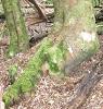
As the only techie on the walk chance to use the GPS with OSM maps and Contour Australia without the crutch of a electronic form of Tasmaps. Had of course the paper map as backup plus a walker well experienced in the area in the group. As the walk took us past an old foundation I took the chance to waypoint the building corners and the centre with the hope that it would show up on Bing so I could have a reference point to align the Bing aerial photograph to. Ok maybe only a mapping freak would find such a foundation exciting.
 Viewed 31423 times")
- Any reference point will do.
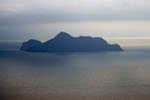
Blue Peak 1 was easily reached as the off track walking in that area is very friendly so managed to dodge the scree and scrub. The view from Blue Peak 1 was great and a chance to play with the waypoint averaging feature of the Garmin 62S. My position differed a little to the one on this site peak list but not by much.
 Viewed 31423 times")
- Not such a bad view to take in while the Garmin does its averaging trick.
So it was on to the camping spot. The old hand took us via the scenic route as memory is not what it used to be was the excuse. I found the tarn on the GPS that I had traced in but it was not the one. Then we found the lake but it was not on my GPS? Um? Did I miss it. Err no, I mucked up and while I had traced it in I did not have it marked as a lake

But what the heck good chance to walk the lake and get the GPS plot plus the waypoints to reference and align Bing with. Err? walking around an alpine lake can have a few challenges but managed not to do a closer in water survey.
 Viewed 31423 times")
- It is a hell of a job checking a lake's position but someone has to do it.
Woke the next day and it was pretty much clagged in. This is where I found the old school versus new school thinking collided. The old school is to reverse the route and using the recent memory to back track. New school was, heck we know where we are so lets strike out for a track and then follow that back. New school won so away we went.
 Viewed 31423 times")
- It was a misty walk but easy to get to the track.
Once on track we encountered a rather well marked secondary track that mislead us. Thanks to the GPS we could back track and take the same way back. As it turned out the "false" track was arguably the better option but we did not know that as heavy snow was falling the and the temperature plummeting. So we made it back to the car.
Now the homework stated with the lakes being aligned to known GPS position, track put into OSM along with the road up to Lake Mackenzie. Still more fix up work required but very happy that home made maps can work well in the real world. Tasmap's track is rather off by over a hundred if not two hundred metres so hopefully the amateur maps are better than the professional ones.
Cheers
"lt only took six years. From now on, l´ll write two letters a week instead of one."
(Shawshank Redemption)