GPSGuided wrote:A Q: Is there a way to come down from Ahearn's Lookout to the Nattai River level without going all the back to the trailhead? NP's site map seemed to suggest that there's a way down from just a little to the north-west of the lookout. Anyone can confirm this?
Firstly, Ahearn Lookout from the Nattai River:
There is no way to get down directly from the lookout. For about the last 2km of the walk out to Ahearn it is all high cliffs. There is a route down on the south side called the Slot Way. It runs down to the river via the Rocky Waterholes Creek valley. I have a waypoint for it somewhere, give me some time and I'll see if I can find it.
On a walk out to Ahearn several years ago one of our party spotted some cairns that led off towards the Starlights track side. (Edit: the cairns were a long way back from the lookout) We didn't have time to see where they went on that trip so on my next trip out there we tried to follow them. The cairns led to a break in the cliffs not far off the Ahearn track. We scrambled down to the next level. After a bit of stuffing around we found a trail of yellow electrical tape that took us to a spot that could be scrambled down which gets you below the cliff line and it appeared possible to scrub bash to the Starlights track. Unfortunately we did not go down this way as I was not confident that some of our party would be able to do the scramble. Maybe one day I'll organise another attempt to see if it is possible to get down to Starlights via this route.
I read somewhere of people coming a long way back along Ahearn to then scramble down to Starlights. Can't remember where I read this.
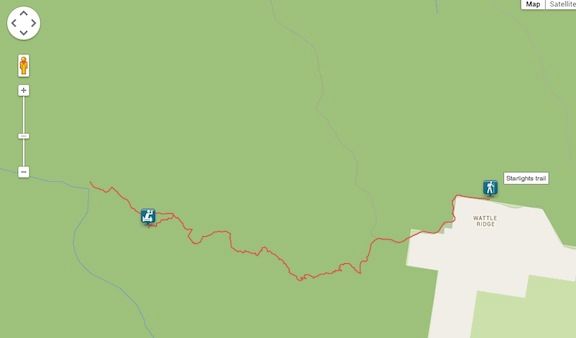
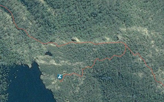
Here are some GPS waypoints for the Ahearn track:
Parking - S34 17.830 E150 25.729.
At the national park information sign there should be a walkers book, you should put your name into the book.
Walk through the gate and continue along Nattai Rd (11E fire trail).
Turn left at the sign for Starlight’s Trail.
Turn left onto Rocky Waterholes Ck Trail – S34 18.225 E150 24.747. There is no sign for this trail but a clear track branches off to the left (south). The right hand branch is the continuation of the Starlight’s Trail.
Turn right onto the Ahearn Lookout Trail at – S34 18.296 E150 24.717. Track heads around Point Hill. Great views from the western side of Point Hill. Good morning tea location. In one spot you can see all the way from Mt Jellore to Yerranderie Peak.
Great lookout just off the main trail here – S34 17.919 E150 23.246
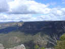
The track will lead you to a spot that has great views across the valley to Russells Needle, Mt Jellore and beyond. A short walk to the north of the end of the trail is Ahearn Lookout proper, which gives great views along the Nattai River valley to the NW including Emmetts Flat.
When you get back make sure you note in the walkers book that you have returned.
Hope this is of some help.
Michael.
One foot in front of the other.