Hey guys,
Just wondering if anyone has an idea for a short (<1.5 hrs) hike in the Grampians to somewhere with good sunrise views?
It's a long shot but thought it might be worth asking.
Cheers
Neil
Grampians - Sunrise short hike?
Forum rules
Victoria specific bushwalking discussion. Please avoid publishing details of access to sensitive areas with no tracks.
Victoria specific bushwalking discussion. Please avoid publishing details of access to sensitive areas with no tracks.
32 posts
• Page 1 of 2 • 1, 2
Grampians - Sunrise short hike?
![]() by neil_fahey » Thu 19 Feb, 2015 5:55 pm
by neil_fahey » Thu 19 Feb, 2015 5:55 pm
-

neil_fahey - Athrotaxis cupressoides

- Posts: 215
- Joined: Mon 14 Dec, 2009 12:30 pm
- Location: Melbourne, Victoria
- ASSOCIATED ORGANISATIONS: BushwalkingBlog.com.au
- Region: Victoria
- Gender: Male
Re: Grampians - Sunrise short hike?
![]() by icefest » Thu 19 Feb, 2015 5:58 pm
by icefest » Thu 19 Feb, 2015 5:58 pm
Pinnacle, Hollow Mtn, Stapylton, Mt zero, Mt william.
Men wanted for hazardous journey. Low wages, bitter cold, long hours of complete darkness. Safe return doubtful.
-
icefest - Lagarostrobos franklinii

- Posts: 4517
- Joined: Fri 27 May, 2011 11:19 pm
- Location: www.canyoninginvictoria.org
- Region: Victoria
Re: Grampians - Sunrise short hike?
![]() by neil_fahey » Thu 19 Feb, 2015 6:07 pm
by neil_fahey » Thu 19 Feb, 2015 6:07 pm
Thanks mate... But are all those less than 1.5 hours?
-
neil_fahey - Athrotaxis cupressoides
- Posts: 215
- Joined: Mon 14 Dec, 2009 12:30 pm
- Location: Melbourne, Victoria
- ASSOCIATED ORGANISATIONS: BushwalkingBlog.com.au
- Region: Victoria
- Gender: Male
Re: Grampians - Sunrise short hike?
![]() by icefest » Thu 19 Feb, 2015 6:14 pm
by icefest » Thu 19 Feb, 2015 6:14 pm
Return, or one way?
Men wanted for hazardous journey. Low wages, bitter cold, long hours of complete darkness. Safe return doubtful.
-
icefest - Lagarostrobos franklinii
- Posts: 4517
- Joined: Fri 27 May, 2011 11:19 pm
- Location: www.canyoninginvictoria.org
- Region: Victoria
Re: Grampians - Sunrise short hike?
![]() by neil_fahey » Thu 19 Feb, 2015 6:37 pm
by neil_fahey » Thu 19 Feb, 2015 6:37 pm
One way. Just dont wanna get up too early! 
-
neil_fahey - Athrotaxis cupressoides
- Posts: 215
- Joined: Mon 14 Dec, 2009 12:30 pm
- Location: Melbourne, Victoria
- ASSOCIATED ORGANISATIONS: BushwalkingBlog.com.au
- Region: Victoria
- Gender: Male
-
neilmny - Lagarostrobos franklinii
- Posts: 2576
- Joined: Fri 03 Aug, 2012 11:19 am
- Region: Victoria
- Gender: Male
Re: Grampians - Sunrise short hike?
![]() by neil_fahey » Thu 19 Feb, 2015 7:38 pm
by neil_fahey » Thu 19 Feb, 2015 7:38 pm
neilmny wrote:Boronia Peak?
That looks like it might be the go! Thank you!
-
neil_fahey - Athrotaxis cupressoides
- Posts: 215
- Joined: Mon 14 Dec, 2009 12:30 pm
- Location: Melbourne, Victoria
- ASSOCIATED ORGANISATIONS: BushwalkingBlog.com.au
- Region: Victoria
- Gender: Male
Re: Grampians - Sunrise short hike?
![]() by Snowzone » Thu 19 Feb, 2015 7:45 pm
by Snowzone » Thu 19 Feb, 2015 7:45 pm
Hi Neil,
anywhere on the Mount William Range would be good as you get the color on the Serra Range. Mount William itself is a short hike if you drive to the carpark but you can head across the the Major Mitchell Plateau if you want to lengthen it. Yes Boronia Peak or Chataqua Peak would also suit your timeframe.
anywhere on the Mount William Range would be good as you get the color on the Serra Range. Mount William itself is a short hike if you drive to the carpark but you can head across the the Major Mitchell Plateau if you want to lengthen it. Yes Boronia Peak or Chataqua Peak would also suit your timeframe.
-
Snowzone - Phyllocladus aspleniifolius

- Posts: 519
- Joined: Sat 11 Dec, 2010 12:10 pm
- Region: Victoria
- Gender: Female
Re: Grampians - Sunrise short hike?
![]() by neil_fahey » Thu 19 Feb, 2015 9:32 pm
by neil_fahey » Thu 19 Feb, 2015 9:32 pm
Thanks snowzone! Added to the list. Will have a think and see how I go.
Cheers
Neil
Cheers
Neil
-
neil_fahey - Athrotaxis cupressoides
- Posts: 215
- Joined: Mon 14 Dec, 2009 12:30 pm
- Location: Melbourne, Victoria
- ASSOCIATED ORGANISATIONS: BushwalkingBlog.com.au
- Region: Victoria
- Gender: Male
-
Eremophila - Phyllocladus aspleniifolius
- Posts: 931
- Joined: Mon 24 Oct, 2011 5:15 pm
- Location: SW Vic
- Region: Victoria
- Gender: Female
Re: Grampians - Sunrise short hike?
![]() by eggs » Sat 21 Feb, 2015 2:46 pm
by eggs » Sat 21 Feb, 2015 2:46 pm
Definitely Mt William. You can drive up till there are only a few kms left to walk, and the view of sunrise lighting up the range to the north is well worth it.
[PS - I did this with a young family - Although my wife with a pram and 2 young kids lagged a bit behind while I was rushing with the camera to the top. ]
]
PPS - Although I also got up Boronia for a sunrise once as well. Nice.
[PS - I did this with a young family - Although my wife with a pram and 2 young kids lagged a bit behind while I was rushing with the camera to the top.
PPS - Although I also got up Boronia for a sunrise once as well. Nice.
-
eggs - Lagarostrobos franklinii
- Posts: 10832
- Joined: Fri 23 May, 2008 2:58 pm
- Location: Para Vista, South Australia
- Region: South Australia
Re: Grampians - Sunrise short hike?
![]() by neil_fahey » Sun 22 Feb, 2015 8:12 pm
by neil_fahey » Sun 22 Feb, 2015 8:12 pm
Hey guys,
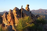
Thanks so much for all the suggestions. Just got back a couple of hours ago and I ended up doing Boronia Peak, well almost. I assume Boronia Peak is the tallest and southernmost of that group of peaks, so I actually watched from the peak just north of that. By the time I got to that one, I decided I'd miss too much if I went any further. Turned out to be a great spot and a gorgeous sunrise, though it could've used a few more clouds to make things interesting. Anyways, absolutely loved the whole experience and will probably go back and do it again somewhere different next time. Really appreciate the help!
Cheers
Neil
-
neil_fahey - Athrotaxis cupressoides
- Posts: 215
- Joined: Mon 14 Dec, 2009 12:30 pm
- Location: Melbourne, Victoria
- ASSOCIATED ORGANISATIONS: BushwalkingBlog.com.au
- Region: Victoria
- Gender: Male
Re: Grampians - Sunrise short hike?
![]() by Lophophaps » Mon 23 Feb, 2015 11:05 am
by Lophophaps » Mon 23 Feb, 2015 11:05 am
Mt Rosea may work. The old track that went up the front is still used by rock climbers and is shorter than the new track, which goes around the back. I have not been up either for a while and am unsure if the old track is marked. It's not too hard coming down, but finding the start may be hard going up.
-
Lophophaps - Auctorita modica

- Posts: 3475
- Joined: Wed 09 Nov, 2011 9:45 am
- Region: Victoria
- Gender: Male
Re: Grampians - Sunrise short hike?
![]() by icefest » Mon 23 Feb, 2015 6:25 pm
by icefest » Mon 23 Feb, 2015 6:25 pm
Lophophaps wrote:Mt Rosea may work. The old track that went up the front is still used by rock climbers and is shorter than the new track, which goes around the back. I have not been up either for a while and am unsure if the old track is marked. It's not too hard coming down, but finding the start may be hard going up.
I think they've cleverly blocked it off with a big log.
Men wanted for hazardous journey. Low wages, bitter cold, long hours of complete darkness. Safe return doubtful.
-
icefest - Lagarostrobos franklinii
- Posts: 4517
- Joined: Fri 27 May, 2011 11:19 pm
- Location: www.canyoninginvictoria.org
- Region: Victoria
Re: Grampians - Sunrise short hike?
![]() by neil_fahey » Mon 23 Feb, 2015 6:45 pm
by neil_fahey » Mon 23 Feb, 2015 6:45 pm
Thank you! Another one to try. Might be worth scoping it out during the daytime first.
-
neil_fahey - Athrotaxis cupressoides
- Posts: 215
- Joined: Mon 14 Dec, 2009 12:30 pm
- Location: Melbourne, Victoria
- ASSOCIATED ORGANISATIONS: BushwalkingBlog.com.au
- Region: Victoria
- Gender: Male
Re: Grampians - Sunrise short hike?
![]() by neil_fahey » Mon 23 Feb, 2015 6:47 pm
by neil_fahey » Mon 23 Feb, 2015 6:47 pm
icefest wrote:Lophophaps wrote:Mt Rosea may work. The old track that went up the front is still used by rock climbers and is shorter than the new track, which goes around the back. I have not been up either for a while and am unsure if the old track is marked. It's not too hard coming down, but finding the start may be hard going up.
I think they've cleverly blocked it off with a big log.
Didn't see this one before my last reply. Well that could post a challenge for those of us hiking in darkness!
-
neil_fahey - Athrotaxis cupressoides
- Posts: 215
- Joined: Mon 14 Dec, 2009 12:30 pm
- Location: Melbourne, Victoria
- ASSOCIATED ORGANISATIONS: BushwalkingBlog.com.au
- Region: Victoria
- Gender: Male
Re: Grampians - Sunrise short hike?
![]() by Lophophaps » Mon 23 Feb, 2015 9:00 pm
by Lophophaps » Mon 23 Feb, 2015 9:00 pm
At Rosea, I can't see climbers taking the back route, especially for climbs to the south or left of the sloping ramp. Rosea is a major climbing destination, and the track would surely be intact, even if it has faded a bit. Approaching the cliff, much is benched. Rock climbers can walk around big logs, unroped. Find the start at the lower end and it should be easy to follow. A recce in daylight is a good idea.
Does anyone know why the old track was closed?
Does anyone know why the old track was closed?
-
Lophophaps - Auctorita modica
- Posts: 3475
- Joined: Wed 09 Nov, 2011 9:45 am
- Region: Victoria
- Gender: Male
Re: Grampians - Sunrise short hike?
![]() by icefest » Mon 23 Feb, 2015 9:49 pm
by icefest » Mon 23 Feb, 2015 9:49 pm
Lophophaps wrote:Does anyone know why the old track was closed?[/color]
I think didn't qualify to the Australian standard required and it was easier building a new track.
The reason for the step up in AS is (I suspect) the plan to include the walk in the new north to south Grampians thru-hike.
Men wanted for hazardous journey. Low wages, bitter cold, long hours of complete darkness. Safe return doubtful.
-
icefest - Lagarostrobos franklinii
- Posts: 4517
- Joined: Fri 27 May, 2011 11:19 pm
- Location: www.canyoninginvictoria.org
- Region: Victoria
Re: Grampians - Sunrise short hike?
![]() by bmak » Mon 23 Feb, 2015 10:12 pm
by bmak » Mon 23 Feb, 2015 10:12 pm
Pinnacle is always a favorite of mine for sunrise. Gives you a bit of extra time for the sun to rise over the eastern range too.
Sunrise and sunset from major Mitchell plateau is something to experience but maybe stretching the 1.5 hrs unless you walk quick
Sunrise and sunset from major Mitchell plateau is something to experience but maybe stretching the 1.5 hrs unless you walk quick
- bmak
- Athrotaxis cupressoides
- Posts: 150
- Joined: Sun 13 Jun, 2010 8:26 pm
- Region: Victoria
- Gender: Male
Re: Grampians - Sunrise short hike?
![]() by peregrinator » Tue 24 Feb, 2015 8:19 am
by peregrinator » Tue 24 Feb, 2015 8:19 am
bmak wrote:Pinnacle is always a favorite of mine for sunrise. Gives you a bit of extra time for the sun to rise over the eastern range too.
Sunrise and sunset from major Mitchell plateau is something to experience but maybe stretching the 1.5 hrs unless you walk quick
Just checked my notes from a recent trip. In no particular hurry, got from Halls Gap to The Pinnacle in 1hr25min. A climb of 470m.
Another statistic was recorded: 44 discarded tissues beside track!
- peregrinator
- Athrotaxis selaginoides

- Posts: 1853
- Joined: Fri 15 Apr, 2011 2:50 pm
- Region: Victoria
Re: Grampians - Sunrise short hike?
![]() by neil_fahey » Tue 24 Feb, 2015 8:56 am
by neil_fahey » Tue 24 Feb, 2015 8:56 am
What's with the tissues? Omfg people suck. :/
-
neil_fahey - Athrotaxis cupressoides
- Posts: 215
- Joined: Mon 14 Dec, 2009 12:30 pm
- Location: Melbourne, Victoria
- ASSOCIATED ORGANISATIONS: BushwalkingBlog.com.au
- Region: Victoria
- Gender: Male
Re: Grampians - Sunrise short hike?
![]() by north-north-west » Sun 01 Mar, 2015 6:33 am
by north-north-west » Sun 01 Mar, 2015 6:33 am
Mt Zero is a pretty short trip from the carpark, and the views over to Stapylton and Hollow from the summit are superb. I've done a sunrise jaunt up there and even in ordinary conditions it'd fit the bill for you.
"Mit der Dummheit kämpfen Götter selbst vergebens."
-

north-north-west - Lagarostrobos franklinii
- Posts: 15487
- Joined: Thu 14 May, 2009 7:36 pm
- Location: The Asylum
- ASSOCIATED ORGANISATIONS: Social Misfits Anonymous
- Region: Tasmania
Re: Grampians - Sunrise short hike?
![]() by neil_fahey » Sun 01 Mar, 2015 7:13 am
by neil_fahey » Sun 01 Mar, 2015 7:13 am
Cheers NNW, will check it out.
-
neil_fahey - Athrotaxis cupressoides
- Posts: 215
- Joined: Mon 14 Dec, 2009 12:30 pm
- Location: Melbourne, Victoria
- ASSOCIATED ORGANISATIONS: BushwalkingBlog.com.au
- Region: Victoria
- Gender: Male
Re: Grampians - Sunrise short hike?
![]() by peregrinator » Sun 08 Mar, 2015 3:20 pm
by peregrinator » Sun 08 Mar, 2015 3:20 pm
icefest wrote:Lophophaps wrote:Mt Rosea may work. The old track that went up the front is still used by rock climbers and is shorter than the new track, which goes around the back. I have not been up either for a while and am unsure if the old track is marked. It's not too hard coming down, but finding the start may be hard going up.
I think they've cleverly blocked it off with a big log.
Lophophaps wrote:At Rosea, I can't see climbers taking the back route, especially for climbs to the south or left of the sloping ramp. Rosea is a major climbing destination, and the track would surely be intact, even if it has faded a bit. Approaching the cliff, much is benched. Rock climbers can walk around big logs, unroped. Find the start at the lower end and it should be easy to follow. A recce in daylight is a good idea.
The start of the old track is obvious (between the 630 and 640 contours) and it still gets foot traffic. It is also very easily identified at the top. But in between those points, I don't know (yet). It's possible that the January 2011 floods and landslips have done some damage. (See Google Maps satellite view showing several slips running down towards Silverband Road.)
John and Lyn Daley's Take a walk in Victoria's National Parks, 2005 reports that it "was closed after being considered dangerous." (I'm guessing that information was conveyed by someone from Parks Vic.) Really? Only if everyone wanted to do it shoeless at midnight. Carrying candles on a windy night.
Anyway, I discovered last week that (1) Mt Rosea does qualify regarding the 1.5 hour approach timeframe (only just), and (2) it has a brilliant views (360 degrees, apart from a few trees hiding most of the Major Mitchell plateau). But I think it might be difficult to reach before sunrise. There are a few spots where the way isn't obvious once you're up on the top.
- peregrinator
- Athrotaxis selaginoides
- Posts: 1853
- Joined: Fri 15 Apr, 2011 2:50 pm
- Region: Victoria
Re: Grampians - Sunrise short hike?
![]() by peregrinator » Sun 08 Mar, 2015 3:34 pm
by peregrinator » Sun 08 Mar, 2015 3:34 pm
peregrinator wrote:bmak wrote:Pinnacle is always a favorite of mine for sunrise. Gives you a bit of extra time for the sun to rise over the eastern range too.
Sunrise and sunset from major Mitchell plateau is something to experience but maybe stretching the 1.5 hrs unless you walk quick
Just checked my notes from a recent trip. In no particular hurry, got from Halls Gap to The Pinnacle in 1hr25min. A climb of 470m.
Clarification. This was the 5.2 km route through the Grandish Canyon, not the 3.4 km route below Mackeys Peak.
- peregrinator
- Athrotaxis selaginoides
- Posts: 1853
- Joined: Fri 15 Apr, 2011 2:50 pm
- Region: Victoria
Re: Grampians - Sunrise short hike?
![]() by neil_fahey » Sun 19 Apr, 2015 3:40 pm
by neil_fahey » Sun 19 Apr, 2015 3:40 pm
Just in case anyone's interested, I've blogged my Boronia Peak sunrise hike here - http://www.bushwalkingblog.com.au/grampians-sunrise-hike-boronia-peak/
-
neil_fahey - Athrotaxis cupressoides
- Posts: 215
- Joined: Mon 14 Dec, 2009 12:30 pm
- Location: Melbourne, Victoria
- ASSOCIATED ORGANISATIONS: BushwalkingBlog.com.au
- Region: Victoria
- Gender: Male
Re: Grampians - Sunrise short hike?
![]() by neilmny » Sun 19 Apr, 2015 4:07 pm
by neilmny » Sun 19 Apr, 2015 4:07 pm
Nice report and pictures Neil.
-
neilmny - Lagarostrobos franklinii
- Posts: 2576
- Joined: Fri 03 Aug, 2012 11:19 am
- Region: Victoria
- Gender: Male
-
neil_fahey - Athrotaxis cupressoides
- Posts: 215
- Joined: Mon 14 Dec, 2009 12:30 pm
- Location: Melbourne, Victoria
- ASSOCIATED ORGANISATIONS: BushwalkingBlog.com.au
- Region: Victoria
- Gender: Male
Re: Grampians - Sunrise short hike?
![]() by Explorer_Sam » Wed 06 May, 2015 11:54 am
by Explorer_Sam » Wed 06 May, 2015 11:54 am
Eremophila wrote:Mt Abrupt?
Mount Abrupt was perfect. Woke up at 3:30 am and drove from Hamilton then walked up in time for the sunrise. Had bacon on top too!
My Blog- Adventure and Nature Writing- www.sambochristie.wordpress.com
- Explorer_Sam
- Athrotaxis cupressoides
- Posts: 313
- Joined: Thu 01 Mar, 2012 8:33 pm
- Location: Maryborough
- Region: Victoria
- Gender: Male
Re: Grampians - Sunrise short hike?
![]() by neil_fahey » Thu 16 Jul, 2015 10:21 am
by neil_fahey » Thu 16 Jul, 2015 10:21 am
Bacon!? Now that's a solid addition to my next sunrise hike plan. Doing it.
-
neil_fahey - Athrotaxis cupressoides
- Posts: 215
- Joined: Mon 14 Dec, 2009 12:30 pm
- Location: Melbourne, Victoria
- ASSOCIATED ORGANISATIONS: BushwalkingBlog.com.au
- Region: Victoria
- Gender: Male
32 posts
• Page 1 of 2 • 1, 2
Who is online
Users browsing this forum: No registered users and 1 guest