Hi
I introduced myself on intro section, I live in Melbourne and do the occasional bushwalking/camp activities.
I recently bought the Suunto M3 for navigation but usually to initially plot my route on topo map and use the compass to finish my walk.
I now want to try and experiment with taking some spot bearings along the way to triangulate my position.
So the big question is declination adjustment?
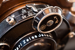
I currently have my declination set to ~11 deg East as shown on the photo. When I take a bearing to transfer to map, do I need to reverse the declination ie add 11 deg?
Cheers and thanks in advance
Declination adjustment - Suunto M3
Forum rules
TIP: The online Bushwalk Inventory System can help bushwalkers with a variety of bushwalk planning tasks, including: Manage which items they take bushwalking so that they do not forget anything they might need, plan meals for their walks, and automatically compile food/fuel shopping lists (lists of consumables) required to make and cook the meals for each walk. It is particularly useful for planning for groups who share food or other items, but is also useful for individual walkers.
TIP: The online Bushwalk Inventory System can help bushwalkers with a variety of bushwalk planning tasks, including: Manage which items they take bushwalking so that they do not forget anything they might need, plan meals for their walks, and automatically compile food/fuel shopping lists (lists of consumables) required to make and cook the meals for each walk. It is particularly useful for planning for groups who share food or other items, but is also useful for individual walkers.
16 posts
• Page 1 of 1
-

Defender110 - Nothofagus gunnii

- Posts: 12
- Joined: Mon 03 Aug, 2015 4:39 pm
- Region: Victoria
- Gender: Male
Re: Declination adjustment - Suunto M3
![]() by scoha » Mon 03 Aug, 2015 7:13 pm
by scoha » Mon 03 Aug, 2015 7:13 pm
Ive always used "Grandma SUX" to guide me (sorry this sounds so wrong). Grid to Magnetic Subtract. In this instance you are going from Magnetic to Grid so you add - I think - happy to stand corrected
- scoha
- Athrotaxis cupressoides

- Posts: 110
- Joined: Thu 30 Oct, 2014 5:59 pm
- Region: Victoria
- Gender: Male
Re: Declination adjustment - Suunto M3
![]() by Strider » Mon 03 Aug, 2015 7:26 pm
by Strider » Mon 03 Aug, 2015 7:26 pm
Scoha you are correct but I believe as DF110 has adjusted his compass to allow for magnetic declination that no further adjustment should be necessary. Again, happy to be corrected!
Sent from my SM-N9005 using Tapatalk
Sent from my SM-N9005 using Tapatalk
-
Strider - Lagarostrobos franklinii

- Posts: 5875
- Joined: Mon 07 Nov, 2011 6:55 pm
- Location: Point Cook
- Region: Victoria
- Gender: Male
Declination adjustment - Suunto M3
![]() by Defender110 » Mon 03 Aug, 2015 8:11 pm
by Defender110 » Mon 03 Aug, 2015 8:11 pm
Strider wrote:Scoha you are correct but I believe as DF110 has adjusted his compass to allow for magnetic declination that no further adjustment should be necessary. Again, happy to be corrected!
Sent from my SM-N9005 using Tapatalk
Strider, I have a feeling you maybe have a point but, I will need to try the triangulation on known areas to test this out.
Sent from my iPad using Tapatalk
-
Defender110 - Nothofagus gunnii
- Posts: 12
- Joined: Mon 03 Aug, 2015 4:39 pm
- Region: Victoria
- Gender: Male
Re: Declination adjustment - Suunto M3
![]() by GPSGuided » Mon 03 Aug, 2015 10:36 pm
by GPSGuided » Mon 03 Aug, 2015 10:36 pm
I use one too.
That's the beauty of a compass with declination adjustment. Once done, there's no need to do any more arithmetics if you just work with grid north as all bearings (on compass or off the map) are all grid north based. You'll only need to do the arithmetics if someone gives you a bearing based on magnetic north or you need to reference a bearing based on magnetic north. Don't bother, just let others do the math.
That's the beauty of a compass with declination adjustment. Once done, there's no need to do any more arithmetics if you just work with grid north as all bearings (on compass or off the map) are all grid north based. You'll only need to do the arithmetics if someone gives you a bearing based on magnetic north or you need to reference a bearing based on magnetic north. Don't bother, just let others do the math.
Just move it!
-
GPSGuided - Lagarostrobos franklinii
- Posts: 6801
- Joined: Mon 13 May, 2013 2:37 pm
- Location: Sydney
- Region: New South Wales
Re: Declination adjustment - Suunto M3
![]() by photohiker » Mon 03 Aug, 2015 10:50 pm
by photohiker » Mon 03 Aug, 2015 10:50 pm
There are two ways of doing this.
You either make the adjustment on the compass if it has declination adjustment (and you want to use it), or you make the adjustment on the fly. If your compass is already adjusted, making further adjustments on the fly is going to put you way off track. The grid lines on your map will be true north, not magnetic north, the map should show the magnetic declination at time of print.
Otherwise, why would the declination adjustment even exist on the compass?
Nice compass
Here's a short video that puts the basics together:
The video is US based, you can get the Australian declination here: http://www.ga.gov.au/oracle/geomag/agrfform.jsp
Your 11 degrees is about right for Melbourne
Michael
-
photohiker - Lagarostrobos franklinii
- Posts: 3097
- Joined: Sun 17 May, 2009 12:31 pm
- Location: Adelaide, dreaming up where to go next.
Re: Declination adjustment - Suunto M3
![]() by GPSGuided » Mon 03 Aug, 2015 10:58 pm
by GPSGuided » Mon 03 Aug, 2015 10:58 pm
This following site may be a bit easier to use.
http://www.magnetic-declination.com
http://www.magnetic-declination.com
Just move it!
-
GPSGuided - Lagarostrobos franklinii
- Posts: 6801
- Joined: Mon 13 May, 2013 2:37 pm
- Location: Sydney
- Region: New South Wales
Re: Declination adjustment - Suunto M3
![]() by photohiker » Mon 03 Aug, 2015 10:58 pm
by photohiker » Mon 03 Aug, 2015 10:58 pm
Also, there's several threads about declination and compasses.
Here's one that might help: viewtopic.php?f=5&t=9023
Here's one that might help: viewtopic.php?f=5&t=9023
Michael
-
photohiker - Lagarostrobos franklinii
- Posts: 3097
- Joined: Sun 17 May, 2009 12:31 pm
- Location: Adelaide, dreaming up where to go next.
Re: Declination adjustment - Suunto M3
![]() by Defender110 » Tue 04 Aug, 2015 8:02 am
by Defender110 » Tue 04 Aug, 2015 8:02 am
photohiker wrote:There are two ways of doing this.
You either make the adjustment on the compass if it has declination adjustment (and you want to use it), or you make the adjustment on the fly. If your compass is already adjusted, making further adjustments on the fly is going to put you way off track. The grid lines on your map will be true north, not magnetic north, the map should show the magnetic declination at time of print.
Otherwise, why would the declination adjustment even exist on the compass?
Nice compass
Here's a short video that puts the basics together:
The video is US based, you can get the Australian declination here: http://www.ga.gov.au/oracle/geomag/agrfform.jsp
Your 11 degrees is about right for Melbourne
The 11deg was set for Blackwood Victoria when I was doing a bushwalking locating some of the disused mines. I am using the government site to get the updated declination for specific location.
I used to use an older Suunto to navigate but never bothered with declination, I always used to find my way back sometimes a bit off course but never got lost.
I now decided to apply a bit of science so my sons can learn instead of relying on GPS.
Sent from my iPad using Tapatalk
-
Defender110 - Nothofagus gunnii
- Posts: 12
- Joined: Mon 03 Aug, 2015 4:39 pm
- Region: Victoria
- Gender: Male
Re: Declination adjustment - Suunto M3
![]() by andrewp » Tue 04 Aug, 2015 8:38 am
by andrewp » Tue 04 Aug, 2015 8:38 am
No-one has mentioned the grid convergence. The grid lines on Australian maps are not aligned to true north. It is not the magnetic declination that you need to adjust for, it is the grid magnetic angle.
For example at Blackwood, Victoria:
Magnetic declination 11.18
Grid convergence -1.64
Grid magnetic angle 9.54
In answer to the OP, if you set the compass declination to the grid magnetic angle you will not have to do any further calculations when taking bearings off the map, or using compass bearings to do triangulations on the map.
However, IMO it can be dangerous to set your compass like this. I have the same compass but never use this feature. I had a friend who had been to WA and set his compass. Came back to Victoria and forgot to change it and wondered why he was 15 degrees out.
- map_magnetic_declination.gif (5.07 KiB) Viewed 6103 times
For example at Blackwood, Victoria:
Magnetic declination 11.18
Grid convergence -1.64
Grid magnetic angle 9.54
In answer to the OP, if you set the compass declination to the grid magnetic angle you will not have to do any further calculations when taking bearings off the map, or using compass bearings to do triangulations on the map.
However, IMO it can be dangerous to set your compass like this. I have the same compass but never use this feature. I had a friend who had been to WA and set his compass. Came back to Victoria and forgot to change it and wondered why he was 15 degrees out.
-
andrewp - Athrotaxis cupressoides
- Posts: 312
- Joined: Mon 29 Aug, 2011 10:34 am
- Region: Victoria
- Gender: Male
Re: Declination adjustment - Suunto M3
![]() by GPSGuided » Tue 04 Aug, 2015 9:05 am
by GPSGuided » Tue 04 Aug, 2015 9:05 am
Good detail Andrewp. But for practical purposes out there, most would just use the magnetic declination as it typically only varies with the grid magnetic angle by around 1 deg or less, well within the resolution of bush navigation requirements. Apart from maps, there's no readily available source for grid convergence data on the net that I can find. Understand it's map/region specific.
Just move it!
-
GPSGuided - Lagarostrobos franklinii
- Posts: 6801
- Joined: Mon 13 May, 2013 2:37 pm
- Location: Sydney
- Region: New South Wales
Re: Declination adjustment - Suunto M3
![]() by Defender110 » Tue 04 Aug, 2015 9:14 am
by Defender110 » Tue 04 Aug, 2015 9:14 am
Andrewp, thanks for advice. I thought 1 deg will not make a lot of difference to the type of navigation am doing but for completeness I will be including grid convergence in my settings.
What I will be doing though, experiment using this compass same way as my old one which did not have declination adjustment. I may have to buy a book on navigation and learn the proper way.
Cheers
Sent from my iPad using Tapatalk
What I will be doing though, experiment using this compass same way as my old one which did not have declination adjustment. I may have to buy a book on navigation and learn the proper way.
Cheers
Sent from my iPad using Tapatalk
-
Defender110 - Nothofagus gunnii
- Posts: 12
- Joined: Mon 03 Aug, 2015 4:39 pm
- Region: Victoria
- Gender: Male
Re: Declination adjustment - Suunto M3
![]() by photohiker » Tue 04 Aug, 2015 10:45 am
by photohiker » Tue 04 Aug, 2015 10:45 am
Good point about the grid vs true north variation, Andrew.
I don't agree about using the declination feature as 'dangerous'. Declination is a fact of life when using a compass, ignoring it with or without an adjustable compass can stuff up your navigation.
The beauty of the adjustable compass is that you set it once at the beginning of your trip and you don't have to bother about it for the rest of the trip.
Michael
-
photohiker - Lagarostrobos franklinii
- Posts: 3097
- Joined: Sun 17 May, 2009 12:31 pm
- Location: Adelaide, dreaming up where to go next.
Re: Declination adjustment - Suunto M3
![]() by GPSGuided » Tue 04 Aug, 2015 11:15 am
by GPSGuided » Tue 04 Aug, 2015 11:15 am
I agree that it's hardly 'dangerous'. It's incompetence that's dangerous. It's a tool and convenience tool (avoids incorrect arithmetic errors) and the user should be familiar with it and know the routine in use. As a matter of fact, once trained up, it's more likely to be life saving than dangerous.
Just move it!
-
GPSGuided - Lagarostrobos franklinii
- Posts: 6801
- Joined: Mon 13 May, 2013 2:37 pm
- Location: Sydney
- Region: New South Wales
Re: Declination adjustment - Suunto M3
![]() by GBW » Tue 04 Aug, 2015 11:50 am
by GBW » Tue 04 Aug, 2015 11:50 am
andrewp wrote:No-one has mentioned the grid convergence. The grid lines on Australian maps are not aligned to true north. It is not the magnetic declination that you need to adjust for, it is the grid magnetic angle.
For example at Blackwood, Victoria:
Magnetic declination 11.18
Grid convergence -1.64
Grid magnetic angle 9.54
In answer to the OP, if you set the compass declination to the grid magnetic angle you will not have to do any further calculations when taking bearings off the map, or using compass bearings to do triangulations on the map.
However, IMO it can be dangerous to set your compass like this. I have the same compass but never use this feature. I had a friend who had been to WA and set his compass. Came back to Victoria and forgot to change it and wondered why he was 15 degrees out.
Forgetting to set declination is as bad as forgetting your maps IMO and unlikely to happen. I have the same Suunto and it's an excellent compass. Correct me if I'm wrong but I think grid lines are aligned true north if you are on the central meridian of your zone and convergence increases/decreases as you approach the east/west boundaries.
"If you wish to make an apple pie from scratch, you must first invent the universe"
-

GBW - Athrotaxis selaginoides

- Posts: 1175
- Joined: Fri 02 May, 2014 9:03 am
- Location: Melbourne
- Region: Victoria
- Gender: Male
Re: Declination adjustment - Suunto M3
![]() by andrewp » Tue 04 Aug, 2015 10:15 pm
by andrewp » Tue 04 Aug, 2015 10:15 pm
GBW wrote:Correct me if I'm wrong but I think grid lines are aligned true north if you are on the central meridian of your zone and convergence increases/decreases as you approach the east/west boundaries.
Yes you are correct, so the grid convergence varies from -1.9 to +1.9 degrees.
photohiker wrote:I don't agree about using the declination feature as 'dangerous'.
Yes dangerous is probably an exaggeration, but could get the careless into trouble.
GPSGuided wrote:But for practical purposes out there, most would just use the magnetic declination as it typically only varies with the grid magnetic angle by around 1 deg or less, well within the resolution of bush navigation requirements. Apart from maps, there's no readily available source for grid convergence data on the net that I can find. Understand it's map/region specific.
Well it can be almost 2 degrees and with my navigation skills I like to at least start with the correct bearing. I think the same convergence would apply to all maps based on the UTM projection. There are several websites that calculate grid convergence, but they generally require a grid reference or lat/lon. I have created a calculator using Google maps on a bushwalking website, but at the moment it is only available for members.
-
andrewp - Athrotaxis cupressoides
- Posts: 312
- Joined: Mon 29 Aug, 2011 10:34 am
- Region: Victoria
- Gender: Male
16 posts
• Page 1 of 1
Who is online
Users browsing this forum: No registered users and 33 guests