Thanks johnsj
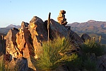
The pyramid frames with circles on top are TRIG POINTs. They were/are used for surveying.
It is generally placed on the highest point around so that surveyors could take bearings on it to establish their relative position and height.
The square cutting in rock at Tourilie Gorge [which you have called Caroona] is where the old road went. It is a road cutting.
Loved the lizard on the fence

Pattersons Curse is also known as Salvation Jane. An imported plant, its name depends on whether you are a cattleman or a bee keeper.
We also have Blue Tongue lizards as distinct from Shinglebacks. [I have always called the Shinglebacks "Stumpy Tailed lizards"]
I have posted a few reports on sections of the Heysen Trail we have done. I am local and it is where we tend to go for winter hiking, but I do prefer to steer clear of the road sections.