He has set a way point for Lake Curly?
Regards OLM
https://eur-share.inreach.garmin.com/louphi
http://www.louis-philippe-loncke.com
That Mad Belgian
Forum rules
Tasmania specific bushwalking discussion. Please avoid publishing details of access to sensitive areas with no tracks.
Tasmania specific bushwalking discussion. Please avoid publishing details of access to sensitive areas with no tracks.
- Overlandman
- Athrotaxis selaginoides

- Posts: 1670
- Joined: Sun 13 Nov, 2011 5:22 pm
- Location: Tasmania
- Region: Tasmania
- Gender: Male
Re: That Mad Belgian
![]() by jmac » Tue 04 Sep, 2018 5:05 pm
by jmac » Tue 04 Sep, 2018 5:05 pm
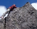
Yes, in which case he would have been better to push on to the clearer line near Battlement, virtually scrub-free that way. Looks like he's going up the Gell Valley floor, a slightly scrubber choice, but an improvement over the last few days' terrain.
- jmac
- Athrotaxis cupressoides

- Posts: 175
- Joined: Wed 11 Nov, 2009 11:03 am
- Region: Tasmania
- Gender: Male
Re: That Mad Belgian
![]() by Overlandman » Tue 04 Sep, 2018 7:50 pm
by Overlandman » Tue 04 Sep, 2018 7:50 pm
4 Sept. Dried tent, sleeping bag and clothes in the sun. Found a rusted chaintractor on old airstrip #2. Steep down to Gell river. Needed water. Crossed, walked and crossed again.
Whatever, Wherever, Whenever
- Overlandman
- Athrotaxis selaginoides
- Posts: 1670
- Joined: Sun 13 Nov, 2011 5:22 pm
- Location: Tasmania
- Region: Tasmania
- Gender: Male
Re: That Mad Belgian
![]() by Guido » Tue 04 Sep, 2018 9:23 pm
by Guido » Tue 04 Sep, 2018 9:23 pm
The chaintractor, photo from from someone's facebook.
- Attachments
-
-
Guido - Nothofagus gunnii

- Posts: 26
- Joined: Wed 24 May, 2017 4:45 pm
- Location: Netherlands
- Region: Other Country
- Gender: Male
Re: That Mad Belgian
![]() by Warin » Tue 04 Sep, 2018 9:39 pm
by Warin » Tue 04 Sep, 2018 9:39 pm
Looks like he has set a way mark at Lake Curly.
Possibly to keep himself on a directional heading?
Have to wait and see where he starts (and when) from tomorrow.
Possibly to keep himself on a directional heading?
Have to wait and see where he starts (and when) from tomorrow.
-
Warin - Athrotaxis selaginoides
- Posts: 1464
- Joined: Sat 11 Nov, 2017 8:02 am
- Region: New South Wales
Re: That Mad Belgian
![]() by MrWalker » Wed 05 Sep, 2018 8:47 am
by MrWalker » Wed 05 Sep, 2018 8:47 am
I see that he was late starting yesterday due to drying everything.
But today will be a day he does his stress test. This is supposed to take half an hour, but the days he does these he rarely gets going before midday. So don't expect an early start today.
But today will be a day he does his stress test. This is supposed to take half an hour, but the days he does these he rarely gets going before midday. So don't expect an early start today.
- MrWalker
- Phyllocladus aspleniifolius

- Posts: 512
- Joined: Fri 25 Nov, 2011 11:14 am
- Region: Tasmania
- Gender: Male
Re: That Mad Belgian
![]() by Mechanic-AL » Wed 05 Sep, 2018 9:47 am
by Mechanic-AL » Wed 05 Sep, 2018 9:47 am
He started out with 65kg on his back, he has walked half the length of the state .....in the winter, a fair bit of it off track,
and he still needs to do a STRESS TEST
Is there something I'm missing here ???
and he still needs to do a STRESS TEST
Is there something I'm missing here ???
"What went ye out into the wilderness to see?
A reed shaken in the wind"?
A reed shaken in the wind"?
- Mechanic-AL
- Athrotaxis cupressoides
- Posts: 432
- Joined: Tue 24 Sep, 2013 7:38 pm
- Region: Western Australia
- Gender: Male
Re: That Mad Belgian
![]() by DanR » Wed 05 Sep, 2018 10:25 am
by DanR » Wed 05 Sep, 2018 10:25 am
I met Louis-Philippe while I was walking to OL track. He was down to 46kg by that stage. Interesting guy.
-
DanR - Nothofagus gunnii
- Posts: 32
- Joined: Mon 01 Aug, 2016 10:10 pm
- Location: Hobart
- Region: Tasmania
- Gender: Male
Re: That Mad Belgian
![]() by GPSGuided » Wed 05 Sep, 2018 10:36 am
by GPSGuided » Wed 05 Sep, 2018 10:36 am
Wow, epic! No wonder he had the ‘European Adventurer of the Year’ title in 2016.
Anyone going to join him for the final leg?
Anyone going to join him for the final leg?
Just move it!
-
GPSGuided - Lagarostrobos franklinii

- Posts: 6801
- Joined: Mon 13 May, 2013 2:37 pm
- Location: Sydney
- Region: New South Wales
Re: That Mad Belgian
![]() by jmac » Wed 05 Sep, 2018 10:48 am
by jmac » Wed 05 Sep, 2018 10:48 am
The tests involve a series of cognitive and decision-making questions that he undertakes in a small booklet prepared for him by a Parisian psychological academic as part of her research project on decision-making and cognitive abilities under stress. If you drill into his blog I think there's a post featuring his collaboration with her.
- jmac
- Athrotaxis cupressoides
- Posts: 175
- Joined: Wed 11 Nov, 2009 11:03 am
- Region: Tasmania
- Gender: Male
Re: That Mad Belgian
![]() by north-north-west » Wed 05 Sep, 2018 11:13 am
by north-north-west » Wed 05 Sep, 2018 11:13 am
jmac wrote:Yes, in which case he would have been better to push on to the clearer line near Battlement, virtually scrub-free that way. Looks like he's going up the Gell Valley floor, a slightly scrubber choice, but an improvement over the last few days' terrain.
A slight divergence if I may: Battlement and Innes High Rocky are on my hit list, but I've not been north of Bonds before - what's the best line between them (ie least scrub)? I've been eyeing off that long spur running wsw from the river valley to just south of IHR. Is it a viable route?
"Mit der Dummheit kämpfen Götter selbst vergebens."
-

north-north-west - Lagarostrobos franklinii
- Posts: 15469
- Joined: Thu 14 May, 2009 7:36 pm
- Location: The Asylum
- ASSOCIATED ORGANISATIONS: Social Misfits Anonymous
- Region: Tasmania
Re: That Mad Belgian
![]() by jmac » Wed 05 Sep, 2018 11:45 am
by jmac » Wed 05 Sep, 2018 11:45 am
There is a pad between Bonds and the plain north of North Star. I suggest you do Battlement from there as an out and back half-day. I'm afraid I lounged in the tent there while my friend Matt Brain did Battlement Hills solo. He said that it was mostly completely clear, especially the burned patch which is obvious on the satellite imagery.
Continue on to enjoy the stunning Curly area; then on to The Font for the Spires. I did IHR as an out and back day from The Font; all clear button grass, all good. Alternatively Matt highly recommends the ridge you mentioned up to near IHR from the Gell Valley if you are coming from that direction. It's the ridge we showed Lou-Phi on the map. I haven't been north of IHR but Matt once pushed all the way from the second airstrip to The Font via IHR in one day. Same on return to Butler's Gorge; so it is a viable line for strong fast walkers.
Continue on to enjoy the stunning Curly area; then on to The Font for the Spires. I did IHR as an out and back day from The Font; all clear button grass, all good. Alternatively Matt highly recommends the ridge you mentioned up to near IHR from the Gell Valley if you are coming from that direction. It's the ridge we showed Lou-Phi on the map. I haven't been north of IHR but Matt once pushed all the way from the second airstrip to The Font via IHR in one day. Same on return to Butler's Gorge; so it is a viable line for strong fast walkers.
- jmac
- Athrotaxis cupressoides
- Posts: 175
- Joined: Wed 11 Nov, 2009 11:03 am
- Region: Tasmania
- Gender: Male
Re: That Mad Belgian
![]() by north-north-west » Wed 05 Sep, 2018 11:54 am
by north-north-west » Wed 05 Sep, 2018 11:54 am
Thank you.
Strong and fast I am not. Just stubborn.
Yeah, I know about the pad down to Badger Flat, but the idea is to try to do a loop from near Bonds if possible. North to BH, across to wherever, IHR and Flame, down to the lake and climb Curly (or reach the lake via Shining, Conical and Curly just to revisit the best campsite I've ever had), back via the flats with a sidetrip up North Star. That's the theory, anyway. These things seldom work as well on the ground as the maps and sat images suggest they will.
"Mit der Dummheit kämpfen Götter selbst vergebens."
-
north-north-west - Lagarostrobos franklinii
- Posts: 15469
- Joined: Thu 14 May, 2009 7:36 pm
- Location: The Asylum
- ASSOCIATED ORGANISATIONS: Social Misfits Anonymous
- Region: Tasmania
Re: That Mad Belgian
![]() by jmac » Wed 05 Sep, 2018 4:29 pm
by jmac » Wed 05 Sep, 2018 4:29 pm
Received via direct message at 3:10 PM: Gell to lake curly. Then up to ridge,3 small lake,then safe down to west pokana bay. No reverend creek. Right? News of the world? trump president?
I looked at the options from his reported position at that time and sent these 4 (reply messages must be limited to 160 characters). I hope I haven't blown his monthly data allowance!
1) Gell-Curly yes. Up bare slabs to MtCurly east shoulder; should be cairns/pad. Don't traverse Curly to 3 lakes. Better to drop off south of Curly to Badger Flat.
2) Follow clear lines across southern Badger Flat to either Pokana Peak or direct to the unnamed junction peak at 42°33'46.43"S 146°10'43.49"E then W Pokana Bay
3) Yes no Reverend Ck from current position. You could avoid Curly completely and go Gell - North Badger Flat - South Badger Flat direct. Lumpy button grass only.
4) Great work Lou-Phi; many people urging you on to success. Stay motivated and look after yourself. No new President, otherwise the world is well. Cheers, John
I probably could have worded those better, but do others concur with the general ideas?
Cheers, J.
- jmac
- Athrotaxis cupressoides
- Posts: 175
- Joined: Wed 11 Nov, 2009 11:03 am
- Region: Tasmania
- Gender: Male
Re: That Mad Belgian
![]() by jmac » Wed 05 Sep, 2018 4:34 pm
by jmac » Wed 05 Sep, 2018 4:34 pm
16:28 PM: "Ok,east of curly. Go to flat, no steep contour lines. Low altitude=water. Then up to your gps peak. Then see safe fast way to bay. Thx"
- jmac
- Athrotaxis cupressoides
- Posts: 175
- Joined: Wed 11 Nov, 2009 11:03 am
- Region: Tasmania
- Gender: Male
Re: That Mad Belgian
![]() by north-north-west » Wed 05 Sep, 2018 5:57 pm
by north-north-west » Wed 05 Sep, 2018 5:57 pm
jmac wrote:Received via direct message at 3:10 PM: Gell to lake curly. Then up to ridge,3 small lake,then safe down to west pokana bay. No reverend creek. Right? News of the world? trump president?
I looked at the options from his reported position at that time and sent these 4 (reply messages must be limited to 160 characters). I hope I haven't blown his monthly data allowance!
1) Gell-Curly yes. Up bare slabs to MtCurly east shoulder; should be cairns/pad. Don't traverse Curly to 3 lakes. Better to drop off south of Curly to Badger Flat.
2) Follow clear lines across southern Badger Flat to either Pokana Peak or direct to the unnamed junction peak at 42°33'46.43"S 146°10'43.49"E then W Pokana Bay
3) Yes no Reverend Ck from current position. You could avoid Curly completely and go Gell - North Badger Flat - South Badger Flat direct. Lumpy button grass only.
4) Great work Lou-Phi; many people urging you on to success. Stay motivated and look after yourself. No new President, otherwise the world is well. Cheers, John
I probably could have worded those better, but do others concur with the general ideas?
Cheers, J.
Don't know the area well enough to say much, although a lot of that lower ground looked a bit scrubby from up on high, though I suppose it can't be any worse than the Pleiades ridge. From what I've seen of Curly I agree that traversing it in this situation is a lot of wasted effort.
(ps: President or not, the world is pretty sucky and getting suckier all the time.
edit: Ahhhh, you mean the bump at the Pokana turnoff? Yeah, that does make sense. Still a bit of climbing but easier than Curly.
"Mit der Dummheit kämpfen Götter selbst vergebens."
-
north-north-west - Lagarostrobos franklinii
- Posts: 15469
- Joined: Thu 14 May, 2009 7:36 pm
- Location: The Asylum
- ASSOCIATED ORGANISATIONS: Social Misfits Anonymous
- Region: Tasmania
Re: That Mad Belgian
![]() by MrWalker » Wed 05 Sep, 2018 8:43 pm
by MrWalker » Wed 05 Sep, 2018 8:43 pm
I'm a bit worried that he might not make it through the 60 days or so required.
LouPhi said
"5 Sept. My legs are so skinny, almost no power. Still some belly fat left, though. Weather mostly sunny. Terrain is better. Made navigation error to wrong mountain. Had a nice 2m roll, fell on my head, back, legs, but all ok."
He did just over 3km south and at that rate might be able to finish at Cockle Creek with 1 day of food left over, if he started with 60 days and is not held up by the weather. And he wasn't affected much by the snow before, so a week of rain coming up shouldn't bother him.
- MrWalker
- Phyllocladus aspleniifolius
- Posts: 512
- Joined: Fri 25 Nov, 2011 11:14 am
- Region: Tasmania
- Gender: Male
Re: That Mad Belgian
![]() by jmac » Wed 05 Sep, 2018 9:46 pm
by jmac » Wed 05 Sep, 2018 9:46 pm
I agree, the loss of muscle mass is a concern. He's not had enough protein for weeks, and he's likely metabolising muscle for energy. Yes his daily progress has been modest lately; since the O/T really. If it deteriorates further he'll need to adjust his objective for sure.
Because of the forecast rain I sent a further message earlier this evening suggesting a first-light start to gain maximal distance before the worst of it. It will be very interesting to observe his progress tomorrow.
Because of the forecast rain I sent a further message earlier this evening suggesting a first-light start to gain maximal distance before the worst of it. It will be very interesting to observe his progress tomorrow.
- jmac
- Athrotaxis cupressoides
- Posts: 175
- Joined: Wed 11 Nov, 2009 11:03 am
- Region: Tasmania
- Gender: Male
Re: That Mad Belgian
![]() by Overlandman » Thu 06 Sep, 2018 8:03 am
by Overlandman » Thu 06 Sep, 2018 8:03 am
Only took 34 days to make the press.
Hopefully Lou-Phi will make it out ok.
What’s his shortest route?
http://www.abc.net.au/news/2018-09-06/t ... e/10194388
Hopefully Lou-Phi will make it out ok.
What’s his shortest route?
http://www.abc.net.au/news/2018-09-06/t ... e/10194388
Last edited by Overlandman on Thu 06 Sep, 2018 8:22 am, edited 2 times in total.
Whatever, Wherever, Whenever
- Overlandman
- Athrotaxis selaginoides
- Posts: 1670
- Joined: Sun 13 Nov, 2011 5:22 pm
- Location: Tasmania
- Region: Tasmania
- Gender: Male
Re: That Mad Belgian
![]() by MrWalker » Thu 06 Sep, 2018 8:14 am
by MrWalker » Thu 06 Sep, 2018 8:14 am
Overlandman wrote:Only took 34 days
http://www.abc.net.au/news/2018-09-06/t ... e/10194388
Now the poor bloke is going to feel obliged to finish, even if he does the South Coast Track without food.
And I expect that after two weeks without seeing anyone, he'll be greeted by a crowd of thousands as he crosses between lake Gordon and Lake Pedder.
- MrWalker
- Phyllocladus aspleniifolius
- Posts: 512
- Joined: Fri 25 Nov, 2011 11:14 am
- Region: Tasmania
- Gender: Male
Re: That Mad Belgian
![]() by GPSGuided » Thu 06 Sep, 2018 9:53 am
by GPSGuided » Thu 06 Sep, 2018 9:53 am
Where’s Bear Grylls for some survival food advice for the final leg? Our friend here needs some of the ‘good protein’ Bear always brag about.
What wild food could our friend find down that part of Tassie?
What wild food could our friend find down that part of Tassie?
Just move it!
-
GPSGuided - Lagarostrobos franklinii
- Posts: 6801
- Joined: Mon 13 May, 2013 2:37 pm
- Location: Sydney
- Region: New South Wales
Re: That Mad Belgian
![]() by north-north-west » Thu 06 Sep, 2018 10:04 am
by north-north-west » Thu 06 Sep, 2018 10:04 am
Wow! He got moving around 9 this morning. If he can keep going all day he should put a real dent in the leg to Pokana Bay.
It's pretty well all NP and/or WHA, so technically all native plant and animal life is protected. Best go would be to hook a few of those monster trout in the impoundments. He probably doesn't have a fishing licence but I doubt anyone would grudge him a little shady piscine protein.
GPSGuided wrote:What wild food could our friend find down that part of Tassie?
It's pretty well all NP and/or WHA, so technically all native plant and animal life is protected. Best go would be to hook a few of those monster trout in the impoundments. He probably doesn't have a fishing licence but I doubt anyone would grudge him a little shady piscine protein.
"Mit der Dummheit kämpfen Götter selbst vergebens."
-
north-north-west - Lagarostrobos franklinii
- Posts: 15469
- Joined: Thu 14 May, 2009 7:36 pm
- Location: The Asylum
- ASSOCIATED ORGANISATIONS: Social Misfits Anonymous
- Region: Tasmania
Re: That Mad Belgian
![]() by GPSGuided » Thu 06 Sep, 2018 10:09 am
by GPSGuided » Thu 06 Sep, 2018 10:09 am
No grubs? How about jumping ants as protein source? A wild trout would be a feast for him right now...
Just move it!
-
GPSGuided - Lagarostrobos franklinii
- Posts: 6801
- Joined: Mon 13 May, 2013 2:37 pm
- Location: Sydney
- Region: New South Wales
Re: That Mad Belgian
![]() by doogs » Thu 06 Sep, 2018 12:24 pm
by doogs » Thu 06 Sep, 2018 12:24 pm
His progress has been worryingly slow recently. I hope he's ok out there.
Do you want to build a snowman?
-

doogs - Lagarostrobos franklinii
- Posts: 3649
- Joined: Mon 11 Oct, 2010 4:32 pm
- Region: Tasmania
- Gender: Male
Re: That Mad Belgian
![]() by north-north-west » Thu 06 Sep, 2018 12:47 pm
by north-north-west » Thu 06 Sep, 2018 12:47 pm
doogs wrote:His progress has been worryingly slow recently. I hope he's ok out there.
His food supplies weren't the best option. A lot of Backcountry - he'd have been better off with Strive which has bigger servings plus less weight and bulk in the packaging, so less waste to carry out. Lack of protein so he's loosing muscle mass and pushing on through so much bad weather earlier will have taken a major toll both mentally and physically.
Anyone prepared to pull the plug for him if he looks to be in too much trouble?
"Mit der Dummheit kämpfen Götter selbst vergebens."
-
north-north-west - Lagarostrobos franklinii
- Posts: 15469
- Joined: Thu 14 May, 2009 7:36 pm
- Location: The Asylum
- ASSOCIATED ORGANISATIONS: Social Misfits Anonymous
- Region: Tasmania
Re: That Mad Belgian
![]() by pazzar » Thu 06 Sep, 2018 1:12 pm
by pazzar » Thu 06 Sep, 2018 1:12 pm
Hopefully he climbs out of the valley onto the ridge soon. From there it should be fairly quick across to Perambulator Ridge and a drop down to Lake Curly.
"It's not what you look at that matters, it's what you see."
-
pazzar - Lagarostrobos franklinii
- Posts: 2657
- Joined: Thu 09 Jul, 2009 5:22 pm
- Location: Hobart
- Region: Tasmania
- Gender: Male
Re: That Mad Belgian
![]() by tastrax » Thu 06 Sep, 2018 1:14 pm
by tastrax » Thu 06 Sep, 2018 1:14 pm
north-north-west wrote:Anyone prepared to pull the plug for him if he looks to be in too much trouble?
I will bet there is someone in the background watching carefully and in contact with him if things rapidly decline.
-

tastrax - Lagarostrobos franklinii
- Posts: 2030
- Joined: Fri 28 Mar, 2008 6:25 pm
- Location: What3words - epic.constable.downplayed
- ASSOCIATED ORGANISATIONS: RETIRED! - Parks and Wildlife Service
- Region: Tasmania
Re: That Mad Belgian
![]() by jmac » Thu 06 Sep, 2018 1:24 pm
by jmac » Thu 06 Sep, 2018 1:24 pm
I think there's still a good prospect of him reaching the Gordon Road unaided; that would be an excellent outcome, but realistically that may be the point to withdraw. With Lou-Phi now openly posting about muscle loss and lack of power, proceeding to the South Coast is looking risky, given that he doesn't have enough quality nutrition to replenish his losses.
- jmac
- Athrotaxis cupressoides
- Posts: 175
- Joined: Wed 11 Nov, 2009 11:03 am
- Region: Tasmania
- Gender: Male
Re: That Mad Belgian
![]() by GPSGuided » Thu 06 Sep, 2018 1:25 pm
by GPSGuided » Thu 06 Sep, 2018 1:25 pm
Isn’t Jmac in constant comm with him? As long as his InReach remain powered, assistance is just one message away. Of course, with declining physical and psychological state, he may start to misjudge and increase his injury risks. I assume there must be an ‘in case’ protocol arranged with someone, right?
Just move it!
-
GPSGuided - Lagarostrobos franklinii
- Posts: 6801
- Joined: Mon 13 May, 2013 2:37 pm
- Location: Sydney
- Region: New South Wales
Re: That Mad Belgian
![]() by bushwalker zane » Thu 06 Sep, 2018 2:57 pm
by bushwalker zane » Thu 06 Sep, 2018 2:57 pm
Either way, it's a ruddy good job he's been doing and I think he's given a lot of people some good entertainment! 
I'm inspired!
I'm inspired!
-
bushwalker zane - Athrotaxis selaginoides
- Posts: 1206
- Joined: Mon 09 May, 2011 9:46 am
- Region: Tasmania
- Gender: Male
Who is online
Users browsing this forum: No registered users and 2 guests