The track is unmaintained and indistinct in places. There are taped sections but the tape seems to disappear just when needed. The route follows a broad ridge most of the way, and the track gets more defined above 1,450 m when the spur gets steeper and narrower. There are two or three scrambles through rock bands in the upper section. The scrambles are similar difficulty to the upper section of Stanleys Name Spur, and easier and less exposed than Helicopter Spur, which I had done the previous weekend.
- Cliffs on upper King Spur passed on the left
I used the SV Maps Buller-Howitt Alpine Area 1:50,000 and the GetLost Map 8223-4 Howitt 1:25,000 on Avenza Maps. The Avenza map was handy for a quick GPS location but not entirely accurate. For example, the Avenza map shows the track about 2-300 m north of the ridge between points 1,427 m and 1,451 m. However, there is no track (or tape markers) and walking the ridge is much easier than thrashing around in the scrub searching for a non-existent track.
Walking time for King Spur to Mt Koonika ~3.5+ hours at 'iso-blubber' pace. 'Bushwalks in the Victorian Alps' by Glenn van der Kniff says 2.5 to 3 hours for this section. The view from Mt Koonika is worth the effort.
I took another 1.5 hours along the ridge from Mt Koonika to Mt Speculation (van der Kniff says 1 hour) through open snow gum with knee-high bushes. Again, the track was indistinct but spectacular views east and west.
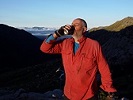
The AAWT heads down another 15 minutes to the Mt Speculation campsite. This would be one of the best campsites in the area. Surprisingly, I had the spacious site to myself. Three other walking parties chose to camp at the sheltered site down on the Speculation Road, closer to the water at Camp Creek. For the 45 minute round trip to collect water, I got million-dollar views of the sunset and sunrise. A fair trade, I thought!
- Mount Speculation campsite with a million dollar view
The next day started with an 8 km road bash along the Speculation Road towards the top of Muesli Spur. After stashing my pack at the top of the spur, I made a quick dash towards Mt Cobbler. I was racing the bad weather and pleased to have lunch in the clearing at the junction of the Mt Cobbler and Cobbler Lake tracks (GR 641994) before turning around.
The Muesli Spur Track is well maintained and well-trodden - school groups perhaps?? There is no scrambling, though there are one or two steep sections. After 1.5 hours of fairly consistent downhill, I got back to the car just as the rain was getting unpleasantly heavy.
- Track on upper Muesli Spur
As an aside, the first half of King Spur has the Mansfield State Forest on one side and the Alpine National Park on the other side. There was clear evidence of cattle grazing (cow pats!) in the state forest, confirmed by noisy bellowing as the rain set in on day two of the walk. However, the cows are clearly well trained in map reading because the cow pats disappeared once the spur emerged into the national park on both sides!