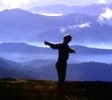
Took advantage of the fine weather and decided to give this walk a go.
Headed off 4:30am from Melbourne wanting to get an early start taking in account the tedious drive from Merrijig to Clear creek trailhead.
Was met with some deer hunters as I was about to walk up the road, assured me I wouldn't be shot I walked up the steep Nobs 4wd Track meeting up with the AAWT , was quite stuffed already hadn't even started the real walking yet , made my way over The Nobs , then onto Highcone was windy up high not sure if I was hot or cold as the wind was cold and a blaring warm Spring sun. from Highcone thru to Mt Clear the GPS became my best friend, the track would appear and then disappear and would be left scrub bashing over and under fallen trees etc..
Was 3pm by the time I made it to the saddle between Square Top And Mt Clear and was pretty well buggered and tempted to setup camp and relax , but decided I wanted to get to the saddle on the other side of Mt Clear so I had an easy walk the next day back to the car , made camp by 5ish and was happy to be snug in bed after woofing down dinner.
Was a tough walk and I enjoyed very much with spectacular country views.
Mt Clear Traverse 16-17 Sep
Forum rules
Posting large/multiple images in this forum is OK. Please start topic titles with the name of the location or track.
For topics focussed on photos rather than the trip, please consider posting in the 'Gallery' forum instead.
This forum is for posting information about trips you have done, not for requesting information about a track or area.
46 posts
• Page 1 of 2 • 1, 2
Mt Clear Traverse 16-17 Sep
![]() by Camminata » Sun 17 Sep, 2023 7:03 pm
by Camminata » Sun 17 Sep, 2023 7:03 pm
- Attachments
-
-
-
-
-
The Inbetween Is Mine
-

Camminata - Athrotaxis cupressoides

- Posts: 307
- Joined: Wed 17 Sep, 2014 11:38 am
- ASSOCIATED ORGANISATIONS: https://hikingtales55.blogspot.com
- Region: Victoria
- Gender: Male
Re: Mt Clear Traverse 16-17 Sep
![]() by Baeng72 » Mon 18 Sep, 2023 1:07 pm
by Baeng72 » Mon 18 Sep, 2023 1:07 pm
Nice report!
It was blowy when I camped on Mt. Koonika on the 14th into the morning of the 15th.
To get to the start, do you turn off for Sheepyard Flats, then onto Brock's road, past Bluff Link road and start at the 'clear creek track'?
It was blowy when I camped on Mt. Koonika on the 14th into the morning of the 15th.
To get to the start, do you turn off for Sheepyard Flats, then onto Brock's road, past Bluff Link road and start at the 'clear creek track'?
- Baeng72
- Athrotaxis selaginoides

- Posts: 1213
- Joined: Wed 07 Aug, 2019 2:29 pm
- Region: Victoria
- Gender: Male
Re: Mt Clear Traverse 16-17 Sep
![]() by Biggles » Mon 18 Sep, 2023 1:51 pm
by Biggles » Mon 18 Sep, 2023 1:51 pm
Ah, Mount Clear.
That trip was memorable for me (2010) for the bugger it was, (Queen's Birthday long weekend, June 2010). first day encountering patchy sun, then snow as we gained height along Clear Creek Track (most direct route), and then more winding on-road walks. This was via the Howqua Track to Brocks Road and terminus at North Jamieson River (car left here); no bridge over the Jamieson at the time. Pushed through raging current followed by a wring-dry on the other side then walk along Brocks Road, not The Nobs track.
Mount Clear was nondescript; water was about 500m away from a camp in a congested spring (fallen trees, scrub etc.). A fireplace was a saving grace: lit that until 8pm when the chill set in. And chill it was, dropping to minus 6 degrees overnight.
I virtually bum-skidded down Clear Creek Track on the return walk as it was iced over. I elected to return to the car next day, while two companions proceeded beyond Mount Clear on a circuit, only to get themselves lost in poor weather, return at nightfall, having flagged down a a 4WD when things got dicey. I had waited at the car almost frozen to the bone. Our return to Melbourne that night was close to midnight.
You got better, more memorable views than we did. Yes, it can be a challenging walk, but much more so in poor weather, as we found out. I was glad to get out of it and have not returned since.
Conversation about the weather is the last refuge of the unimaginative.
—Oscar Wilde, 1890.
—Oscar Wilde, 1890.
-
Biggles - Phyllocladus aspleniifolius

- Posts: 511
- Joined: Thu 14 May, 2009 12:14 pm
- Location: Castlemaine & Geelong
- Region: Victoria
- Gender: Male
Re: Mt Clear Traverse 16-17 Sep
![]() by Camminata » Mon 18 Sep, 2023 2:27 pm
by Camminata » Mon 18 Sep, 2023 2:27 pm
Baeng72 wrote:Nice report!
It was blowy when I camped on Mt. Koonika on the 14th into the morning of the 15th.
To get to the start, do you turn off for Sheepyard Flats, then onto Brock's road, past Bluff Link road and start at the 'clear creek track'?
I saw your vid looked a great spot to camp
Thanks mate, yes very blowy on the tops no interest in camping up high this time, drive pass Sheepyard Flats continuing on Brocks Rd past 8 Mile Gap, turn right when you get to intersection of Bluff Link and follow down into Jamieson Valley until you reach Clear creek rd.
The Inbetween Is Mine
-
Camminata - Athrotaxis cupressoides
- Posts: 307
- Joined: Wed 17 Sep, 2014 11:38 am
- ASSOCIATED ORGANISATIONS: https://hikingtales55.blogspot.com
- Region: Victoria
- Gender: Male
Re: Mt Clear Traverse 16-17 Sep
![]() by Camminata » Mon 18 Sep, 2023 2:32 pm
by Camminata » Mon 18 Sep, 2023 2:32 pm
Biggles wrote:Ah, Mount Clear.
That trip was memorable for me (2010) for the bugger it was, (Queen's Birthday long weekend, June 2010). first day encountering patchy sun, then snow as we gained height along Clear Creek Track (most direct route), and then more winding on-road walks. This was via the Howqua Track to Brocks Road and terminus at North Jamieson River (car left here); no bridge over the Jamieson at the time. Pushed through raging current followed by a wring-dry on the other side then walk along Brocks Road, not The Nobs track.
Mount Clear was nondescript; water was about 500m away from a camp in a congested spring (fallen trees, scrub etc.). A fireplace was a saving grace: lit that until 8pm when the chill set in. And chill it was, dropping to minus 6 degrees overnight.
I virtually bum-skidded down Clear Creek Track on the return walk as it was iced over. I elected to return to the car next day, while two companions proceeded beyond Mount Clear on a circuit, only to get themselves lost in poor weather, return at nightfall, having flagged down a a 4WD when things got dicey. I had waited at the car almost frozen to the bone. Our return to Melbourne that night was close to midnight.
You got better, more memorable views than we did. Yes, it can be a challenging walk, but much more so in poor weather, as we found out. I was glad to get out of it and have not returned since.
Sounds a great adventure these are the trips we remember forever, its def a challenging route, i didn't rely on the water source at the northern Saddle over Mt clear as I carried 4liter extra for a dry camp , but where is this spring headwaters of clear creek ???
Im not in a hurry to do this route again
The Inbetween Is Mine
-
Camminata - Athrotaxis cupressoides
- Posts: 307
- Joined: Wed 17 Sep, 2014 11:38 am
- ASSOCIATED ORGANISATIONS: https://hikingtales55.blogspot.com
- Region: Victoria
- Gender: Male
Re: Mt Clear Traverse 16-17 Sep
![]() by paidal_chalne_vala » Mon 18 Sep, 2023 4:00 pm
by paidal_chalne_vala » Mon 18 Sep, 2023 4:00 pm
I have done that hiking route . I did it solo and carried 4 L. extra water. I dry camped near High Cone IIRC. The water lasted me until I reached the camp site near Mt. Clear. The water supply is down a very old overgrown logging track. I have been up there before, maybe 2-3 times and it was always flowing.
It was a real relief to get that water. I recall doing that trek in late November. I could have and should have camped near Mt. Clear not far from the water supply for a second night but I slogged it down the MVO track back down to The car on Brock's road.
The camping options along Brocks road are good and there are some deep water holes for swimming in the Upper Jamieson river. It was a tough and remote hike that took in some of the AAWT. The GPS was useful because the track sometimes thinned out in places. The weather window I selected made for great views.
https://www.ski.com.au/xf/threads/aawt- ... st-4099531
Last edited by paidal_chalne_vala on Tue 19 Sep, 2023 3:57 pm, edited 1 time in total.
- paidal_chalne_vala
- Lagarostrobos franklinii

- Posts: 2693
- Joined: Sun 22 Jan, 2012 10:30 pm
- ASSOCIATED ORGANISATIONS: VNPA.BTAC.Friends of Baw Baw.Mt.Bogong Club.
- Region: Victoria
- Gender: Male
Re: Mt Clear Traverse 16-17 Sep
![]() by north-north-west » Mon 18 Sep, 2023 5:55 pm
by north-north-west » Mon 18 Sep, 2023 5:55 pm
I always used to do that circuit going up Big Mac, back before the north spur got buried under treefall and regrowth. Usually camped on High Cone. Good fun.
"Mit der Dummheit kämpfen Götter selbst vergebens."
-

north-north-west - Lagarostrobos franklinii
- Posts: 15378
- Joined: Thu 14 May, 2009 7:36 pm
- Location: The Asylum
- ASSOCIATED ORGANISATIONS: Social Misfits Anonymous
- Region: Tasmania
Re: Mt Clear Traverse 16-17 Sep
![]() by paidal_chalne_vala » Mon 18 Sep, 2023 6:38 pm
by paidal_chalne_vala » Mon 18 Sep, 2023 6:38 pm
According to reports from Bushwalking VIC. people I know, the Dept.of annual name changes have re cleared 3/4 of the North Spur route up Mt. McDonald.
It is on my radar to hike up that route this Nov..sometime.
It is on my radar to hike up that route this Nov..sometime.
- paidal_chalne_vala
- Lagarostrobos franklinii
- Posts: 2693
- Joined: Sun 22 Jan, 2012 10:30 pm
- ASSOCIATED ORGANISATIONS: VNPA.BTAC.Friends of Baw Baw.Mt.Bogong Club.
- Region: Victoria
- Gender: Male
Re: Mt Clear Traverse 16-17 Sep
![]() by Biggles » Mon 18 Sep, 2023 8:18 pm
by Biggles » Mon 18 Sep, 2023 8:18 pm
Sounds a great adventure these are the trips we remember forever, its def a challenging route, i didn't rely on the water source at the northern Saddle over Mt clear as I carried 4liter extra for a dry camp , but where is this spring headwaters of clear creek ???
Im not in a hurry to do this route again
Appearances suggest your second photo is where we camped. If memory serves me well, the spring (if it is permanent, or intermittent) is roughly SSE of there by a few hundred metres, descending slightly into an occluded gully. I have a vague recollection of following a vehicle track along here, but that could be just a fragment of memory mixed up from somewhere else! I think more accurate positioning can be found in Mapcarta.
Since that trip long ago I have walked solo to Mount McDonald via Brocks to Nobs Tk, taking the car over the (then, new) bridge over North Jamieson River (in 2010, the car was left in a permanently shadowed clearing just before the bridge-out crossing of the Jamieson). Mount McDonald and the view toward The Bluff is far more interesting and rewarding than landing diddly-squat in a chill, fog-enshrouded camp with no view anywhere except at one foot in front of the other.
I did not find Mount Clear particularly enthralling, nor rewarding for the effort involved, and a few other walkers in this neck of the woods (Bendigo district) have reported similar feelings, with one veteran describing the walk as a "stroll into nothingness in nowhere". The overnight cold, though, was something I have never forgotten!
Conversation about the weather is the last refuge of the unimaginative.
—Oscar Wilde, 1890.
—Oscar Wilde, 1890.
-
Biggles - Phyllocladus aspleniifolius
- Posts: 511
- Joined: Thu 14 May, 2009 12:14 pm
- Location: Castlemaine & Geelong
- Region: Victoria
- Gender: Male
Re: Mt Clear Traverse 16-17 Sep
![]() by Hiking Exped » Wed 20 Sep, 2023 11:51 am
by Hiking Exped » Wed 20 Sep, 2023 11:51 am
Nice trip report. I like that hike and certainly recall the first bit up to the AAWT on a hot summers day. Usually a nice camp spot about a km down the clear track with access to a good water source even in summer. Was the clear track pretty clear back down to Nobs?
- Hiking Exped
- Athrotaxis cupressoides
- Posts: 149
- Joined: Wed 13 Oct, 2021 8:05 am
- Region: Victoria
- Gender: Male
Re: Mt Clear Traverse 16-17 Sep
![]() by Camminata » Wed 20 Sep, 2023 1:43 pm
by Camminata » Wed 20 Sep, 2023 1:43 pm
Hiking Exped wrote:Nice trip report. I like that hike and certainly recall the first bit up to the AAWT on a hot summers day. Usually a nice camp spot about a km down the clear track with access to a good water source even in summer. Was the clear track pretty clear back down to Nobs?
Thanks, yeah was clear all the way down, was refreshing to get my feet wet at Clear Creek
The Inbetween Is Mine
-
Camminata - Athrotaxis cupressoides
- Posts: 307
- Joined: Wed 17 Sep, 2014 11:38 am
- ASSOCIATED ORGANISATIONS: https://hikingtales55.blogspot.com
- Region: Victoria
- Gender: Male
Re: Mt Clear Traverse 16-17 Sep
![]() by north-north-west » Wed 20 Sep, 2023 1:52 pm
by north-north-west » Wed 20 Sep, 2023 1:52 pm
paidal_chalne_vala wrote:According to reports from Bushwalking VIC. people I know, the Dept.of annual name changes have re cleared 3/4 of the North Spur route up Mt. McDonald.
If so, that's really good news. It's a wonderful walk.
"Mit der Dummheit kämpfen Götter selbst vergebens."
-
north-north-west - Lagarostrobos franklinii
- Posts: 15378
- Joined: Thu 14 May, 2009 7:36 pm
- Location: The Asylum
- ASSOCIATED ORGANISATIONS: Social Misfits Anonymous
- Region: Tasmania
Re: Mt Clear Traverse 16-17 Sep
![]() by Biggles » Wed 20 Sep, 2023 3:50 pm
by Biggles » Wed 20 Sep, 2023 3:50 pm
paidal_chalne_vala wrote:According to reports from Bushwalking VIC. people I know, the Dept.of annual name changes have re cleared 3/4 of the North Spur route up Mt. McDonald.
It is on my radar to hike up that route this Nov..sometime.
That name change has a bit of a hidden story to it with Forest Fire Management leading the charge!
Conversation about the weather is the last refuge of the unimaginative.
—Oscar Wilde, 1890.
—Oscar Wilde, 1890.
-
Biggles - Phyllocladus aspleniifolius
- Posts: 511
- Joined: Thu 14 May, 2009 12:14 pm
- Location: Castlemaine & Geelong
- Region: Victoria
- Gender: Male
Re: Mt Clear Traverse 16-17 Sep
![]() by scroggin » Wed 04 Oct, 2023 2:58 pm
by scroggin » Wed 04 Oct, 2023 2:58 pm
paidal_chalne_vala wrote:According to reports from Bushwalking VIC. people I know, the Dept.of annual name changes have re cleared 3/4 of the North Spur route up Mt. McDonald.
It is on my radar to hike up that route this Nov..sometime.
I hope they clear the GDR section of that walk which is more overgrown.
- scroggin
- Athrotaxis cupressoides
- Posts: 122
- Joined: Mon 28 Oct, 2013 11:52 am
- Region: Victoria
- Gender: Male
Re: Mt Clear Traverse 16-17 Sep
![]() by Camminata » Fri 27 Oct, 2023 2:23 pm
by Camminata » Fri 27 Oct, 2023 2:23 pm
Day 1 : Clear Creek to Mt Clear Saddle 15kms 8 hours
After having a few nice snow shoe hikes in the shortened snow season , was happy a warmish spring weekend was on the forecast and having this loop on my radar for a good 2 to 3 years I thought why not tackle the more remote isolated part of the Australian Alps National Park , this route would take in part of the AAWT
Headed off 4:30am from Melbourne wanting to get an early start taking in account the tedious drive from Merrijig to Clear creek trailhead, gave me plenty of time to think about what I was expecting on this hike bit nervy and also excited to be back into into the wilderness.
After an hour an half of bumpy slow drive in my VW van from Merrijig to Clear Creek trailhead & what felt like I was driving into the void as I descended into the Jamieson Valley, finally arrived. As I was getting ready and donned my pack I was met with some deer Hunters in their big forby ute muster tanks reminding me of the horror movie Wolf Creek. After a quick chit chat assuring me I wouldn’t be shot mistaken me for a deer I headed up the Nobs 4wd track which would lead me to the initial start of walk on the AAWT. I had read on sources that Nobs track was quite steep but not as steep and slippy with a loose rock surface I was blowing steam already, just as I rounded a corner the sound of one of the deer hunter come trudging up the track and this is where Wolf Creek thoughts crept into my head and thinking this is it for me. He offered a lift up to the top to AAWT turn off saving me the last 1 km of this road bash was happy to jump into back of his ute which was covered in blood from a fresh kill , it all added to the adventure.
Started walking on the faint footpad eyeing off in distance The Nobs which are two craggy peaks , the walking was beautiful with stunning Aussie bush all around me , having carrying extra 4 litres (+ 2 LITRES) of water .as I went with a loose plan not expecting to reach the headwaters of Mt Clear camp was expecting a dry camp somewhere along one of the many saddles so the extra weight was having an affect on my progress.
After a short scramble up the Nobs i could look down and see the spurs and ridgline as shown on my paper map very clearly , after a short break I was heading towards High Cone, the wind was blowing I think around 40kms an hour on the tops and with a blaring Spring sun I wasn’t sure if I was cold or hot.
After a couple hours or so I made it over to High Cone and happy with my progress so far was really enjoying the wild remote feeling on this route. After a short snack break of dried fruits nuts and a banana I was on my way, I could see Mt Clear in the distance and also another bump along the way, a so called peak I had to go up first named Square top, not sure how the name come about as it looks more like a pointy triangular shape….
Navigation so far had been quite straight forward, following a faint footpad and having read on another report of the area of it being overgrown in places along the trail I got cocky and ahead of myself thinking meh! “Walk in the. Park!” Lol
So off I hiked down off Highcone , after about 20 minutes I lost the trail a couple of times but was soon back on course after a check on the GPS this went on for another half hour losing the trail & quick check of GPS was on my way and so on…………
Things took a turn and soon I was trying to locate the trail and finding no trail ,just over grown waist high shrub with fallen trees to climb over and under ,I soon found myself choosing my own path thru thick scrub, This went on for the next 2 hours or so, I was trying to get up on middle of the spur to get onto Square Top but somehow ended up sidling around it. I found a flat (clear of shrub, shelf ledge and thought this is too easy to be true but walked it anyway as it gave me a short sense of relief until I reached a dead scrubby end , I check the gps and to my surprise saw how far down the side of Square Top I was, by this stage I was feeling tired and exhausted and looking straight up of where I had to get back on top of the spur was soul destroying , I scrambled up a 70 degree slope over fallen tress and thick shrub , I got somewhere near the top blowing a lung out or two and as I looked down a fat long copperhead snake lay there basking in the sun, scared the crap out of me. A sense full of despair overcome me.
After a short regroup to check map and gps I wasn’t too far from the saddle before Mt Clear still following a non existent trail it was somewhat easier as I was on middle of spur heading down hill and finally a clearing was in sight of the saddle between Mt Clear and Square Top, was much relieved and feeling parched I guzzled down a good half litre of water, fair to say I was really buggered sore calf muscles, sore shoulders etc…. Was thinking would be tempting just to set up camp now and relax for the rest of afternoon was 3pm, or try and make a dash over Mt Clear onto the intended campsite , I figured out would approx be an hour up to summit of Mt Clear and down other side another hour , could see that trail was not dense upon the southern slopes, so figure the bush bashing was behind me, so with a chocky bar and another banana to give some last energy boost as I felt I was running on vapours decided I would go for it and have an easy walk back down to car the next day.
Got up Mt Clear after a steep scramble the wind had picked up speed by late afternoon and wasn’t too interested in hanging out on top of Mt Clears flat open area for too long, tunnel vision had set in for reaching camp as I was racing against sundown as I didn't want to be navigating in the dark. and sure enough just after 5pm I stumbled & limped into camp, was feeling awesome but buggered .
Eating dinner of penne pasta with meatballs I had cooked before this trip went down a treat followed by some fruit, cups of tea and Lindt dark chocolate and beautiful sunset. I Was in bed by 7:30 all cozy reading “127 hours which I started reading in 2016 and between time off covid lockdowns am still reading it as I only read where I left off on hike trips.
Was around 9:30 pm I started to experience painful thigh cramps, I would bend my legs up and would be in agonising pain, felt like my thighs were going to pop out of my skin I slowly crawled out of the tent to stand up & massage legs, thighs in particular ,and gobbed down a pack of Pringles, I figure I lost too much salts and didn’t drink enough water during the day.
Day 2= Mt Clear Saddle to Clear Creek 8 kms 4 hours
Woke up 6ish in morning feeling good leg cramps gone, broke camp bit after 7 and headed down Clear creek Spur.
Was relaxing cruise walk with open clear trail with nice bush around me ,a big contrast to yesterdays walking, the trail runs parallel to the previous days route and could look across from afar at the undulating ridge & see what I had walked and felt quite rewarded and reflecting back was one to remember with spectacular views I do and enjoy these tough adventure hikes but won’t be in a hurry to do this one again!.
Was back at the car by 11 and headed off back to Melbourne via a lunch and coffee in Mansfield.
Last edited by Camminata on Fri 27 Oct, 2023 7:17 pm, edited 2 times in total.
The Inbetween Is Mine
-
Camminata - Athrotaxis cupressoides
- Posts: 307
- Joined: Wed 17 Sep, 2014 11:38 am
- ASSOCIATED ORGANISATIONS: https://hikingtales55.blogspot.com
- Region: Victoria
- Gender: Male
Re: Mt Clear Traverse 16-17 Sep
![]() by Baeng72 » Fri 27 Oct, 2023 3:05 pm
by Baeng72 » Fri 27 Oct, 2023 3:05 pm
Nice extended report.
An hour to get to trailhead?
It takes me near an hour to get to 8-mile flat from Merrijg. I must be slow.
Sounds like a fun in hindsight (type 2 fun) kind of day.
I'm not sure I want to do that hike now...
Why we do it?
I used to get those horrible leg cramps and sometimes by stretching out the muscles, the antagonistic muscles would cramp, and trying to crawl out of tent with legs locking up in painful cramp would lead to abdominal or near full-body cramps.
I was hiking with the family one time, and had an extreme cramp. Apparently it was quite funny for those watching.
These days it's not as bad, thankfully.
For me, it's not just electrolytes, it's fatigue. If I haven't done hard slogs for a while, and then go silly, there will come a point that no matter how much electrolytes I've drunk I still cramp.
I had it heading down Staircase Spur in the legs in September as I think walking up to the tree line with a full pack, and then back down same day was pushing my limits and upper legs started to cramp near Staircase Trailhead.
The good think about them is, they don't hang around that long, maybe 15 minutes of pain and contortions then it'll go away.
- Baeng72
- Athrotaxis selaginoides
- Posts: 1213
- Joined: Wed 07 Aug, 2019 2:29 pm
- Region: Victoria
- Gender: Male
Re: Mt Clear Traverse 16-17 Sep
![]() by Xplora » Sat 28 Oct, 2023 6:57 am
by Xplora » Sat 28 Oct, 2023 6:57 am
Most electrolyte replacements do not contain magnesium. Mg is very important and will help with cramps. Learnt that from years of ultra marathon running.
- Xplora
- Athrotaxis selaginoides
- Posts: 1653
- Joined: Sat 01 Aug, 2015 7:24 am
- Region: Victoria
- Gender: Male
Re: Mt Clear Traverse 16-17 Sep
![]() by north-north-west » Sat 28 Oct, 2023 8:56 am
by north-north-west » Sat 28 Oct, 2023 8:56 am
Vegemite.
I often get cramp in the evening after a long day walking. Vegemite with breakfast prevents it. Adequate hydration helps, obviously, but Vegemite is the big thing.
*note: this is purely personal experience. YMMV
I often get cramp in the evening after a long day walking. Vegemite with breakfast prevents it. Adequate hydration helps, obviously, but Vegemite is the big thing.
*note: this is purely personal experience. YMMV
"Mit der Dummheit kämpfen Götter selbst vergebens."
-
north-north-west - Lagarostrobos franklinii
- Posts: 15378
- Joined: Thu 14 May, 2009 7:36 pm
- Location: The Asylum
- ASSOCIATED ORGANISATIONS: Social Misfits Anonymous
- Region: Tasmania
Re: Mt Clear Traverse 16-17 Sep
![]() by Baeng72 » Sat 28 Oct, 2023 11:09 am
by Baeng72 » Sat 28 Oct, 2023 11:09 am
Xplora wrote:Most electrolyte replacements do not contain magnesium. Mg is very important and will help with cramps. Learnt that from years of ultra marathon running.
I have in the past taken Magnesium tablets when bushwalking, but fell out of habit some time ago. Need to change that then.
- Baeng72
- Athrotaxis selaginoides
- Posts: 1213
- Joined: Wed 07 Aug, 2019 2:29 pm
- Region: Victoria
- Gender: Male
Re: Mt Clear Traverse 16-17 Sep
![]() by Baeng72 » Sat 28 Oct, 2023 11:12 am
by Baeng72 » Sat 28 Oct, 2023 11:12 am
north-north-west wrote:Vegemite.
I often get cramp in the evening after a long day walking. Vegemite with breakfast prevents it. Adequate hydration helps, obviously, but Vegemite is the big thing.
*note: this is purely personal experience. YMMV
I need to start eating a proper breakfast when out in the bush then.
Toaster, bread, cheese, vegemite, real salty butter. I can justify the pack weight now!
Sadly, I never feel hungry in the morning when camping/walking and usually just force down a muesli bar or some sugary thing as I start walking.
- Baeng72
- Athrotaxis selaginoides
- Posts: 1213
- Joined: Wed 07 Aug, 2019 2:29 pm
- Region: Victoria
- Gender: Male
Re: Mt Clear Traverse 16-17 Sep
![]() by north-north-west » Sat 28 Oct, 2023 3:44 pm
by north-north-west » Sat 28 Oct, 2023 3:44 pm
Baeng72 wrote:I need to start eating a proper breakfast when out in the bush then.
Toaster, bread, cheese, vegemite, real salty butter. I can justify the pack weight now!
Sadly, I never feel hungry in the morning when camping/walking and usually just force down a muesli bar or some sugary thing as I start walking.
I'm not a breakfast person; at home I don't usually eat before 10am at the earliest and that's just a simple sandwich and some fruit.
But I've learnt the hard way that I can't do that on multiday walks, so I force down a small bowl of fruity muesli and get gross with the vegemite after. (Basically just dip in the spoon and lick the stuff off.) Like everything else I do out bush, it isn't pretty but it works well enough.
"Mit der Dummheit kämpfen Götter selbst vergebens."
-
north-north-west - Lagarostrobos franklinii
- Posts: 15378
- Joined: Thu 14 May, 2009 7:36 pm
- Location: The Asylum
- ASSOCIATED ORGANISATIONS: Social Misfits Anonymous
- Region: Tasmania
Re: Mt Clear Traverse 16-17 Sep
![]() by Camminata » Sat 28 Oct, 2023 4:04 pm
by Camminata » Sat 28 Oct, 2023 4:04 pm
north-north-west wrote:Baeng72 wrote:I need to start eating a proper breakfast when out in the bush then.
Toaster, bread, cheese, vegemite, real salty butter. I can justify the pack weight now!
Sadly, I never feel hungry in the morning when camping/walking and usually just force down a muesli bar or some sugary thing as I start walking.
I'm not a breakfast person; at home I don't usually eat before 10am at the earliest and that's just a simple sandwich and some fruit.
But I've learnt the hard way that I can't do that on multiday walks, so I force down a small bowl of fruity muesli and get gross with the vegemite after. (Basically just dip in the spoon and lick the stuff off.) Like everything else I do out bush, it isn't pretty but it works well enough.
Maybe a Vegemite with hot water and tea would be better than the spoon trick....
The Inbetween Is Mine
-
Camminata - Athrotaxis cupressoides
- Posts: 307
- Joined: Wed 17 Sep, 2014 11:38 am
- ASSOCIATED ORGANISATIONS: https://hikingtales55.blogspot.com
- Region: Victoria
- Gender: Male
Re: Mt Clear Traverse 16-17 Sep
![]() by north-north-west » Sat 28 Oct, 2023 7:26 pm
by north-north-west » Sat 28 Oct, 2023 7:26 pm
Camminata wrote:north-north-west wrote:Baeng72 wrote:I need to start eating a proper breakfast when out in the bush then.
Toaster, bread, cheese, vegemite, real salty butter. I can justify the pack weight now!
Sadly, I never feel hungry in the morning when camping/walking and usually just force down a muesli bar or some sugary thing as I start walking.
I'm not a breakfast person; at home I don't usually eat before 10am at the earliest and that's just a simple sandwich and some fruit.
But I've learnt the hard way that I can't do that on multiday walks, so I force down a small bowl of fruity muesli and get gross with the vegemite after. (Basically just dip in the spoon and lick the stuff off.) Like everything else I do out bush, it isn't pretty but it works well enough.
Maybe a Vegemite with hot water and tea would be better than the spoon trick....
Takes too long: fire up the stove, heat the water, blah blah blah. You do it your way, I'll do it mine.
"Mit der Dummheit kämpfen Götter selbst vergebens."
-
north-north-west - Lagarostrobos franklinii
- Posts: 15378
- Joined: Thu 14 May, 2009 7:36 pm
- Location: The Asylum
- ASSOCIATED ORGANISATIONS: Social Misfits Anonymous
- Region: Tasmania
Re: Mt Clear Traverse 16-17 Sep
![]() by Camminata » Sun 29 Oct, 2023 7:13 am
by Camminata » Sun 29 Oct, 2023 7:13 am
NNW
Takes too long: fire up the stove, heat the water, blah blah blah. You do it your way, I'll do it mine.[/quote]
take it easy... was a suggestion, not forcing you to do this........
Takes too long: fire up the stove, heat the water, blah blah blah. You do it your way, I'll do it mine.[/quote]
take it easy... was a suggestion, not forcing you to do this........
The Inbetween Is Mine
-
Camminata - Athrotaxis cupressoides
- Posts: 307
- Joined: Wed 17 Sep, 2014 11:38 am
- ASSOCIATED ORGANISATIONS: https://hikingtales55.blogspot.com
- Region: Victoria
- Gender: Male
Re: Mt Clear Traverse 16-17 Sep
![]() by north-north-west » Sun 29 Oct, 2023 9:02 am
by north-north-west » Sun 29 Oct, 2023 9:02 am
I'm not being aggro, mate.
"Mit der Dummheit kämpfen Götter selbst vergebens."
-
north-north-west - Lagarostrobos franklinii
- Posts: 15378
- Joined: Thu 14 May, 2009 7:36 pm
- Location: The Asylum
- ASSOCIATED ORGANISATIONS: Social Misfits Anonymous
- Region: Tasmania
Re: Mt Clear Traverse 16-17 Sep
![]() by paidal_chalne_vala » Wed 01 Nov, 2023 3:22 pm
by paidal_chalne_vala » Wed 01 Nov, 2023 3:22 pm
I did go a bit off track here and there when I walked this route but overall I did not experience the same difficulties as the O.P. .
I also carried extra water and camped near High Cone saddle. It was possible to spend another relaxing
night at the camping area near Mt. Clear , not far from where the water source is located , down a very overgrown bench cut logging track.
Consuming Hydrolyte sachets seem to work well for me these days in warding off cramps and fatigue .
I too walked out on day two .
- paidal_chalne_vala
- Lagarostrobos franklinii
- Posts: 2693
- Joined: Sun 22 Jan, 2012 10:30 pm
- ASSOCIATED ORGANISATIONS: VNPA.BTAC.Friends of Baw Baw.Mt.Bogong Club.
- Region: Victoria
- Gender: Male
Re: Mt Clear Traverse 16-17 Sep
![]() by Camminata » Wed 01 Nov, 2023 4:49 pm
by Camminata » Wed 01 Nov, 2023 4:49 pm
paidal_chalne_vala wrote:I did go a bit off track here and there when I walked this route but overall I did not experience the same difficulties as the O.P. .
I also carried extra water and camped near High Cone saddle. It was possible to spend another relaxing
night at the camping area near Mt. Clear , not far from where the water source is located , down a very overgrown bench cut logging track.
Consuming Hydrolyte sachets seem to work well for me these days in warding off cramps and fatigue .
I too walked out on day two .
They are planning on clearing part of the section I bashed thru, I reckon you had a clearer trail 4 YEARS ago.................
The Inbetween Is Mine
-
Camminata - Athrotaxis cupressoides
- Posts: 307
- Joined: Wed 17 Sep, 2014 11:38 am
- ASSOCIATED ORGANISATIONS: https://hikingtales55.blogspot.com
- Region: Victoria
- Gender: Male
Re: Mt Clear Traverse 16-17 Sep
![]() by paidal_chalne_vala » Wed 01 Nov, 2023 6:08 pm
by paidal_chalne_vala » Wed 01 Nov, 2023 6:08 pm
Mr. Patrick Platt from BTAC is planning a track clearing working bee on the AAWT
with a base camp at High Cone.
Access in February 2024 will be via the 4 x 4 Grimes track which comes up from the Barkly River valley area.
Personnel and equipment will be carted in by 4 x 4 vehicles.
Check the BTAC website
https://bushwalkingvictoria.org.au/btac/
for when exactly
the working bee is on
and when they will begin to recruit fit and able volunteers to contribute to this project.
- paidal_chalne_vala
- Lagarostrobos franklinii
- Posts: 2693
- Joined: Sun 22 Jan, 2012 10:30 pm
- ASSOCIATED ORGANISATIONS: VNPA.BTAC.Friends of Baw Baw.Mt.Bogong Club.
- Region: Victoria
- Gender: Male
Re: Mt Clear Traverse 16-17 Sep
![]() by GBW » Thu 02 Nov, 2023 4:18 pm
by GBW » Thu 02 Nov, 2023 4:18 pm
Camminata wrote:They are planning on clearing part of the section I bashed thru, I reckon you had a clearer trail 4 YEARS ago.................
I don't remember a "trail" at all between HC and ST, just a few AAWT markers.
Started like this...
Then this for 300m or so..
Then opened up to this on the approach to Square Top...
"If you wish to make an apple pie from scratch, you must first invent the universe"
-

GBW - Athrotaxis selaginoides
- Posts: 1175
- Joined: Fri 02 May, 2014 9:03 am
- Location: Melbourne
- Region: Victoria
- Gender: Male
Re: Mt Clear Traverse 16-17 Sep
![]() by Camminata » Thu 02 Nov, 2023 4:45 pm
by Camminata » Thu 02 Nov, 2023 4:45 pm
GBW wrote:Camminata wrote:They are planning on clearing part of the section I bashed thru, I reckon you had a clearer trail 4 YEARS ago.................
I don't remember a "trail" at all between HC and ST, just a few AAWT markers.
Started like this...
Then this for 300m or so..
Then opened up to this on the approach to Square Top..
I didn't see one AAWT marker
The Inbetween Is Mine
-
Camminata - Athrotaxis cupressoides
- Posts: 307
- Joined: Wed 17 Sep, 2014 11:38 am
- ASSOCIATED ORGANISATIONS: https://hikingtales55.blogspot.com
- Region: Victoria
- Gender: Male
46 posts
• Page 1 of 2 • 1, 2
Return to VIC Trip Reports & Track Notes
Who is online
Users browsing this forum: Google Adsense [Bot] and 9 guests