It was a lot of type 2 and 3 fun, but I did decide to go on a hot day.
Day 1. Upper Howqua to Mt. Buggery. 11 Hours walking with breaks.
I left Upper Howqua just after 8:30am on pretty warm day, and ambled along to Queens Spur rd.
Apart from the blackberries, I enjoy strolling along the Howqua.
Queen Spur rd was not a jumble of fallen trees as I'd expected. Someone has taken a chainsaw and cleared up almost everything in the intervening year. A big thank you.
I made it to Queen Spur rd/Stanley Name Spur junction in a little under 3 hours, feeling pretty hot under the sun and with little to no breeze.
After a good break, I decided to continue along Queen Spur rd.
It was scrubby and scratchy dry terrain at first, but not too much fallen timber, but that didn't last.
About half a km of battling with the thick scrub, the fallen stuff became dense and lots of squeezing under, over, around was done.
The track is pretty easy to follow, you can see the cutting into the hill of the benched track.
It heads downhill for the best part of a km, which makes it a little easier, then it starts rising slowly before the south branch of the King River.
- Queen Spur track sample
- scrubb-n-trees0090.png (324.7 KiB) Viewed 9899 times
It gets a bit greener near the branch, which is the same that passes Stanley Name Spur campsite, and isn't far as the crow flies, but I wouldn't try to walk directly between the 2 points.
After a break, and filling up all water containers, I immediately pushed through a heap of big fallen trees.
That got a bit better, and it was back to scratch head high stuff mostly in dry terrain.
It greened up a bit after a while, and few of *&%$#! blackberries that are everywhere near a creek between the two branches of the King River.
I got a bit misplaced after this. I think I was pretty much cooked from the heat and just followed a contouring animal track to a nice green open area and another waterway.
I thought the Avenza App/GetLost topo combo was confused by the surrounding hills, but it was I who was confounded and I'd arrived at the north branch of the King River, but didn't know it.
I realized this after a few minutes and backpedaled a few hundred meters to near the previous waterway, then saw where the benched cutting peeled away to the right and had started to rise.
I followed this through more head high scratchy stuff and fallen trees and got to the right place on the north branch of the King River.
- King River, north branch I think.
After this the track heads away from the river and upwards through more scrub and lots of fallen timber.
At about 1300m, I saw what looked like an animal track and left the Queen Spur road and headed up onto the spur.
This animal trail (I guess it was an animal trail) was easier than the road walking.
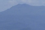
Not long after I was on the spur proper and soon came up to a point where I saw lots of bluffs and Mt. Buggery towering above.
- Queen Spur bluffs, Mt. Buggery
- thumb0131.png (199.99 KiB) Viewed 9899 times
If Queen Spur road hadn't been such a pain, and I hadn't really been up for a walk I might have packed it in and headed back some point here or soon after.
But I was too far in to go back, or committed, or something like that.
I found that each Bluff could be managed by going to the right, and finding a not too exposed scramble.
One bluff was bit tricky with pack on, but I scrambled up sans pack, and used some cord I had to pull the pack up after me.
Anyway, this pattern, of approach bluff, go up on right, repeat went on for about an hour.
The Spur narrowed worryingly at one point, but near the top it widened out, and the bluffs became pretty docile and easy to walk around on the right.
I eventually got to top of Mt. Buggery, there were some campers already there, so I didn't let massive screams of relief as I was inclined to do.
Day 2. Mt Buggery to Upper Howqua. 7 hours or a bit less.
The forecast had been for late rain on Sunday, but when I checked Saturday night (good reception on Mt. Buggery) it had changed to rain and storms by lunch time.
So, I got up early, didn't sleep great even though I had a nice spot.
I hadn't done the northern section of the traverse between Mt. Buggery and Mt. Howitt, so didn't know what to expect.
After a while I made it the first 'tooth' of the Crosscut, and it was pretty much daylight.
I was already a bit stuffed from the previous days exertions, but had to press on to try and get to Upper Howqua before possible storms and what I thought would be difficult driving out on Bindaree and Circuit roads.
It was slow going on all those ups and downs, but nice views.
- Crosscut Saw
Made to West Peak on Mount Howitt in a little over 3 hours, then headed down Howitt Spur.
I went as fast as I could without someone whipping me, and a few hours later I was crossing the Howqua branch and then kept on pushing to Upper Howqua in steady rain.
I didn't realize it, but leeches were enjoying a free meal on me.
Anyway, the drive out was fine, so I probably needn't have went as hard.
Here's a video of my travails. I don't think it's that interesting, but I put in a lot of the Bluffs on Queens Spur to help anybody who might want to try it.
https://youtu.be/dQNak8FTqKI