Game: Where-is-it (Aussie)
Only administrators may post new topics to this forum. Registered users can post replies.
Re: Game: Where-is-it (Aussie)
![]() by eggs » Sun 02 Feb, 2025 8:22 pm
by eggs » Sun 02 Feb, 2025 8:22 pm
-
eggs - Lagarostrobos franklinii

- Posts: 10856
- Joined: Fri 23 May, 2008 2:58 pm
- Location: Para Vista, South Australia
- Region: South Australia
Re: Game: Where-is-it (Aussie)
![]() by johnw » Sun 02 Feb, 2025 11:52 pm
by johnw » Sun 02 Feb, 2025 11:52 pm
eggs wrote:Maybe the Macs Point track - looking at Cathedral & Hump?
Yes eggs.
In Nature's keeping they are safe, but through the agency of man destruction is making rapid progress - John Muir c1912
-

johnw - Lagarostrobos franklinii
- Posts: 9684
- Joined: Wed 23 Jan, 2008 11:59 am
- Location: Macarthur Region - SW Sydney
- Region: New South Wales
- Gender: Male
-
eggs - Lagarostrobos franklinii
- Posts: 10856
- Joined: Fri 23 May, 2008 2:58 pm
- Location: Para Vista, South Australia
- Region: South Australia
Re: Game: Where-is-it (Aussie)
![]() by johnw » Tue 04 Feb, 2025 10:16 am
by johnw » Tue 04 Feb, 2025 10:16 am
In Nature's keeping they are safe, but through the agency of man destruction is making rapid progress - John Muir c1912
-
johnw - Lagarostrobos franklinii
- Posts: 9684
- Joined: Wed 23 Jan, 2008 11:59 am
- Location: Macarthur Region - SW Sydney
- Region: New South Wales
- Gender: Male
-
eggs - Lagarostrobos franklinii
- Posts: 10856
- Joined: Fri 23 May, 2008 2:58 pm
- Location: Para Vista, South Australia
- Region: South Australia
Re: Game: Where-is-it (Aussie)
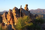
![]() by johnw » Tue 04 Feb, 2025 3:43 pm
by johnw » Tue 04 Feb, 2025 3:43 pm
- Mount Painter, Mount Painter NR via Belconnen ACT
In Nature's keeping they are safe, but through the agency of man destruction is making rapid progress - John Muir c1912
-
johnw - Lagarostrobos franklinii
- Posts: 9684
- Joined: Wed 23 Jan, 2008 11:59 am
- Location: Macarthur Region - SW Sydney
- Region: New South Wales
- Gender: Male
- sandym
- Phyllocladus aspleniifolius

- Posts: 657
- Joined: Wed 19 Sep, 2012 7:34 pm
- Region: New South Wales
- Gender: Female
Re: Game: Where-is-it (Aussie)
![]() by johnw » Tue 04 Feb, 2025 4:41 pm
by johnw » Tue 04 Feb, 2025 4:41 pm
sandym wrote:Cooleman Ridge?
Not Cooleman Ridge, a fair distance from there. Conceptually similar though.
In Nature's keeping they are safe, but through the agency of man destruction is making rapid progress - John Muir c1912
-
johnw - Lagarostrobos franklinii
- Posts: 9684
- Joined: Wed 23 Jan, 2008 11:59 am
- Location: Macarthur Region - SW Sydney
- Region: New South Wales
- Gender: Male
- keithj
- Athrotaxis cupressoides

- Posts: 307
- Joined: Sun 01 Nov, 2015 7:27 pm
- Region: New South Wales
- Gender: Male
Re: Game: Where-is-it (Aussie)
![]() by johnw » Tue 04 Feb, 2025 7:51 pm
by johnw » Tue 04 Feb, 2025 7:51 pm
keithj wrote:one tree hill ?
Not there either. You are about the same distance away from me as the previous guess but in the opposite direction.
In Nature's keeping they are safe, but through the agency of man destruction is making rapid progress - John Muir c1912
-
johnw - Lagarostrobos franklinii
- Posts: 9684
- Joined: Wed 23 Jan, 2008 11:59 am
- Location: Macarthur Region - SW Sydney
- Region: New South Wales
- Gender: Male
Re: Game: Where-is-it (Aussie)
![]() by Walk_fat boy_walk » Tue 04 Feb, 2025 8:40 pm
by Walk_fat boy_walk » Tue 04 Feb, 2025 8:40 pm
Sent from my Pixel 9 Pro using Tapatalk
- Walk_fat boy_walk
- Lagarostrobos franklinii
- Posts: 2354
- Joined: Sat 21 Nov, 2009 6:59 am
- Gender: Male
Re: Game: Where-is-it (Aussie)
![]() by johnw » Wed 05 Feb, 2025 8:32 am
by johnw » Wed 05 Feb, 2025 8:32 am
Walk_fat boy_walk wrote:Mt Painter
Correct, and I didn't even get to use my Michelangelo clue
In Nature's keeping they are safe, but through the agency of man destruction is making rapid progress - John Muir c1912
-
johnw - Lagarostrobos franklinii
- Posts: 9684
- Joined: Wed 23 Jan, 2008 11:59 am
- Location: Macarthur Region - SW Sydney
- Region: New South Wales
- Gender: Male
Re: Game: Where-is-it (Aussie)
![]() by Walk_fat boy_walk » Wed 05 Feb, 2025 10:50 am
by Walk_fat boy_walk » Wed 05 Feb, 2025 10:50 am
Sent from my Pixel 9 Pro using Tapatalk
- Walk_fat boy_walk
- Lagarostrobos franklinii
- Posts: 2354
- Joined: Sat 21 Nov, 2009 6:59 am
- Gender: Male
Re: Game: Where-is-it (Aussie)
![]() by Walk_fat boy_walk » Thu 06 Feb, 2025 6:10 pm
by Walk_fat boy_walk » Thu 06 Feb, 2025 6:10 pm
Sent from my Pixel 9 Pro using Tapatalk
- Walk_fat boy_walk
- Lagarostrobos franklinii
- Posts: 2354
- Joined: Sat 21 Nov, 2009 6:59 am
- Gender: Male
Re: Game: Where-is-it (Aussie)
![]() by snowygreybeard » Fri 07 Feb, 2025 9:27 am
by snowygreybeard » Fri 07 Feb, 2025 9:27 am
- snowygreybeard
- Atherosperma moschatum

- Posts: 72
- Joined: Fri 09 Nov, 2018 10:02 am
- Region: New South Wales
- Gender: Male
Re: Game: Where-is-it (Aussie)
![]() by puredingo » Fri 07 Feb, 2025 9:49 am
by puredingo » Fri 07 Feb, 2025 9:49 am
- puredingo
- Athrotaxis selaginoides

- Posts: 1326
- Joined: Mon 13 Feb, 2012 6:54 am
- Region: New South Wales
Re: Game: Where-is-it (Aussie)
![]() by Walk_fat boy_walk » Fri 07 Feb, 2025 10:14 am
by Walk_fat boy_walk » Fri 07 Feb, 2025 10:14 am
- Walk_fat boy_walk
- Lagarostrobos franklinii
- Posts: 2354
- Joined: Sat 21 Nov, 2009 6:59 am
- Gender: Male
Re: Game: Where-is-it (Aussie)
![]() by snowygreybeard » Fri 07 Feb, 2025 1:30 pm
by snowygreybeard » Fri 07 Feb, 2025 1:30 pm
(Yarrangobilly River)
- snowygreybeard
- Atherosperma moschatum
- Posts: 72
- Joined: Fri 09 Nov, 2018 10:02 am
- Region: New South Wales
- Gender: Male
Re: Game: Where-is-it (Aussie)
![]() by sandym » Fri 07 Feb, 2025 3:15 pm
by sandym » Fri 07 Feb, 2025 3:15 pm
- sandym
- Phyllocladus aspleniifolius
- Posts: 657
- Joined: Wed 19 Sep, 2012 7:34 pm
- Region: New South Wales
- Gender: Female
Re: Game: Where-is-it (Aussie)
![]() by snowygreybeard » Fri 07 Feb, 2025 3:22 pm
by snowygreybeard » Fri 07 Feb, 2025 3:22 pm
- snowygreybeard
- Atherosperma moschatum
- Posts: 72
- Joined: Fri 09 Nov, 2018 10:02 am
- Region: New South Wales
- Gender: Male
Re: Game: Where-is-it (Aussie)
![]() by sandym » Fri 07 Feb, 2025 6:09 pm
by sandym » Fri 07 Feb, 2025 6:09 pm
NSW:
- sandym
- Phyllocladus aspleniifolius
- Posts: 657
- Joined: Wed 19 Sep, 2012 7:34 pm
- Region: New South Wales
- Gender: Female
Re: Game: Where-is-it (Aussie)
![]() by snowygreybeard » Sat 08 Feb, 2025 8:23 am
by snowygreybeard » Sat 08 Feb, 2025 8:23 am
sandym wrote:When was that photo taken? I think it is much bushier now.
Photo taken last week. A couple of kms downstream from Yarrangobilly village
- snowygreybeard
- Atherosperma moschatum
- Posts: 72
- Joined: Fri 09 Nov, 2018 10:02 am
- Region: New South Wales
- Gender: Male
Re: Game: Where-is-it (Aussie)
![]() by johnw » Sat 08 Feb, 2025 2:51 pm
by johnw » Sat 08 Feb, 2025 2:51 pm
In Nature's keeping they are safe, but through the agency of man destruction is making rapid progress - John Muir c1912
-
johnw - Lagarostrobos franklinii
- Posts: 9684
- Joined: Wed 23 Jan, 2008 11:59 am
- Location: Macarthur Region - SW Sydney
- Region: New South Wales
- Gender: Male
- sandym
- Phyllocladus aspleniifolius
- Posts: 657
- Joined: Wed 19 Sep, 2012 7:34 pm
- Region: New South Wales
- Gender: Female
Re: Game: Where-is-it (Aussie)
![]() by johnw » Sun 09 Feb, 2025 11:27 am
by johnw » Sun 09 Feb, 2025 11:27 am
NT:
- Zoomed in on Kata Tjuta from the Dune Viewing Area, Uluru-Kata Tjuta NP via Yulara NT
In Nature's keeping they are safe, but through the agency of man destruction is making rapid progress - John Muir c1912
-
johnw - Lagarostrobos franklinii
- Posts: 9684
- Joined: Wed 23 Jan, 2008 11:59 am
- Location: Macarthur Region - SW Sydney
- Region: New South Wales
- Gender: Male
Re: Game: Where-is-it (Aussie)
![]() by ribuck » Mon 10 Feb, 2025 2:43 am
by ribuck » Mon 10 Feb, 2025 2:43 am
-

ribuck - Athrotaxis selaginoides
- Posts: 1895
- Joined: Wed 15 May, 2013 3:47 am
- Region: Other Country
- Gender: Male
Re: Game: Where-is-it (Aussie)
![]() by johnw » Mon 10 Feb, 2025 10:24 am
by johnw » Mon 10 Feb, 2025 10:24 am
ribuck wrote:There's a lot of zoom in that photo. I wonder if it's Mt Zeil.
Not Mt Zeil, I'm a long way from there. Yes a lot of zoom.
In Nature's keeping they are safe, but through the agency of man destruction is making rapid progress - John Muir c1912
-
johnw - Lagarostrobos franklinii
- Posts: 9684
- Joined: Wed 23 Jan, 2008 11:59 am
- Location: Macarthur Region - SW Sydney
- Region: New South Wales
- Gender: Male
Re: Game: Where-is-it (Aussie)
![]() by eggs » Mon 10 Feb, 2025 3:00 pm
by eggs » Mon 10 Feb, 2025 3:00 pm
The shape is roughly that of the biggest block there
-
eggs - Lagarostrobos franklinii
- Posts: 10856
- Joined: Fri 23 May, 2008 2:58 pm
- Location: Para Vista, South Australia
- Region: South Australia
Re: Game: Where-is-it (Aussie)
![]() by johnw » Mon 10 Feb, 2025 4:40 pm
by johnw » Mon 10 Feb, 2025 4:40 pm
eggs wrote:Probably the Olgas. But if you are zooming a long way I am not sure what answer you are after.
The shape is roughly that of the biggest block there
Nothing obscure eggs, just the name of the feature/s.
Yes Kata Tjuta (The Olgas) from the substantial Dune Viewing Area off the road between there and Uluru/Yulara.
In Nature's keeping they are safe, but through the agency of man destruction is making rapid progress - John Muir c1912
-
johnw - Lagarostrobos franklinii
- Posts: 9684
- Joined: Wed 23 Jan, 2008 11:59 am
- Location: Macarthur Region - SW Sydney
- Region: New South Wales
- Gender: Male
Re: Game: Where-is-it (Aussie)
![]() by eggs » Wed 12 Feb, 2025 10:21 am
by eggs » Wed 12 Feb, 2025 10:21 am
-
eggs - Lagarostrobos franklinii
- Posts: 10856
- Joined: Fri 23 May, 2008 2:58 pm
- Location: Para Vista, South Australia
- Region: South Australia
Return to Games and Competitions
Who is online
Users browsing this forum: No registered users and 28 guests