http://www.abc.net.au/news/2017-07-12/skeletal-remains-found-near-tahune-airwalk/8700962
No links yet to previous missing person reports or searches. One hopes they found more to identify the person.
Remains found - Huon Valley
Forum rules
Tasmania specific bushwalking discussion. Please avoid publishing details of access to sensitive areas with no tracks.
Tasmania specific bushwalking discussion. Please avoid publishing details of access to sensitive areas with no tracks.
64 posts
• Page 1 of 3 • 1, 2, 3
Remains found - Huon Valley
![]() by gayet » Wed 12 Jul, 2017 12:46 pm
by gayet » Wed 12 Jul, 2017 12:46 pm
- gayet
- Phyllocladus aspleniifolius

- Posts: 952
- Joined: Sat 12 Feb, 2011 8:01 pm
- Location: Wallan
- Region: Victoria
- Gender: Female
Re: Remains found - Huon Valley
![]() by Strider » Wed 12 Jul, 2017 12:57 pm
by Strider » Wed 12 Jul, 2017 12:57 pm
This pack was also found near the remains. Hopefully someones memory will be triggered.
Sent from my SM-G930F using Tapatalk
Sent from my SM-G930F using Tapatalk
-
Strider - Lagarostrobos franklinii

- Posts: 5875
- Joined: Mon 07 Nov, 2011 6:55 pm
- Location: Point Cook
- Region: Victoria
- Gender: Male
Re: Remains found - Huon Valley
![]() by NickMonk » Wed 12 Jul, 2017 4:56 pm
by NickMonk » Wed 12 Jul, 2017 4:56 pm
Ok guys, I know a fair bit about this through work (police). I'm aware of everything found and where it was found. I have spoken with the investigating officer and said I would ask for help here.
1) The person is NOT reported missing in Tasmania. Obviously checks are being done Nationally and Internationally.
2) The backpack is a Mountain Designs Escape day pack.
3) There are Raichle boots (brand is now Mammut). Raichle brand ceased in 2009.
4) The area in question is south of the Huon Track and east of the old (official) Mt Picton track by maybe 1.5 kms each way.
5) The person is most likely an international visitor, but an interstate visitor couldn't be ruled out.
6) Historic logbooks will be requested - what log books are there in the area that we know of please? Huon Track of course, maybe a remote area one on the 'new' Mt Picton track? Any ideas here.
7) Definitely only prepared for a day trip. Given where it was I'd suggest well and truly lost, and probably died of exposure or injury, not starvation. But - speculation of course.
8 ) How did they get to the area? Yes we are going to check for cars etc that may have been found, but hitch hiking, a bus to the airwalk etc is all possible. Does anyone remember giving a lift to anyone out there?
9) Timeline - given the information we have I'd say most likely late December 2010 - April 2011, with January 2011 probably most likely.
10) Any information you have could be vitally important. Did you do a walk in the area around that time and see anyone that might be them?
11) This is going to be pretty difficult to get to the bottom of. There are a number of things to follow up, hopefully something gives us a break.
- NickMonk
- Atherosperma moschatum

- Posts: 85
- Joined: Thu 05 Feb, 2015 9:23 pm
- Region: Tasmania
- Gender: Male
Re: Remains found - Huon Valley
![]() by Azza » Wed 12 Jul, 2017 5:14 pm
by Azza » Wed 12 Jul, 2017 5:14 pm
NickMonk wrote:4) The area in question is south of the Huon Track and east of the old (official) Mt Picton track by maybe 1.5 kms each way.
That is a pretty out of the way location.
One wonders how someone could have possibly stumbled across the remains, what was their reason for being out there?
As I understand it the original northern route up Mt Picton hasn't seen much usage since the newer track was established.
I remember walking it 25 or so years ago in College and back then it wasn't necessarily that easy to follow, was a bit overgrown with cutting grass in places.
So I could totally understand someone getting lost on that track these days.
There is also meant to be a short cut into Blakes Opening coming from the end of Riveaux Rd to the Huon River.
-

Azza - Phyllocladus aspleniifolius
- Posts: 979
- Joined: Thu 06 Mar, 2008 11:26 am
Re: Remains found - Huon Valley
![]() by NickMonk » Wed 12 Jul, 2017 5:49 pm
by NickMonk » Wed 12 Jul, 2017 5:49 pm
Azza wrote:NickMonk wrote:4) The area in question is south of the Huon Track and east of the old (official) Mt Picton track by maybe 1.5 kms each way.
That is a pretty out of the way location.
One wonders how someone could have possibly stumbled across the remains, what was their reason for being out there?
As I understand it the original northern route up Mt Picton hasn't seen much usage since the newer track was established.
I remember walking it 25 or so years ago in College and back then it wasn't necessarily that easy to follow, was a bit overgrown with cutting grass in places.
So I could totally understand someone getting lost on that track these days.
There is also meant to be a short cut into Blakes Opening coming from the end of Riveaux Rd to the Huon River.
My understanding is they were being exploratory, as all old hands do from time to time. They are possibly members of this forum.
They certainly accessed the area from the end of Riveaux Rd, but I don't think there's a track there. Given the terrain it might cut some kms off the trip to Blakes Opening, but most likely not time due to scrub. Although you couldn't rule it out I doubt the deceased person would have taken such an option unless they were completely confused right from the outset. Realistically I'd suspect a trip to Mt Picton that went horribly wrong, but again, only speculation.
- NickMonk
- Atherosperma moschatum
- Posts: 85
- Joined: Thu 05 Feb, 2015 9:23 pm
- Region: Tasmania
- Gender: Male
Re: Remains found - Huon Valley
![]() by devoswitch » Wed 12 Jul, 2017 7:39 pm
by devoswitch » Wed 12 Jul, 2017 7:39 pm
NickMonk wrote:
6) Historic logbooks will be requested - what log books are there in the area that we know of please? Huon Track of course, maybe a remote area one on the 'new' Mt Picton track? Any ideas here
There is no log book on the Mt Picton track. Unless one has very recently been put it in.
-
devoswitch - Athrotaxis cupressoides

- Posts: 409
- Joined: Mon 30 Dec, 2013 5:36 pm
- Region: Tasmania
- Gender: Male
Re: Remains found - Huon Valley
![]() by Graham51 » Wed 12 Jul, 2017 8:12 pm
by Graham51 » Wed 12 Jul, 2017 8:12 pm
devoswitch wrote:NickMonk wrote:
6) Historic logbooks will be requested - what log books are there in the area that we know of please? Huon Track of course, maybe a remote area one on the 'new' Mt Picton track? Any ideas here
There is no log book on the Mt Picton track. Unless one has very recently been put it in.
But there is one on the summit of Mt Picton. Still there?
-

Graham51 - Lagarostrobos franklinii
- Posts: 3444
- Joined: Mon 11 Oct, 2010 7:19 pm
- Region: Tasmania
- Gender: Male
Re: Remains found - Huon Valley
![]() by NickMonk » Wed 12 Jul, 2017 8:25 pm
by NickMonk » Wed 12 Jul, 2017 8:25 pm
Graham51 wrote:devoswitch wrote:NickMonk wrote:
6) Historic logbooks will be requested - what log books are there in the area that we know of please? Huon Track of course, maybe a remote area one on the 'new' Mt Picton track? Any ideas here
There is no log book on the Mt Picton track. Unless one has very recently been put it in.
But there is one on the summit of Mt Picton. Still there?
Would definitely be interested to know if there is a logbook on the summit of Picton. If there is and it is old enough I'll go and photograph pages in it myself. Does anyone have any further info on this?
- NickMonk
- Atherosperma moschatum
- Posts: 85
- Joined: Thu 05 Feb, 2015 9:23 pm
- Region: Tasmania
- Gender: Male
Re: Remains found - Huon Valley
![]() by CasualNerd » Wed 12 Jul, 2017 8:51 pm
by CasualNerd » Wed 12 Jul, 2017 8:51 pm
NickMonk wrote:\Would definitely be interested to know if there is a logbook on the summit of Picton. If there is and it is old enough I'll go and photograph pages in it myself. Does anyone have any further info on this?
There definitely was in March 2016 when I was there, in an old ammo tin. Can't remember how old it was though sorry.
-
CasualNerd - Athrotaxis cupressoides
- Posts: 488
- Joined: Wed 03 Aug, 2011 3:33 pm
- Region: Tasmania
- Gender: Male
Re: Remains found - Huon Valley
![]() by Graham51 » Wed 12 Jul, 2017 8:58 pm
by Graham51 » Wed 12 Jul, 2017 8:58 pm
CasualNerd wrote:NickMonk wrote:\Would definitely be interested to know if there is a logbook on the summit of Picton. If there is and it is old enough I'll go and photograph pages in it myself. Does anyone have any further info on this?
There definitely was in March 2016 when I was there, in an old ammo tin. Can't remember how old it was though sorry.
I was there in February 2014 and I saw an entry from someone I know from 12 months before that and I'm sure it goes further back than that.
-
Graham51 - Lagarostrobos franklinii
- Posts: 3444
- Joined: Mon 11 Oct, 2010 7:19 pm
- Region: Tasmania
- Gender: Male
Re: Remains found - Huon Valley
![]() by NickMonk » Wed 12 Jul, 2017 9:16 pm
by NickMonk » Wed 12 Jul, 2017 9:16 pm
Cheers folks. Where exactly would I find the log book? Is it in an obvious spot?
- NickMonk
- Atherosperma moschatum
- Posts: 85
- Joined: Thu 05 Feb, 2015 9:23 pm
- Region: Tasmania
- Gender: Male
Re: Remains found - Huon Valley
![]() by stepbystep » Wed 12 Jul, 2017 9:31 pm
by stepbystep » Wed 12 Jul, 2017 9:31 pm
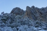
Summit logbook.
EDIT: It's on the summit.
Some ppl might be confusing, the current Picton Track 99% of walkers use these days from the old one that comes off the Huon Track as referred to by Nick.
All very intriguing, and sad. Hopefully a family will rest a bit easier after all this is resolved.
EDIT: It's on the summit.
Some ppl might be confusing, the current Picton Track 99% of walkers use these days from the old one that comes off the Huon Track as referred to by Nick.
All very intriguing, and sad. Hopefully a family will rest a bit easier after all this is resolved.
- Attachments
-
- IMG_2262.jpg (307.65 KiB) Viewed 45839 times
The idea of wilderness needs no defense, it only needs defenders ~ Edward Abbey
-

stepbystep - Lagarostrobos franklinii
- Posts: 7625
- Joined: Tue 19 May, 2009 10:19 am
- Location: Street urchin
- Region: Tasmania
- Gender: Male
Re: Remains found - Huon Valley
![]() by NickMonk » Wed 12 Jul, 2017 10:52 pm
by NickMonk » Wed 12 Jul, 2017 10:52 pm
stepbystep wrote:Summit logbook.
EDIT: It's on the summit.
LOL. Bet you'd never thought you'd use that photo for anything useful.
Cheers Dan, looks obvious enough if no snow around.
- NickMonk
- Atherosperma moschatum
- Posts: 85
- Joined: Thu 05 Feb, 2015 9:23 pm
- Region: Tasmania
- Gender: Male
Re: Remains found - Huon Valley
![]() by NickMonk » Wed 12 Jul, 2017 11:22 pm
by NickMonk » Wed 12 Jul, 2017 11:22 pm
Just came across Zane's blog post that states the summit log book was placed in 1997 and still only half-filled out. Thanks Zane, gotta love little details that are so helpful like this.
- NickMonk
- Atherosperma moschatum
- Posts: 85
- Joined: Thu 05 Feb, 2015 9:23 pm
- Region: Tasmania
- Gender: Male
Re: Remains found - Huon Valley
![]() by doogs » Thu 13 Jul, 2017 8:31 am
by doogs » Thu 13 Jul, 2017 8:31 am
I also believe there was a pad forming from the end of Riveaux road and used as a shortcut in to Blakes Opening. I became redundant when the forestry started locking the gate. The info is on this for somewhere..I'll try and find it.viewtopic.php?f=3&t=18564&p=251798&hilit=Riveaux+road#p251798
Do you want to build a snowman?
-

doogs - Lagarostrobos franklinii
- Posts: 3649
- Joined: Mon 11 Oct, 2010 4:32 pm
- Region: Tasmania
- Gender: Male
Re: Remains found - Huon Valley
![]() by GPSGuided » Thu 13 Jul, 2017 11:14 am
by GPSGuided » Thu 13 Jul, 2017 11:14 am
Heard on the ABC News Radio, CHF and HKD were found with the subject, suggesting he was an European, Swiss?
Just move it!
-
GPSGuided - Lagarostrobos franklinii
- Posts: 6801
- Joined: Mon 13 May, 2013 2:37 pm
- Location: Sydney
- Region: New South Wales
Re: Remains found - Huon Valley
![]() by NickMonk » Thu 13 Jul, 2017 11:34 am
by NickMonk » Thu 13 Jul, 2017 11:34 am
doogs wrote:I also believe there was a pad forming from the end of Riveaux road and used as a shortcut in to Blakes Opening. I became redundant when the forestry started locking the gate. The info is on this for somewhere..I'll try and find it.viewtopic.php?f=3&t=18564&p=251798&hilit=Riveaux+road#p251798
Thanks Doogs.
If anyone has travelled this route and has a GPS route of it I reckon we'd be interested to see it.
- NickMonk
- Atherosperma moschatum
- Posts: 85
- Joined: Thu 05 Feb, 2015 9:23 pm
- Region: Tasmania
- Gender: Male
Re: Remains found - Huon Valley
![]() by NickMonk » Thu 13 Jul, 2017 11:37 am
by NickMonk » Thu 13 Jul, 2017 11:37 am
GPSGuided wrote:Heard on the ABC News Radio, CHF and HKD were found with the subject, suggesting he was an European, Swiss?
The information we have suggests he certainly was in Zurich in late 2010, and exchanged Swiss Francs (I think) to AUD. So it could be inferred he was from Switzerland, but you couldn't rule out he was a traveller from elsewhere just leaving from Zurich.
- NickMonk
- Atherosperma moschatum
- Posts: 85
- Joined: Thu 05 Feb, 2015 9:23 pm
- Region: Tasmania
- Gender: Male
Re: Remains found - Huon Valley
![]() by tastrekker » Thu 13 Jul, 2017 11:41 am
by tastrekker » Thu 13 Jul, 2017 11:41 am
Knowledge of the Red Rag Scarp track is rather obscure for locals let alone for someone from overseas. I would therefore wonder if this forum could be the inspiration for our deceased mystery visitor's attempt.
Perhaps this thread which predates 2011:
http://bushwalk.com/forum/viewtopic.php?f=3&t=2914&p=42717&hilit=Red+rag+scarp#p30946
Any chance this site's metadata records and retains a record of every user who accesses a certain post? There may even be a timestamp and IP address available.
Also, here's a personal theory:
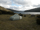
I suspect they were on an overnight hike and there's a tent, sleeping bag, stove, etc in some streamside location nearby(ish) and this fella had taken day walk gear in his overnight pack to 'scoot' up Picton and return to camp. Most experienced off-track walkers know just how dense the Tassie forest is in places. I think there's every chance no one has happened to stumble across this person's camp.
Perhaps this thread which predates 2011:
http://bushwalk.com/forum/viewtopic.php?f=3&t=2914&p=42717&hilit=Red+rag+scarp#p30946
Any chance this site's metadata records and retains a record of every user who accesses a certain post? There may even be a timestamp and IP address available.
Also, here's a personal theory:
I suspect they were on an overnight hike and there's a tent, sleeping bag, stove, etc in some streamside location nearby(ish) and this fella had taken day walk gear in his overnight pack to 'scoot' up Picton and return to camp. Most experienced off-track walkers know just how dense the Tassie forest is in places. I think there's every chance no one has happened to stumble across this person's camp.
-

tastrekker - Athrotaxis cupressoides
- Posts: 499
- Joined: Thu 20 Sep, 2007 9:04 pm
- Location: Lenah Valley
- Region: Tasmania
- Gender: Male
Re: Remains found - Huon Valley
![]() by tastrekker » Thu 13 Jul, 2017 11:56 am
by tastrekker » Thu 13 Jul, 2017 11:56 am
I'd be checking Hustling Creek and the funny little tarn at the foot of Red Rag Scarp for a possible camp location. It's relatively easy to find a mountain heading up hill as all the ridges are merging in your direction of travel. Descending is the opposite. It would be easy for someone camped in an obscure location to get benighted while trying to find their tent after descending the wrong ridge.
-
tastrekker - Athrotaxis cupressoides
- Posts: 499
- Joined: Thu 20 Sep, 2007 9:04 pm
- Location: Lenah Valley
- Region: Tasmania
- Gender: Male
Re: Remains found - Huon Valley
![]() by whynotwalk » Thu 13 Jul, 2017 12:16 pm
by whynotwalk » Thu 13 Jul, 2017 12:16 pm
More than 10 years ago, my son and I climbed Picton from the Cook Creek forestry roads (via Glassworm Tarn). We summited Picton, and the plan was to then head to Blakes Opening, and out via Tahune. But from the summit of Picton we were quite tempted to leave the scree early and head a little east and down towards Welcome Moraine. We didn't: but I remember looking down from the steep ridge towards the incredible tangle of vegetation around Hustling Creek and thinking "We could easily go down there and never be seen again." It's sad and eerie to think that's the kind of place this walker ended his/her days.
Peter
Peter
Solvitur ambulando (Walking solves it) - attributed to St Augustine, 4th century AD.
-
whynotwalk - Athrotaxis selaginoides

- Posts: 1335
- Joined: Tue 24 Jun, 2008 12:57 pm
- Location: Cascades
- Region: Tasmania
- Gender: Male
Re: Remains found - Huon Valley
![]() by Azza » Thu 13 Jul, 2017 1:09 pm
by Azza » Thu 13 Jul, 2017 1:09 pm
On theList "State Aerial Photographs" you can see some rather interesting features.
If you look at the end of Riveaux Road - there is what looks suspiciously like a track heading through the scrub towards the Huon Track.
This is likely to be the short cut route into Blakes Opening we were all referring to.
Also out on the plains South of Blake Opening there is a mysterious junction in the button grass with something a bit track like heading off east / SE'ish.
Could be a creek.... but looks a bit trackish.
The track on the aerial view doesn't align at all with the old 1:25k maps either.
-
Azza - Phyllocladus aspleniifolius
- Posts: 979
- Joined: Thu 06 Mar, 2008 11:26 am
Re: Remains found - Huon Valley
![]() by tastrekker » Thu 13 Jul, 2017 1:19 pm
by tastrekker » Thu 13 Jul, 2017 1:19 pm
The track over the plains lines up closely with the Red Rag Scarp track on the 1:25k map from TheLIST up where it enters the forest. I agree it doesn't line up further down towards the river.
(Sorry for the phone screen shots.)
(Sorry for the phone screen shots.)
-
tastrekker - Athrotaxis cupressoides
- Posts: 499
- Joined: Thu 20 Sep, 2007 9:04 pm
- Location: Lenah Valley
- Region: Tasmania
- Gender: Male
Re: Remains found - Huon Valley
![]() by NickMonk » Thu 13 Jul, 2017 1:52 pm
by NickMonk » Thu 13 Jul, 2017 1:52 pm
tastrekker wrote:I'd be checking Hustling Creek and the funny little tarn at the foot of Red Rag Scarp for a possible camp location. It's relatively easy to find a mountain heading up hill as all the ridges are merging in your direction of travel. Descending is the opposite. It would be easy for someone camped in an obscure location to get benighted while trying to find their tent after descending the wrong ridge.
That is a funny little tarn. Filled-in sinkhole?
You may be right about the camp tastrekker, but it's a difficult one to explore. Covering that area on foot would be a nightmare for searchers, and I doubt would be attempted without more specific information.
- NickMonk
- Atherosperma moschatum
- Posts: 85
- Joined: Thu 05 Feb, 2015 9:23 pm
- Region: Tasmania
- Gender: Male
Re: Remains found - Huon Valley
![]() by NickMonk » Thu 13 Jul, 2017 1:58 pm
by NickMonk » Thu 13 Jul, 2017 1:58 pm
Azza wrote:On theList "State Aerial Photographs" you can see some rather interesting features.
If you look at the end of Riveaux Road - there is what looks suspiciously like a track heading through the scrub towards the Huon Track.
This is likely to be the short cut route into Blakes Opening we were all referring to.
That 'cutting' appears to follow the alignment of Hustling Creek. But it would be a good shortcut if the bush isn't too bad down to the track.
To be honest I reckon the body location is probably only a km away from the end of Riveaux Rd as shown on the aerial photo.
- NickMonk
- Atherosperma moschatum
- Posts: 85
- Joined: Thu 05 Feb, 2015 9:23 pm
- Region: Tasmania
- Gender: Male
Re: Remains found - Huon Valley
![]() by doogs » Thu 13 Jul, 2017 2:25 pm
by doogs » Thu 13 Jul, 2017 2:25 pm
From Chapmans SW..edit. sorry about the upside down pic, the file size is too large when rotated and its proving difficult to sort on my phone!!
- Attachments
-
Do you want to build a snowman?
-
doogs - Lagarostrobos franklinii
- Posts: 3649
- Joined: Mon 11 Oct, 2010 4:32 pm
- Region: Tasmania
- Gender: Male
Re: Remains found - Huon Valley
![]() by MJD » Thu 13 Jul, 2017 6:17 pm
by MJD » Thu 13 Jul, 2017 6:17 pm
May or may not be useful but in 2009 two of us went in to Blakes Opening and the Eastern Arthurs from Riveaux Rd. GPS plot is the purple line. From the road we headed north down a pad but lost it and ended going too far to the east before picking up the YoYo Track. At the time I felt that there was another track starting even further West. I still have the gps track.
- Riveaux route
- Riveaux.png (163.85 KiB) Viewed 45406 times
Carpe diem
-

MJD - Athrotaxis selaginoides
- Posts: 1017
- Joined: Mon 26 May, 2008 11:24 pm
- Region: Tasmania
Re: Remains found - Huon Valley
![]() by vernicosa » Fri 14 Jul, 2017 9:28 am
by vernicosa » Fri 14 Jul, 2017 9:28 am
There was (and probably still is) a track from the end of Riveaux Rd linking to the Huon Track. I've walked it many times when working for Parks to access a Phytophora washdown at
Agate Ck and a Remote Registration Book at Blakes Opening. I haven't walked the link track since leaving
Parks in 2009.
The track was difficult to locate at both ends. It was taped with pink flagging tape and had some chainsaw cutting.
The forest has a fairly open understory.
At the Riveaux Rd end there is potential for confusion as there are other tapes
heading west whereas the link goes mostly north to meet the Huon Track west of Hustling Ck, 100 to 200m west from memory.
- vernicosa
- Nothofagus gunnii

- Posts: 20
- Joined: Tue 11 Jul, 2017 9:47 pm
- Region: Tasmania
- Gender: Male
Re: Remains found - Huon Valley
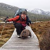
![]() by Singe » Fri 14 Jul, 2017 1:36 pm
by Singe » Fri 14 Jul, 2017 1:36 pm
TasPol have posted this photo on Facebook - found on an SD card in the backpack. 
“No man ever steps in the same river twice, for it is not the same river and he is not the same man.” -Heraclitus
-

Singe - Athrotaxis cupressoides
- Posts: 238
- Joined: Wed 30 Apr, 2008 4:45 pm
- Region: New South Wales
- Gender: Male
Re: Remains found - Huon Valley
![]() by devoswitch » Fri 14 Jul, 2017 1:55 pm
by devoswitch » Fri 14 Jul, 2017 1:55 pm
Where do the other tapes heading west on Riveaux rd go to? Is this where the two who found him went in?
Possible confusion from the start of walk and got disorientated/hurt?
I hope someone recognises the person in the photo although I'm sure we will never really know exactly what happened.
Possible confusion from the start of walk and got disorientated/hurt?
I hope someone recognises the person in the photo although I'm sure we will never really know exactly what happened.
-
devoswitch - Athrotaxis cupressoides
- Posts: 409
- Joined: Mon 30 Dec, 2013 5:36 pm
- Region: Tasmania
- Gender: Male
64 posts
• Page 1 of 3 • 1, 2, 3
Who is online
Users browsing this forum: No registered users and 6 guests